Tête de Grouvelin, Mountain summit in Gérardmer, France
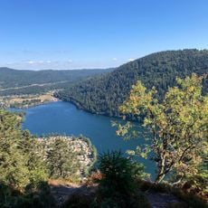
Tête de Grouvelin is a mountain summit in the Vosges rising to 1,137 meters and offering views across the surrounding range. The plateau is ringed by beech forests that open to meadows, with an orientation table showing distant peaks.
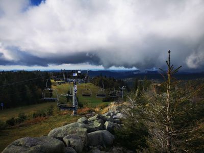
The summit became the focal point of La Mauselaine ski station, founded in the 1960s as a winter sports facility in the Vosges. This infrastructure has shaped the seasonal use of the mountain for decades.
The name Grouvelin comes from local dialect and refers to the alpine pasture landscape that has shaped this area for generations. Visitors today still encounter herds and traditional fencing that define the mountainside.
The trail is well marked and follows a circuit of about 10 kilometers from the base, with hikers able to choose different route segments. The path combines forest trails with open mountain paths suitable for various fitness levels.
The route combines ski slope sections with natural mountain paths, offering hikers in summer completely different views of the human-shaped landscape. In winter these areas transform into runs showing how the mountain adapts to seasonal use.
GPS coordinates: 48.04679,6.91669
Latest update: December 14, 2025 20:28
Ballons des Vosges Regional Natural Park
4 km
Saut des Cuves
4.2 km
Saut de la Bourrique
5.5 km
Charlemagne waterfall
5.5 km
Pont des Fées
4.5 km
Église Saint-Barthélemy de Gérardmer
3.9 km
Rainkopf
6.4 km
Cascade de Mérelle
6.1 km
Réserve naturelle nationale de la tourbière de Machais
5.5 km
Acro-Sphère
6.5 km
Cascade de Retournemer
5 km
Église Saint-Laurent de La Bresse
5.6 km
Chapelle Sainte-Anne de Martimpré
6.5 km
Immeuble Chevroton
4 km
Bowling La Bresse
6 km
Église Sainte-Bernadette de Xonrupt
3.9 km
Chapelle du Calvaire de Gérardmer
4.2 km
Seconde croix de chemin de la rue de la Clairie
5.6 km
Croix de chemin de la route de Vologne
4.8 km
Croix de chemin de la rue François Claudel
6.7 km
Croix de chemin des Feignes sous Vologne
4.3 km
Croix de chemin de la rue du Hohneck
5.1 km
Chapelle Saint-Florent
4 km
Église Saint-Étienne de Kichompré
5.4 km
Croix de chemin de la route de Vologne
4.9 km
Croix de chemin de la rue de la Clairie
5.8 km
Chapelle Saint-Jacques de Kichompré
5.5 km
Temple de l'église réformée de France de Gérardmer
4.3 kmVisited this place? Tap the stars to rate it and share your experience / photos with the community! Try now! You can cancel it anytime.
Discover hidden gems everywhere you go!
From secret cafés to breathtaking viewpoints, skip the crowded tourist spots and find places that match your style. Our app makes it easy with voice search, smart filtering, route optimization, and insider tips from travelers worldwide. Download now for the complete mobile experience.
A unique approach to discovering new places❞
— Le Figaro
All the places worth exploring❞
— France Info
A tailor-made excursion in just a few clicks❞
— 20 Minutes