Tête de Chétives, Mountain peak in Écrins National Park, France
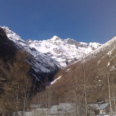
Tête de Chétives is a mountain peak in the French Alps reaching 2,644 meters elevation. The summit sits between Lake Labarre and Lake Gary in the Isère department within Écrins National Park.
The mountain was shaped by traditional alpine routes that developed over centuries through shepherding and local mountain life. These paths reflect the long history of mountain farming in this part of the Alps.
The mountain serves as a reference point for local shepherds who maintain the Alpine pastures according to traditional agricultural practices.
The complete hiking route takes around eight hours starting from the Confolens Waterfall parking area. Visitors should prepare for steep terrain and bring appropriate mountain gear.
From the summit, visitors can see four distinct mountain massifs: Armet, Taillefer, Écrins, and Signal du Lauvitel. This panorama makes it a valuable viewpoint for understanding the broader alpine landscape.
The community of curious travelers
AroundUs brings together thousands of curated places, local tips, and hidden gems, enriched daily by 60,000 contributors worldwide.