Enable Location

We need your location to show you interesting places around you

Discover nearby places

Find interesting locations and hidden gems around you

Precise directions

Get accurate directions and distances to places

Your location is never shared with other users. It's only used when you tap the location button.

Finn McCool's Fingers

Log in to your account

Start exploring — it's free

Trusted by 61,374 travelers worldwide

Continue with Google
Continue with Apple
or

We will send you a code to connect

By continuing, you accept our Terms and Conditions and our Privacy Policy

Check your inbox

We've sent a pincode in your inbox. Please enter the code below.

Finn McCool's Fingers

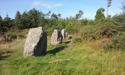
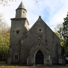
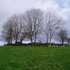
Finn McCool's Fingers, Prehistoric stone formation in Bailieborough-Cootehill, Ireland

Description

Finn McCool's Fingers comprises five standing stones positioned in a southeast to northwest alignment on Shantemon Mountain in County Cavan. The stones rise from open moorland and create a simple but striking line across the ridge of the hill.

History

The stones date to prehistoric times when megalithic structures were built across Ireland for territorial and ceremonial purposes. Over thousands of years, they remained standing on the mountainside while the landscape around them transformed.

Culture

The site takes its name from Fionn mac Cumhaill, a legendary warrior leader in Irish folklore whose stories are still told across the country. This naming shows how ancient rocks became connected to the heroes of local tradition over centuries.

Practical

The site is accessible through marked walking trails that cross the open moorland and hillsides of County Cavan. Weather conditions change quickly in this upland area, so appropriate footwear and windproof clothing are important for a comfortable visit.

Did you know?

The five stones align with solar events such as the sunrise or sunset at specific times of the year. This astronomical orientation hints that the builders had a sophisticated understanding of how the sky moves and changes through the seasons.

Location
Bailieborough-Cootehill Municipal District
GPS coordinates
54.01746,-7.29139
Latest update
December 13, 2025 17:00

AroundUs brings together thousands of curated places, local tips, and hidden gems, enriched daily by 60,000 contributors worldwide. Discover all places nearby (Bailieborough-Cootehill Municipal District).

« Finn McCool's Fingers - Prehistoric stone formation in Bailieborough-Cootehill, Ireland » is provided by Around Us (aroundus.com). Images and texts are derived from Wikimedia project under a Creative Commons license. You are allowed to copy, distribute, and modify copies of this page, under the conditions set by the license, as long as this note is clearly visible.

Discover hidden gems everywhere you go!

From secret cafés to breathtaking viewpoints, skip the crowded tourist spots and find places that match your style. Our app makes it easy with voice search, smart filtering, route optimization, and insider tips from travelers worldwide. Download now for the complete mobile experience.

Around Us App Screenshot

A unique approach to discovering new places

Le Figaro

All the places worth exploring

France Info

A tailor-made excursion in just a few clicks

20 Minutes

Around Us
Travel Guide & Maps
Download

Send to your phone

QR Code
1

Open the camera app on your mobile.

2

Point at the QR code with your camera. A notification will appear.

3

Tap the notification to open the link.