Enable Location

We need your location to show you interesting places around you

Discover nearby places

Find interesting locations and hidden gems around you

Precise directions

Get accurate directions and distances to places

Your location is never shared with other users. It's only used when you tap the location button.

Ghazipur district

Log in to your account

Start exploring — it's free

Trusted by 62,565 travelers worldwide

Continue with Google
Continue with Apple
or

We will send you a code to connect

By continuing, you accept our Terms and Conditions and our Privacy Policy

Check your inbox

We've sent a pincode in your inbox. Please enter the code below.

Ghazipur district

Ghazipur district, Administrative district in eastern Uttar Pradesh, India

Ghazipur is an administrative district in eastern Uttar Pradesh located along the Ganges River with fertile agricultural terrain. The region is characterized by extensive farming areas where wheat, rice, and sugarcane form the economic backbone of many communities.

The district came under British control in the late 18th century and was formally established in 1818. This formation made it an important administrative center during the colonial period.

The district maintains strong traditions with multiple languages including Hindi, Bhojpuri, and Urdu spoken by residents across its numerous villages and towns.

The district headquarters in Ghazipur city connects to larger urban centers through established railway networks and road systems. Visitors will find well-developed transport links that allow easy access from other regions.

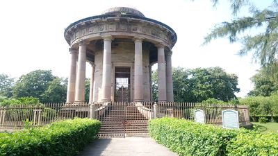
The tomb of Lord Cornwallis, a colonial-era monument, is preserved here under the care of the Archaeological Survey of India. The district is also known for producing traditional rose-scented water called Gulab Jal.

The community of curious travelers

AroundUs brings together thousands of curated places, local tips, and hidden gems, enriched daily by 60,000 contributors worldwide.

Start exploring
Capital city
Ghazipur
Shares border with
Azamgarh district, Kaimur district
GPS coordinates
25.58322,83.58086
Latest update
December 17, 2025 09:36
« Ghazipur district - Administrative district in eastern Uttar Pradesh, India » is provided by Around Us (aroundus.com). Images and texts are derived from Wikimedia project under a Creative Commons license. You are allowed to copy, distribute, and modify copies of this page, under the conditions set by the license, as long as this note is clearly visible.

Discover hidden gems everywhere you go!

From secret cafés to breathtaking viewpoints, skip the crowded tourist spots and find places that match your style. Our app makes it easy with voice search, smart filtering, route optimization, and insider tips from travelers worldwide. Download now for the complete mobile experience.

Around Us App Screenshot

A unique approach to discovering new places

Le Figaro

All the places worth exploring

France Info

A tailor-made excursion in just a few clicks

20 Minutes

Around Us
Travel Guide & Maps
Download

Send to your phone

QR Code
1

Open the camera app on your mobile.

2

Point at the QR code with your camera. A notification will appear.

3

Tap the notification to open the link.