Enable Location

We need your location to show you interesting places around you

Discover nearby places

Find interesting locations and hidden gems around you

Precise directions

Get accurate directions and distances to places

Your location is never shared with other users. It's only used when you tap the location button.

Chandrapur district

Log in to your account

Start exploring — it's free

Trusted by 61,465 travelers worldwide

Continue with Google
Continue with Apple
or

We will send you a code to connect

By continuing, you accept our Terms and Conditions and our Privacy Policy

Check your inbox

We've sent a pincode in your inbox. Please enter the code below.

Chandrapur district

Chandrapur district, Administrative district in Nagpur division, India

Description

Chandrapur district is an administrative region in eastern Maharashtra covering roughly 11,400 square kilometers and divided into fifteen administrative units. The area contains extensive coal mining operations concentrated in the Wardha Valley.

History

The district was created in 1981 when the government separated it from the former Chanda district and carved out new territories. The tehsils of Gadchiroli and Sironcha were removed to form separate administrative units.

Culture

Marathi is the main language spoken here, and Hindu, Buddhist, and Muslim communities shape daily life through their traditions and celebrations. These groups have woven their practices into the rhythm of the district over generations.

Practical

The district connects to other regions via National Highway 353E and has a railway station on the main line between New Delhi and Chennai. These transport links make it relatively accessible from different directions.

Did you know?

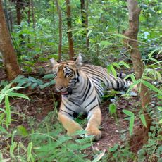
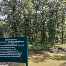
The Tadoba Andhari Tiger Reserve within the district protects a substantial tiger population while the same region holds major coal reserves. This coexistence of wildlife protection and mineral extraction shapes the area in unexpected ways.

Location
Capital city
Chandrapur
Shares border with
Wardha district
GPS coordinates
19.95000,79.30000
Latest update
December 17, 2025 07:51

AroundUs brings together thousands of curated places, local tips, and hidden gems, enriched daily by 60,000 contributors worldwide. Discover all places nearby (Nagpur division).

« Chandrapur district - Administrative district in Nagpur division, India » is provided by Around Us (aroundus.com). Images and texts are derived from Wikimedia project under a Creative Commons license. You are allowed to copy, distribute, and modify copies of this page, under the conditions set by the license, as long as this note is clearly visible.

Discover hidden gems everywhere you go!

From secret cafés to breathtaking viewpoints, skip the crowded tourist spots and find places that match your style. Our app makes it easy with voice search, smart filtering, route optimization, and insider tips from travelers worldwide. Download now for the complete mobile experience.

Around Us App Screenshot

A unique approach to discovering new places

Le Figaro

All the places worth exploring

France Info

A tailor-made excursion in just a few clicks

20 Minutes

Around Us
Travel Guide & Maps
Download

Send to your phone

QR Code
1

Open the camera app on your mobile.

2

Point at the QR code with your camera. A notification will appear.

3

Tap the notification to open the link.