Gualdo Tadino, Medieval commune in northeastern Umbria, Italy
Gualdo Tadino is a commune in the province of Perugia situated on the lower slopes of Mount Penna at about 536 meters elevation. The town spreads across several districts with ancient stone buildings and narrow winding streets that follow the hillside layout.
Originally called Tadinum, the settlement suffered repeated destruction from Hannibal's attack in 217 BC and later from the Visigoths in 410 AD. These early conflicts shaped the region's turbulent past and left lasting marks on its development.
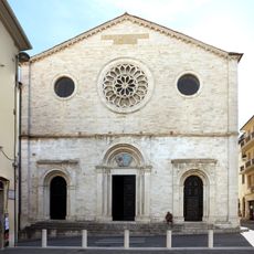
The Cathedral of San Benedetto and many churches contain religious artworks and frescoes by local artist Matteo da Gualdo that you can see while walking through the old streets. These works are woven into the daily life and appearance of the town center.
The railway station offers direct connections to Rome and Ancona with journey times of approximately two hours and one hour forty-five minutes respectively. The town's location in Umbria makes it a convenient base for exploring the surrounding region.
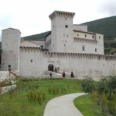
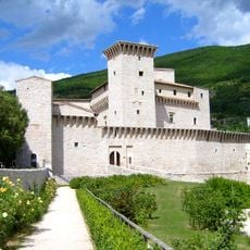
The Rocca Flea fortress dates to the 12th century and was restored by Frederick II in 1247, now housing a municipal museum with ancient ceramics and archaeological artifacts. Few visitors realize how much the fortress's restoration reflects medieval strategies for controlling the hilltop settlement.
The community of curious travelers
AroundUs brings together thousands of curated places, local tips, and hidden gems, enriched daily by 60,000 contributors worldwide.