Tanagura

Log in to your account

AroundUs is a community-driven map of interesting places, built by curious explorers like you. It grows with every review, story, and photo you share.
Connect to save your favorite spots, contribute locations, and create personalized routes.
Continue with Google
Continue with Apple
Continue with X
Continue with Facebook
Continue with email
By continuing, you accept our Terms and Conditions and our Privacy Policy
Create an account
Add to collection
Map
Suggest a change
Share

Tanagura, Rural town in Higashishirakawa district, Fukushima Prefecture, Japan

Tanagura is a rural municipality in southern Fukushima characterized by mountains and river valleys that shape the landscape. The Yamizosan mountain and the Kuji River are natural features that define its geography and the way communities settle across the terrain.

The area was part of the Tanagura Domain during the Edo period under feudal rule. It was officially recognized as a town in 1889, with a major expansion occurring through territorial annexation in 1950.

The town maintains sister city relationships with Sparta, Greece, and Lake Macquarie, Australia, creating ongoing cultural exchanges and connections between communities. These partnerships bring residents together through shared events and mutual learning experiences.

The town is accessible via the JR East Suigun Line and National Routes 118 and 289, which connect to surrounding regions. Public transportation is limited, so having your own vehicle is helpful for exploring the area thoroughly.

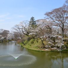
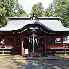
Two National Historic Sites are located here: the ruins of Tanagura Castle and the remains of Nagare Temple, preserving important archaeological heritage from different periods. These sites offer glimpses into the region's layered past and attract those interested in local history.

Location: Fukushima Prefecture

Location: Higashishirakawa district

Inception: April 1, 1889

Reference: 074811

Shares border with: Shirakawa, Asakawa, Yamatsuri, Hanawa, Samegawa, Otawara, Nasu, Daigo

Website: https://town.tanagura.fukushima.jp

GPS coordinates: 37.02986,140.37958

Latest update: December 20, 2025 12:39

Photos
Reviews

Visited this place? Tap the stars to rate it and share your experience / photos with the community! Try now! You can cancel it anytime.

« Tanagura - Rural town in Higashishirakawa district, Fukushima Prefecture, Japan » is provided by Around Us (aroundus.com). Images and texts are derived from Wikimedia project under a Creative Commons license. You are allowed to copy, distribute, and modify copies of this page, under the conditions set by the license, as long as this note is clearly visible.

Discover hidden gems everywhere you go!

From secret cafés to breathtaking viewpoints, skip the crowded tourist spots and find places that match your style. Our app makes it easy with voice search, smart filtering, route optimization, and insider tips from travelers worldwide. Download now for the complete mobile experience.

Around Us App Screenshot

A unique approach to discovering new places

Le Figaro

All the places worth exploring

France Info

A tailor-made excursion in just a few clicks

20 Minutes