Geography of Mongolia, Geographic region between China and Russia.
Mongolia is a geographic region between China and Russia with vast terrain spanning mountains, plateaus, and steppes across its interior. The landscape consists of highland areas, river valleys, and grasslands that vary dramatically from west to east and north to south.
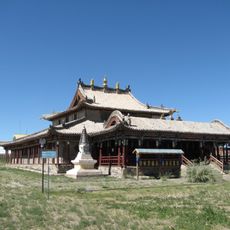
The region served as the core of a vast empire during the 13th century Mongol expansion, reaching across Asia and toward Europe. Following that era, geographic isolation and harsh environmental conditions shaped distinct settlement patterns and cultural developments in different areas.
Nomadic communities across the country practice seasonal herding, moving their camps and animals between highland pastures and lower valleys as weather patterns shift throughout the year.
The country experiences extreme temperature swings, often shifting dramatically between day and night, which affects what to pack for any visit. Remote regions have limited facilities and services, so visitors should prepare accordingly for self-sufficiency when traveling through interior areas.
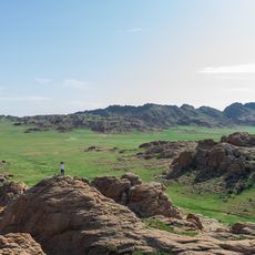
Stone carvings and burial mounds scattered across the western mountains reveal traces of ancient peoples who inhabited these plateaus during different epochs. These archaeological remains demonstrate how communities adapted to mountainous environments over thousands of years despite harsh conditions.
The community of curious travelers
AroundUs brings together thousands of curated places, local tips, and hidden gems, enriched daily by 60,000 contributors worldwide.