Loonse en Drunense Duinen National Park

Log in to your account

AroundUs is a community-driven map of interesting places, built by curious explorers like you. It grows with every review, story, and photo you share.
Connect to save your favorite spots, contribute locations, and create personalized routes.
Continue with Google
Continue with Apple
Continue with X
Continue with Facebook
Continue with email
By continuing, you accept our Terms and Conditions and our Privacy Policy
Create an account
Add to collection
Map
Suggest a change
Share

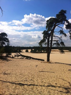
Loonse en Drunense Duinen National Park, Protected sand drift area in Noord-Brabant, Netherlands.

Loonse en Drunense Duinen National Park is a protected area with extensive sand dunes, pine forests, and heathland in the province of Noord-Brabant. The area lies between the towns of Loon op Zand, Drunen, and Udenhout, covering roughly 3,500 hectares (8,650 acres) of open and forested landscape.

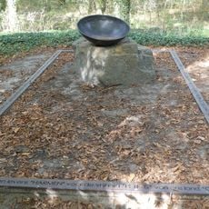
During the Middle Ages, intensive grazing and peat extraction led to the formation of an open sandy landscape that evolved into the current dune fields over the centuries. In the Second World War, German occupation forces used parts of the area for ammunition storage and several resistance fighters were executed here.

In winter, flocks of fieldfares fly over the dunes, while in summer nightjars let their churring call be heard at dusk. Walkers occasionally encounter sheep grazing on the heath areas, helping to keep the landscape open.

Eight entrance points allow access from different directions, with five leading directly to the open sand areas. Several entrances have parking facilities, bicycle rental options, and small cafes where you can take a break before or after walking.

The temperature in the sand can reach 40 degrees Celsius (104 degrees Fahrenheit) on summer days, while it drops to near freezing at night, creating distinct microclimates. These extreme variations shape conditions that only a few plants and animals can survive.

Location: Heusden

Inception: 2002

Website: http://np-deloonseendrunenseduinen.nl

GPS coordinates: 51.64778,5.11472

Latest update: December 5, 2025 22:30

Photos
Around this place
Netherlands

Van Gogh National Park

770 m
Kasteel van Loon op Zand
Netherlands

Kasteel van Loon op Zand

3.8 km
Sint-Jans Onthoofdingkerk, Loon op Zand
Netherlands

Sint-Jans Onthoofdingkerk, Loon op Zand

3.7 km
Watertoren Udenhout Vincentius
Netherlands

Watertoren Udenhout Vincentius

4.2 km
Molen van der Wouw
Netherlands

Molen van der Wouw

3.4 km
Woonstalhuis in Eclectische stijl
Netherlands

Woonstalhuis in Eclectische stijl

4.2 km
Kasteel Loon op Zand: brug
Netherlands

Kasteel Loon op Zand: brug

3.8 km
Villa Wilgenwind
Netherlands

Villa Wilgenwind

4.3 km
Giersbergen 2a, Drunen
Netherlands

Giersbergen 2a, Drunen

2.6 km
Kasteel Loon op Zand: tuinhuisje en grachthuisje
Netherlands

Kasteel Loon op Zand: tuinhuisje en grachthuisje

3.8 km
Schoorstraat 23, Udenhout
Netherlands

Schoorstraat 23, Udenhout

3.9 km
Oranjeplein 1, Loon op Zand
Netherlands

Oranjeplein 1, Loon op Zand

3.7 km
Boerderij met dwarshuis en langsdeel onder rieten wolfdak. Kruiskozijn met onderluiken
Netherlands

Boerderij met dwarshuis en langsdeel onder rieten wolfdak. Kruiskozijn met onderluiken

1.5 km
Strijdhoef: inrijhek
Netherlands

Strijdhoef: inrijhek

3.9 km
Kasteel Loon op Zand: bouwhuizen en grachtmuur
Netherlands

Kasteel Loon op Zand: bouwhuizen en grachtmuur

3.8 km
Woonhuis
Netherlands

Woonhuis

4.2 km
Woonhuis
Netherlands

Woonhuis

4.3 km
Strijdhoef: tuinkoepel
Netherlands

Strijdhoef: tuinkoepel

3.8 km
Strijdhoef: toegang tot het omgrachte voorplein van het huis, bestaande uit een dam met ijzeren paaltjes en kettingen en een bakstenen poortgebouw. Kasteel de Strijdhoef
Netherlands

Strijdhoef: toegang tot het omgrachte voorplein van het huis, bestaande uit een dam met ijzeren paaltjes en kettingen en een bakstenen poortgebouw. Kasteel de Strijdhoef

3.8 km
Strijdhoef: drie natuurstenen borstbeelden
Netherlands

Strijdhoef: drie natuurstenen borstbeelden

3.9 km
Boerderij "Vogelzang" met middenlangsdeel en langgevel-woonhuis
Netherlands

Boerderij "Vogelzang" met middenlangsdeel en langgevel-woonhuis

4.2 km
Huize Vincentius
Netherlands

Huize Vincentius

4.2 km
Kasteel Loon op Zand: parkaanleg
Netherlands

Kasteel Loon op Zand: parkaanleg

3.8 km
Strijdhoef
Netherlands

Strijdhoef

3.9 km
Groenstraat 90, Udenhout
Netherlands

Groenstraat 90, Udenhout

4.2 km
Kasteel Loon op Zand: tuinmuur met hek
Netherlands

Kasteel Loon op Zand: tuinmuur met hek

3.8 km
Boerderij van het langgeveltype met combinatie van dwars- en langdeel
Netherlands

Boerderij van het langgeveltype met combinatie van dwars- en langdeel

4.2 km
Oorlogsmonument
Netherlands

Oorlogsmonument

1.4 km
Show the full map
Reviews

Visited this place? Tap the stars to rate it and share your experience / photos with the community! Try now! You can cancel it anytime.

« Loonse en Drunense Duinen National Park - Protected sand drift area in Noord-Brabant, Netherlands » is provided by Around Us (aroundus.com). Images and texts are derived from Wikimedia project under a Creative Commons license. You are allowed to copy, distribute, and modify copies of this page, under the conditions set by the license, as long as this note is clearly visible.

Discover hidden gems everywhere you go!

From secret cafés to breathtaking viewpoints, skip the crowded tourist spots and find places that match your style. Our app makes it easy with voice search, smart filtering, route optimization, and insider tips from travelers worldwide. Download now for the complete mobile experience.

Around Us App Screenshot

A unique approach to discovering new places

Le Figaro

All the places worth exploring

France Info

A tailor-made excursion in just a few clicks

20 Minutes