Enable Location

We need your location to show you interesting places around you

Discover nearby places

Find interesting locations and hidden gems around you

Precise directions

Get accurate directions and distances to places

Your location is never shared with other users. It's only used when you tap the location button.

Haringvliet

Log in to your account

Start exploring — it's free

Trusted by 63,158 travelers worldwide

Continue with Google
Continue with Apple
or

We will send you a code to connect

By continuing, you accept our Terms and Conditions and our Privacy Policy

Check your inbox

We've sent a pincode in your inbox. Please enter the code below.

Discussion Reviews 1 Photos
9.9k Popularity

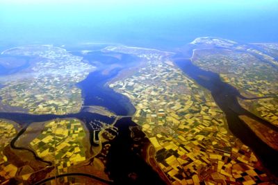
Haringvliet, Nature reserve and Ramsar site in South Holland, Netherlands

The Haringvliet is an expansive estuary in South Holland that forms part of the Rhine-Meuse delta system with a complex structure. It includes islands, reed beds, and open water areas that support diverse habitats and ecological functions.

Until 1970, the water held brackish conditions that shaped its ecosystem, but the construction of the Haringvliet locks changed that dramatically. This transformation redirected water flow and fundamentally altered which species could thrive there.

The area has long been shaped by fishing and reed harvesting, practices that visitors can still observe today shaping the landscape. These traditional activities remain woven into daily life around the estuary.

An information center on Tiengemeten Island provides educational resources about the local wetland and its wildlife. Access to the area is typically by water routes or designated landing points along the shoreline.

The site attracts thousands of waterfowl including spoonbills and terns that gather in large seasonal flocks. These migrating birds use this place as a critical rest stop on their long journeys between Africa and Scandinavia.

The community of curious travelers

AroundUs brings together thousands of curated places, local tips, and hidden gems, enriched daily by 60,000 contributors worldwide.

Start exploring
Location
Inception
2000
Operator
Rijkswaterstaat;Staatsbosbeheer;Natuurmonumenten
Part of
Rhine–Meuse–Scheldt delta
GPS coordinates
51.77167,4.21583
Latest update
December 10, 2025 15:56
Reviews
Share your experience

No review yet

Discussions
Start a discussion...

No discussion yet

« Haringvliet - Nature reserve and Ramsar site in South Holland, Netherlands » is provided by Around Us (aroundus.com). Images and texts are derived from Wikimedia project under a Creative Commons license. You are allowed to copy, distribute, and modify copies of this page, under the conditions set by the license, as long as this note is clearly visible.

Discover hidden gems everywhere you go!

From secret cafés to breathtaking viewpoints, skip the crowded tourist spots and find places that match your style. Our app makes it easy with voice search, smart filtering, route optimization, and insider tips from travelers worldwide. Download now for the complete mobile experience.

Around Us App Screenshot

A unique approach to discovering new places

Le Figaro

All the places worth exploring

France Info

A tailor-made excursion in just a few clicks

20 Minutes

Around Us
Travel Guide & Maps
Download

Send to your phone

QR Code
1

Open the camera app on your mobile.

2

Point at the QR code with your camera. A notification will appear.

3

Tap the notification to open the link.