Hagestein weir-lock complex

Log in to your account

AroundUs is a community-driven map of interesting places, built by curious explorers like you. It grows with every review, story, and photo you share.
Connect to save your favorite spots, contribute locations, and create personalized routes.
Continue with Google
Continue with Apple
Continue with X
Continue with Facebook
Continue with email
By continuing, you accept our Terms and Conditions and our Privacy Policy
Create an account

Hagestein weir-lock complex

Add to collection
Map
Suggest a change
Share

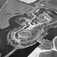
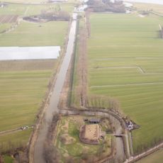
Hagestein weir-lock complex, Water management complex in Hagestein, Netherlands.

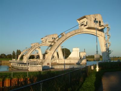
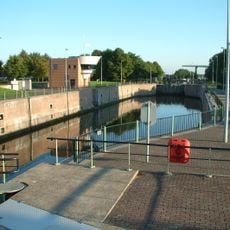
The Hagestein weir-lock complex in Vianen sits on the Lek River and combines two separate structures for water control and vessel passage. The weir and lock system work together to regulate water levels and provide boats with different routes depending on water conditions.

Built in 1960, the complex was part of a post-war program to modernize river control systems on the Nederrijn and Lek. It represents how the country rebuilt its water management infrastructure during that reconstruction period.

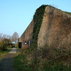
The complex showcases Dutch functionalist design by architect Wouter Hamdorff and carries national monument status. Its straightforward, practical form reflects how the country has always approached engineering as visible public art.

When water levels rise, vessels can pass directly under the open weir, but during low water conditions they must use the lock instead. Watching these different operating phases from the riverbank shows how water management changes with the seasons.

A hydroelectric power station sits inside the weir's central pillar, generating electricity while regulating water levels. This dual function shows how Dutch engineers combined multiple purposes into a single structure.

Location: Vianen

Inception: 1960

Architects: Wouter Hamdorff

Architectural style: functionalism, reconstruction-period architecture

Part of: Beschermingsprogramma Wederopbouw 1959-1965

Address: Lekdijk bij 7 te Hagestein

GPS coordinates: 51.99111,5.13333

Latest update: December 11, 2025 18:01

Photos
Around this place
Fort Honswijk
Netherlands

Fort Honswijk

2.5 km
Kasteel Hagestein
Netherlands

Kasteel Hagestein

1.2 km
Hagesteinsebrug
Netherlands

Hagesteinsebrug

1.7 km
Grote sluis Vianen
Netherlands

Grote sluis Vianen

2.5 km
Werk aan de Korte Uitweg
Netherlands

Werk aan de Korte Uitweg

1.9 km
Werk aan de Waalse Wetering
Netherlands

Werk aan de Waalse Wetering

1.4 km
Blasenburg
Netherlands

Blasenburg

1.2 km
Inundatiekanaal naar Fort Honswijk
Netherlands

Inundatiekanaal naar Fort Honswijk

2.1 km
Hervormde kerk
Netherlands

Hervormde kerk

1.2 km
Michaëlschool
Netherlands

Michaëlschool

2.1 km
Hervormde Kerk. Zaalkerkje met driezijdige sluiting. Tot de inventaris behoort: een gotische, hardstenen doopvont, gebruikt als voet voor de preekstoel. Preekstoel
Netherlands

Hervormde Kerk. Zaalkerkje met driezijdige sluiting. Tot de inventaris behoort: een gotische, hardstenen doopvont, gebruikt als voet voor de preekstoel. Preekstoel

1.5 km
Waalseweg 85, Tull en 't Waal
Netherlands

Waalseweg 85, Tull en 't Waal

1.5 km
Snellesteyn
Netherlands

Snellesteyn

1.9 km
Inundatiekanaal
Netherlands

Inundatiekanaal

2.2 km
In het pand of op de grens van het erf bevindende stadsmuur(resten)
Netherlands

In het pand of op de grens van het erf bevindende stadsmuur(resten)

2.6 km
In het pand of op de grens van het erf bevindende stadsmuur(resten)
Netherlands

In het pand of op de grens van het erf bevindende stadsmuur(resten)

2.6 km
Dorpsstraat 25, Hagestein
Netherlands

Dorpsstraat 25, Hagestein

1.4 km
In het pand of op de grens van het erf bevindende stadsmuur(resten)
Netherlands

In het pand of op de grens van het erf bevindende stadsmuur(resten)

2.6 km
Deels gepleisterde boerderij, onder rieten zadeldak
Netherlands

Deels gepleisterde boerderij, onder rieten zadeldak

760 m
Lekdijk 84, Hagestein
Netherlands

Lekdijk 84, Hagestein

2.2 km
Nederlands Hervormde Kerk
Netherlands

Nederlands Hervormde Kerk

1.5 km
Lunet de Snel
Netherlands

Lunet de Snel

2.4 km
Werk aan de Waalse Wetering
Netherlands

Werk aan de Waalse Wetering

1.3 km
In het pand of op de grens van het erf bevindende stadsmuur(resten)
Netherlands

In het pand of op de grens van het erf bevindende stadsmuur(resten)

2.7 km
Werk aan de Korte Uitweg: aardwerk
Netherlands

Werk aan de Korte Uitweg: aardwerk

1.9 km
Werk aan de Korte Uitweg: De Staat
Netherlands

Werk aan de Korte Uitweg: De Staat

1.9 km
Toren. Bakstenen bouwwerk, versierd tegen de onderste geledingen met tand- en boogfriezen in romaniserende trant
Netherlands

Toren. Bakstenen bouwwerk, versierd tegen de onderste geledingen met tand- en boogfriezen in romaniserende trant

1.5 km
Werk aan de Waalse Wetering
Netherlands

Werk aan de Waalse Wetering

1.4 km
Show the full map
Reviews

Visited this place? Tap the stars to rate it and share your experience / photos with the community! Try now! You can cancel it anytime.

« Hagestein weir-lock complex - Water management complex in Hagestein, Netherlands » is provided by Around Us (aroundus.com). Images and texts are derived from Wikimedia project under a Creative Commons license. You are allowed to copy, distribute, and modify copies of this page, under the conditions set by the license, as long as this note is clearly visible.

Discover hidden gems everywhere you go!

From secret cafés to breathtaking viewpoints, skip the crowded tourist spots and find places that match your style. Our app makes it easy with voice search, smart filtering, route optimization, and insider tips from travelers worldwide. Download now for the complete mobile experience.

Around Us App Screenshot

A unique approach to discovering new places

Le Figaro

All the places worth exploring

France Info

A tailor-made excursion in just a few clicks

20 Minutes