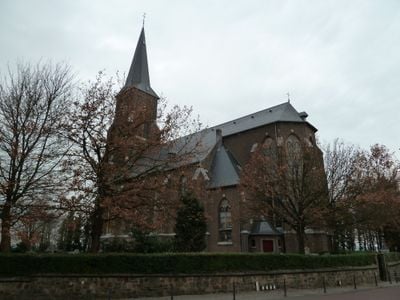
Sint-Martinuskerk, Church building in Vijlen, Netherlands
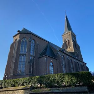
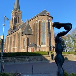
Sint-Martinuskerk is a church standing on Vijlenberg hill and rising prominently above the surrounding landscape. Its 65-meter tower is visible from a distance and shapes the character of the Vijlen area.
The church was designed by architect Carl Weber from 1860 and replaced a medieval structure that previously stood on the site. Construction stretched until 1879 due to financial difficulties that slowed the work.
The church displays neo-gothic architecture in the Lower Rhine Gothic style with three naves beneath a continuous roof. Visitors notice how the Stufenhalle arrangement shapes the interior space and distributes light in a distinctive way.
The church is easy to reach from the main road running through the village, and a cemetery surrounded by natural stone walls encloses the grounds. The elevated location offers good views over the village and surrounding region.
The church sits at one of the highest elevations in the region and ranks among the highest-situated religious buildings in the country. This position was deliberately chosen to give the structure presence and visibility.
Location: Vaals
Inception: 1860s
Architects: Carl Weber
Elevation above the sea: 195.62 m
Address: Vijlenberg 72
GPS coordinates: 50.78774,5.96314
Latest update: December 14, 2025 18:03
Harles
1.1 km
Hoeve Mamelis
1.3 km
Schoeërmolen
1.4 km
Vijlenstraat 57, Vijlen
204 m
Mamelis 37, Lemiers
1.3 km
Hilleshagerweg 122, Mechelen
1.3 km
Groenenweg 18, Vijlen
868 m
Groenenweg 16, Vijlen
850 m
Munnikenhof
328 m
Mamelis 29, Lemiers
1.3 km
Mamelis 35, Lemiers
1.3 km
Hopschet 16, Vijlen
181 m
Harles 12, Vijlen
1.3 km
Harles 15, Vijlen
1.2 km
Vijlenstraat 53, Vijlen
219 m
Harles 22, Vijlen
911 m
Rott 14, Vijlen
973 m
Harles 18, Vijlen
1.1 km
Hopschet 22, Vijlen
198 m
Vijlenberg 131, Vijlen
41 m
Mamelisserweg 3, Lemiers
1.2 km
Vijlenberg 123, Vijlen
51 m
Rott 36, Vijlen
1.2 km
Area with traces of a building and habitation south of Oude Trichterweg near Lemiers
1.1 km
Vijlenerstraat 18, Vijlen
518 m
Area with foundations of a building and traces of habitation south of Mamelis
984 m
Harles 9, Vijlen
1.3 km
Vakwerkhoeve (gesloopt), staat nu nieuwbouw
754 mVisited this place? Tap the stars to rate it and share your experience / photos with the community! Try now! You can cancel it anytime.
Discover hidden gems everywhere you go!
From secret cafés to breathtaking viewpoints, skip the crowded tourist spots and find places that match your style. Our app makes it easy with voice search, smart filtering, route optimization, and insider tips from travelers worldwide. Download now for the complete mobile experience.
A unique approach to discovering new places❞
— Le Figaro
All the places worth exploring❞
— France Info
A tailor-made excursion in just a few clicks❞
— 20 Minutes