Osdalssjøhøgda, protected area in Norway (Naturbase code: VV00001843)
Location: Rendalen Municipality
GPS coordinates: 61.63333,11.68333
Latest update: November 10, 2025 08:28

Osdalen
7.7 km
Skarvberget og Tallåsen
18.4 km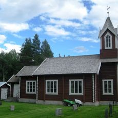
Søre Elvdal Church
6.7 km
Gammelkvernhusfossen
18 km
Skorbekklia
18.4 km
Nystufossen
18.1 km
Kvannhullfossen
17.2 km
Vamåsen
17.3 km
Lekjenndalen
15.5 km
Elvsæterfossen
14.3 km
Elvbrufossen
16 km
Fjellkroken
5.8 km
Høgfjellet
10.7 km
Sagbekkskåra
19.6 km
Skjerbekkraudkollen og Løvåskampen
9.8 km
Munkbetsætra
5.6 km
Hollfossen
19.1 km
Fløtfossen
16.9 km
Storhøa
13.5 km
Ånesteinen
6.1 km
Kvitvordaknappen
18.4 km
Nordre Kvitvolaknappen
18.8 km
Tuft
18.3 km
Elvbrufossen
16 km
Gammelkvernhusfossen
17.9 km
Elvsæterfossen
14.3 km
Fløtfossen
16.9 km
Skardbekkstupen
18.7 kmReviews
Visited this place? Tap the stars to rate it and share your experience / photos with the community! Try now! You can cancel it anytime.
Discover hidden gems everywhere you go!
From secret cafés to breathtaking viewpoints, skip the crowded tourist spots and find places that match your style. Our app makes it easy with voice search, smart filtering, route optimization, and insider tips from travelers worldwide. Download now for the complete mobile experience.

A unique approach to discovering new places❞
— Le Figaro
All the places worth exploring❞
— France Info
A tailor-made excursion in just a few clicks❞
— 20 Minutes