Jerta, Berggipfel in Norwegen
Location: Målselv Municipality
Elevation above the sea: 540 m
GPS coordinates: 68.69630,19.87070
Latest update: November 8, 2025 22:49
Øvre Dividal National Park
4.3 km
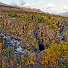
Dividalen
9.1 km
Likkájiehkki
25.7 km
Høgskartinden
22.3 km
Øvre Divifoss
6.4 km
Astujeaggi
23.7 km
Nedre Divifossen
18.5 km
Buoššir
17.4 km
Brennskoglia
22.8 km
Spállogasgorži
25 km
Borjjasoaivi
16.1 km
Sanddalen
16.5 km
Spállogasgorŋi
25 km
Lakko (tumoy sa bukid)
26.4 km
Gambekken v/Finnbruene
6.2 km
Stuorra Tuoipal
16.3 km
Liggavarri
26.4 km
Ligga
24.9 km
Lakkučåk'ka
27.9 km
Moarsejávri
12 km
Dreggfjellet
12.1 km
Forråd - depot
14.2 km
Riidagier'do
26.9 km
Jerta
4 km
Karesuando 520:1
16.6 km
Nedre Divifossen
18.5 km
Øvre Divifoss
6.4 km
Spállogasgorži
24.9 kmReviews
Visited this place? Tap the stars to rate it and share your experience / photos with the community! Try now! You can cancel it anytime.
Discover hidden gems everywhere you go!
From secret cafés to breathtaking viewpoints, skip the crowded tourist spots and find places that match your style. Our app makes it easy with voice search, smart filtering, route optimization, and insider tips from travelers worldwide. Download now for the complete mobile experience.

A unique approach to discovering new places❞
— Le Figaro
All the places worth exploring❞
— France Info
A tailor-made excursion in just a few clicks❞
— 20 Minutes