Såtbakkleiva, جرف في النرويج
Location: Sunndal Municipality
Elevation above the sea: 1,000 m
GPS coordinates: 62.65351,8.80878
Latest update: November 15, 2025 06:34
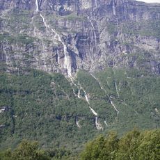
Vinnufossen
7.2 km
Dronningkrona
9.6 km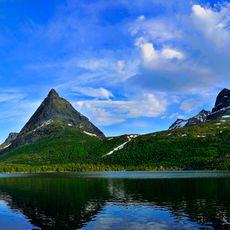
Innerdalen
5.2 km
Vinnufonna
7.8 km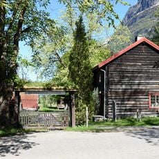
Sunndal bygdemuseum
6.1 km
Knutsliøya
3.1 km
Kaldfonna
7.2 km
Haremdalsfalla
10.8 km
Nonshøa
11.2 km
Musgjerd kirkested
11 km
Sesshjellen
6.6 km
Løykja
5.7 km
Storsalen nordtoppen
5.2 km
Scenic viewpoint
11.4 km
Nonshøa
11.2 km
Fremre Grynningshøa
11.6 km
Skardnebba
12 km
Scenic viewpoint
9.7 km
Øver Løkhammarn
7.1 km
Bjøråskaret
9.8 km
Skigardsbekken
11.7 km
Scenic viewpoint
11.9 km
Vinnufossen
7.1 km
Haremdalsfalla
10.8 km
Vinnufossen
7.1 km
Vinnu
7.2 km
Storfalla
5.5 km
Småfalla
6 kmReviews
Visited this place? Tap the stars to rate it and share your experience / photos with the community! Try now! You can cancel it anytime.
Discover hidden gems everywhere you go!
From secret cafés to breathtaking viewpoints, skip the crowded tourist spots and find places that match your style. Our app makes it easy with voice search, smart filtering, route optimization, and insider tips from travelers worldwide. Download now for the complete mobile experience.

A unique approach to discovering new places❞
— Le Figaro
All the places worth exploring❞
— France Info
A tailor-made excursion in just a few clicks❞
— 20 Minutes