San Miguel, Municipality in Bulacan, Philippines
San Miguel is a municipality in Bulacan comprising 49 barangays spread across a wide area with predominantly flat terrain. The town sits in an agricultural zone near the Sierra Madre mountain range.
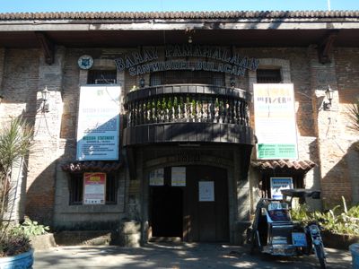
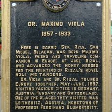
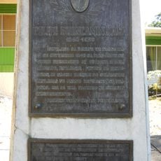
The area was founded in the late 1700s when an early settler established a community and gave the place its name. Later it became significant during a major uprising against colonial rule.
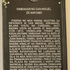
The community honors its patron saints through two major celebrations each year that shape the religious calendar and draw people together. These festivals reveal how faith remains woven into everyday life and local identity.
The area is best explored by walking or using local transportation since many parts of the town are spread out. It helps to ask locals for directions and information, especially when visiting historical sites or natural landmarks.
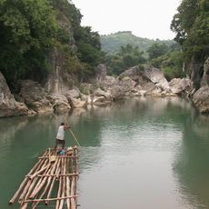
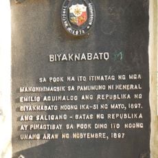
A cave complex on the town's territory served as a refuge during a fight for independence and remains a significant historical site today. Visitors can still access and explore these caves to understand this important chapter in local history.
Location: Bulacan
Inception: September 29, 1725
Elevation above the sea: 20 m
Shares border with: San Isidro, San Ildefonso
Address: 5292+GV, San Miguel, Bulacan, Philippines
GPS coordinates: 15.14583,120.97833
Latest update: December 6, 2025 22:04
Biak-na-Bato National Park
11.7 km
San Andres Apostol Church
17.2 km
San Juan de Dios Church
20.9 km
Sideco House
20.1 km
Santa Catalina Parish Church
22.1 km
Mariano Llanera historical marker
17.4 km
Dr. Maximo Viola historical marker
1.3 km
Big Rock Farm Resort
16.5 km
Bulacan Military Area historical marker
22.4 km
Jose P. Bantug historical marker
20.1 km
Biyaknabato historical marker
10.6 km
Battle of San Rafael historical marker
21 km
Trinidad Tecson historical marker
1.2 km
Mariano Ponce historical marker
22.5 km
Simon Tecson historical marker
1.1 km
Mamerto Natividad Jr. historical marker
17.4 km
Mariano Ponce Museum
22.5 km
Church of San Miguel de Mayumo historical marker
598 m
Felipe Buencamino, Sr. historical marker
234 m
San Rafael Elementary School historical marker
20.9 km
Long Live the Heroes historical marker
22.5 km
Epifanio de los Santos historical marker
19.7 km
Casa dela Fuente
19.7 km
Diosdado P. Macapagal historical marker
22 km
San Isidro historical marker
19.8 km
Dela Fuente–Villaroman Ancestral House historical marker
19.7 km
Battle of San Isidro historical marker
19.7 kmVisited this place? Tap the stars to rate it and share your experience / photos with the community! Try now! You can cancel it anytime.
Discover hidden gems everywhere you go!
From secret cafés to breathtaking viewpoints, skip the crowded tourist spots and find places that match your style. Our app makes it easy with voice search, smart filtering, route optimization, and insider tips from travelers worldwide. Download now for the complete mobile experience.
A unique approach to discovering new places❞
— Le Figaro
All the places worth exploring❞
— France Info
A tailor-made excursion in just a few clicks❞
— 20 Minutes