Biak-na-Bato National Park, National park in Bulacan, Philippines
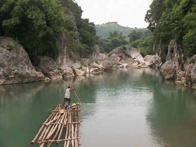
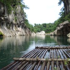
Biak-na-Bato National Park is a protected area in Bulacan, Philippines, covering a mountain gorge with cave systems, river passages, and walking paths in the Sierra Madre. The landscape consists of limestone rocks through which the Balaong River flows, surrounded by dense tropical forest.
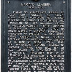
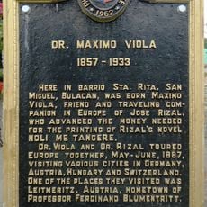
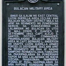
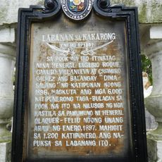
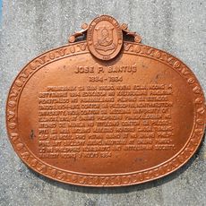
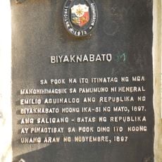
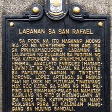
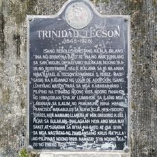
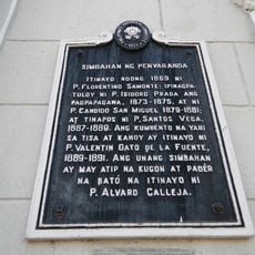
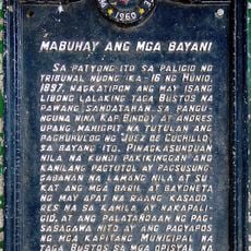
President Manuel Quezon declared this area a national park in 1937, recognizing its connection to the independence movement against Spanish rule. Revolutionary troops used the caves as a refuge and command post in the late 19th century during their campaign.
The name translates roughly to "split boulder" in Tagalog, referring to how the river carved through limestone formations. Local visitors often come to see the stone where revolutionary leaders signed their pact in 1897.
The area sits about 80 kilometers northeast of Manila and offers guided tours through several caves as well as walking paths through the gorge. Visiting is possible all year, though the dry season from November to May provides the best conditions.
More than one hundred caves run through the park area, many containing crystalline mineral formations. The Bahay Paniki system houses large bat colonies that emerge at dusk.
Location: Central Luzon
Location: Bulacan
Inception: 1989
GPS coordinates: 15.12010,121.08400
Latest update: December 5, 2025 22:29
Minalungao National Park
21.8 km
Angat Watershed Forest Reserve
22.2 km
San Juan de Dios Church
22.2 km
Sideco House
28.8 km
Saint Francis of Assisi Parish Church
27.4 km
Mariano Llanera historical marker
28.2 km
Dr. Maximo Viola historical marker
12.7 km
Big Rock Farm Resort
17.7 km
Bulacan Military Area historical marker
25.8 km
Battle of Kakarong historical marker
24.8 km
Jose P. Bantug historical marker
28.8 km
Biyaknabato historical marker
1.9 km
Battle of San Rafael historical marker
22.2 km
Trinidad Tecson historical marker
12 km
Simon Tecson historical marker
12.3 km
Mamerto Natividad Jr. historical marker
28.2 km
Church of San Miguel de Mayumo historical marker
11.7 km
Church of Peñaranda historical marker
27.4 km
Penyaranda historical marker
28.3 km
Felipe Buencamino, Sr. historical marker
11.5 km
Epifanio de los Santos historical marker
28.3 km
Long Live the Heroes historical marker
26.2 km
San Rafael Elementary School historical marker
21.9 km
Dreamwater Resort
28.1 km
Casa dela Fuente
22.3 km
San Isidro historical marker
28.4 km
Dela Fuente–Villaroman Ancestral House historical marker
22.3 km
Battle of San Isidro historical marker
28.4 kmReviews
Visited this place? Tap the stars to rate it and share your experience / photos with the community! Try now! You can cancel it anytime.
Discover hidden gems everywhere you go!
From secret cafés to breathtaking viewpoints, skip the crowded tourist spots and find places that match your style. Our app makes it easy with voice search, smart filtering, route optimization, and insider tips from travelers worldwide. Download now for the complete mobile experience.
A unique approach to discovering new places❞
— Le Figaro
All the places worth exploring❞
— France Info
A tailor-made excursion in just a few clicks❞
— 20 Minutes