El Nido, Coastal municipality in Palawan, Philippines
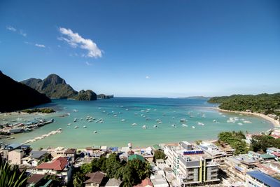
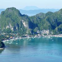
El Nido is a coastal municipality on the island of Palawan in the Philippines, spreading across dozens of islands with sand beaches and reefs. The landscape consists of limestone formations rising directly from the water and covered with tropical vegetation.
People lived here more than 4600 years ago, as finds in caves on the main island show. Spanish seafarers arrived in the 16th century and gave the settlement its current name.
The name comes from the Spanish word for swallow nest, which fishermen collected from the cliffs. People still make their living from the sea and preserve handcraft techniques for fishing and boat maintenance.
The small airport sits about 2.5 miles (4 km) outside the main town and connects the municipality with Manila. Boats depart daily to surrounding islands, with departure times depending on weather and tides.
Small birds build edible nests from their saliva in the steep rock faces, harvested for centuries. Collectors climb bamboo ladders into the caves to gather these nests for Asian cuisine.
Location: Palawan
Elevation above the sea: 35 m
Shares border with: Taytay, Linapacan
Website: http://elnidopalawan.gov.ph
GPS coordinates: 11.18004,119.39050
Latest update: December 4, 2025 19:05
The islands of the Philippines display exceptional geographical diversity. Palawan, Siargao, Boracay, Bohol, and Cebu offer beaches, coral reefs, clear water lagoons, and geological formations. The marine national parks host a rich marine fauna. Historical sites and terraced rice paddies represent cultural heritage. Volcanoes, waterfalls, and caves illustrate the variety of the archipelago's natural landscapes.
Puerto Princesa River
120.4 km
Puerto Princesa Subterranean River National Park
121.7 km
Fort Santa Isabel
41.6 km
Nacpan Beach
16.2 km
Secret Lagoon
9.3 km
Malampaya Sound Protected Landscape/Seascape
40.5 km
Hidden Beach
11.9 km
El Nido-Taytay Managed Resource Protected Area
8.2 km
Seven Commandos Beach
1.5 km
Malcapuya Island
104.3 km
Bulog Dos Island
105.2 km
Big Lagoon
8.1 km
Small Lagoon
8 km
Atwayan Beach
121.5 km
Matinloc Shrine
12.9 km
Talisay Beach
13.1 km
Nagkalit-kalit Waterfalls
9.9 km
Malcapuya Island Beach Resort
104 km
Ille Cave
12.8 km
Small Lagoon to Big Lagoon
7.9 km
Tres Verdes Beach Resort & Resto Bar
1.4 km
Secret Beach
12.5 km
Erawan Beach
60 km
Fort Santa Isabel historical marker
41.6 km
Ditaytayan Beach
99.5 km
Fort Culion historical marker
105.2 km
Secret Lagoon
9.3 km
Culion Leper Colony historical marker
105.1 kmReviews
Visited this place? Tap the stars to rate it and share your experience / photos with the community! Try now! You can cancel it anytime.
Discover hidden gems everywhere you go!
From secret cafés to breathtaking viewpoints, skip the crowded tourist spots and find places that match your style. Our app makes it easy with voice search, smart filtering, route optimization, and insider tips from travelers worldwide. Download now for the complete mobile experience.
A unique approach to discovering new places❞
— Le Figaro
All the places worth exploring❞
— France Info
A tailor-made excursion in just a few clicks❞
— 20 Minutes