·

Enable Location

We need your location to show you interesting places around you

Discover nearby places

Find interesting locations and hidden gems around you

Precise directions

Get accurate directions and distances to places

Your location is never shared with other users. It's only used when you tap the location button.

Log in to your account

Start exploring — it's free

Trusted by 62,708 travelers worldwide

Continue with Google
Continue with Apple
or

We will send you a code to connect

By continuing, you accept our Terms and Conditions and our Privacy Policy

Check your inbox

We've sent a pincode in your inbox. Please enter the code below.

Don Salvador Benedicto

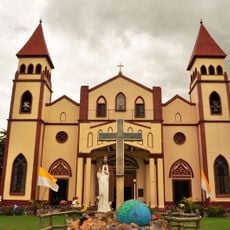
Don Salvador Benedicto, Mountain municipality in Negros Occidental, Philippines.

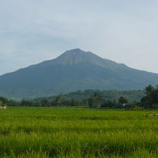
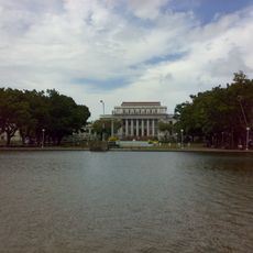
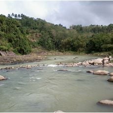
Don Salvador Benedicto is a mountain municipality comprising seven barangays spread across roughly 170 square kilometers with varying elevations. The landscape features mountain ridges and hillsides, while temperatures fluctuate based on altitude.

The municipality was founded in 1983 when federal law combined several remote barangays from neighboring regions. This act created a new administrative unit from portions of different older municipalities.

The seven barangays each maintain their own local traditions and agricultural methods passed down through generations. As you travel through the different villages, you notice distinct ways people work their land and shape their communities.

Access is provided via the Negros Translink Ecotourism Highway with bus connections from the south terminal in Bacolod City. Higher elevations can become slippery during rain, so sturdy footwear is advisable.

The region features rice terraces resembling those of Banaue and a magnetic hill where vehicles behave oddly on the road. Visitors report unusual gravity effects at this specific location along the SB13 road.

The community of curious travelers

AroundUs brings together thousands of curated places, local tips, and hidden gems, enriched daily by 60,000 contributors worldwide.

Start exploring
GPS coordinates
10.57618,123.21881
Latest update
December 10, 2025 15:52
Around this place
Kanlaon Volcano
Philippines

Kanlaon Volcano

20.6 km
The Ruins
Philippines

The Ruins

29.8 km
San Sebastian Cathedral
Philippines

San Sebastian Cathedral

31.5 km
Paglaum Sports Complex
Philippines

Paglaum Sports Complex

31.4 km
Capitol Park and Lagoon
Philippines

Capitol Park and Lagoon

31.3 km
Negros Occidental Provincial Capitol
Philippines

Negros Occidental Provincial Capitol

31.4 km
Negros Museum
Philippines

Negros Museum

31.4 km
Northern Negros Natural Park
Philippines

Northern Negros Natural Park

6.4 km
San Carlos Cathedral
Philippines

San Carlos Cathedral

24.3 km
Mariano Ramos Ancestral House
Philippines

Mariano Ramos Ancestral House

31 km
Cesar Lacson Locsin Ancestral House
Philippines

Cesar Lacson Locsin Ancestral House

36.3 km
Parco naturale del monte Kanla-on
Philippines

Parco naturale del monte Kanla-on

20.1 km
Acacia Hotel
Philippines

Acacia Hotel

32.1 km
Rizal Elementary School Building historical marker
Philippines

Rizal Elementary School Building historical marker

31.7 km
Graceland
Philippines

Graceland

14.3 km
Site where Spanish Forces Surrendered in Negros Occidental historical marker
Philippines

Site where Spanish Forces Surrendered in Negros Occidental historical marker

31.6 km
Vicente Conlu Montelibano Ancestral House
Philippines

Vicente Conlu Montelibano Ancestral House

36.3 km
Corazon Locsin Montelibano Memorial Regional Hospital historical marker
Philippines

Corazon Locsin Montelibano Memorial Regional Hospital historical marker

31.2 km
Capitol of Negros Occidental historical marker
Philippines

Capitol of Negros Occidental historical marker

31.4 km
Cesar Lacson Locsin Ancestral House historical marker
Philippines

Cesar Lacson Locsin Ancestral House historical marker

36.3 km
Soledad and Maria Montelibano Lacson Heritage House
Philippines

Soledad and Maria Montelibano Lacson Heritage House

36.3 km
Cathedral of Bacolod historical marker
Philippines

Cathedral of Bacolod historical marker

31.5 km
Ishiwata Bath House historical marker
Philippines

Ishiwata Bath House historical marker

14.5 km
Negros Occidental High School historical marker
Philippines

Negros Occidental High School historical marker

31.6 km
Vicente Conlu Montelibano Ancestral House historical marker
Philippines

Vicente Conlu Montelibano Ancestral House historical marker

36.3 km
Ishiwata Bath House
Philippines

Ishiwata Bath House

14.5 km
German Locsin Unson Ancestral House
Philippines

German Locsin Unson Ancestral House

36.3 km
Aniceto Lacson Ancestral House
Philippines

Aniceto Lacson Ancestral House

31.8 km
Show the full map
« Don Salvador Benedicto - Mountain municipality in Negros Occidental, Philippines » is provided by Around Us (aroundus.com). Images and texts are derived from Wikimedia project under a Creative Commons license. You are allowed to copy, distribute, and modify copies of this page, under the conditions set by the license, as long as this note is clearly visible.

Discover hidden gems everywhere you go!

From secret cafés to breathtaking viewpoints, skip the crowded tourist spots and find places that match your style. Our app makes it easy with voice search, smart filtering, route optimization, and insider tips from travelers worldwide. Download now for the complete mobile experience.

Around Us App Screenshot

A unique approach to discovering new places

Le Figaro

All the places worth exploring

France Info

A tailor-made excursion in just a few clicks

20 Minutes

Around Us
Travel Guide & Maps
Download

Send to your phone

QR Code
1

Open the camera app on your mobile.

2

Point at the QR code with your camera. A notification will appear.

3

Tap the notification to open the link.