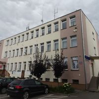
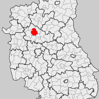
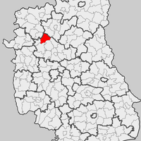
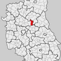
Lubartów County, Administrative district in Lublin Voivodeship, Poland.
Lubartów County is an administrative district in Lublin Voivodeship containing thirteen gminas and several rural settlements across eastern Poland. The landscape consists mainly of agricultural areas and smaller urban centers, with Lubartów serving as the administrative seat.
The district's current structure emerged from administrative reforms in 1999 when boundaries were redrawn and administrative organs reorganized. This reorganization was part of a broader decentralization process in Poland following the end of communist rule.
The county is shaped by farming traditions and local markets where handcrafted goods from surrounding villages are sold. These products reflect the rural lifestyle and the connection between residents and the land.
The region is well connected by local transportation networks linking the administrative seat with neighboring municipalities and providing access to schools and hospitals. Visitors should note that public transit between smaller villages is less frequent and having personal transport can be helpful.
The district contains several protected natural areas where visitors can observe native plant species and animals in their natural surroundings. These reserves play an important role in preserving the rural biodiversity of the region.
Location: Lublin Voivodeship
Capital city: Lubartów
Shares border with: Parczew County, Łęczna County, Lublin County, Puławy County, Ryki County, Łuków County, Radzyń County
Website: http://powiatlubartowski.pl
GPS coordinates: 51.46667,22.60000
Latest update: December 10, 2025 15:46
Saint Anne church in Lubartów
648 m
Saint Lawrence church in Lubartów
1.1 km
Mary Magdalene Church in Serniki
5.4 km
Jewish cementery in Lubartów
1.5 km
Market square in Lubartów
768 m
Muzeum Ziemi Lubartowskiej
759 m
Muzeum Parafialne w Lubartowie
648 m
Capuchin monastery in Lubartów
1.1 km
Cemetery chapel in Lubartów
494 m
Lubartów Palace
874 m
Zespół klasztorny kapucynów w Lubartowie
1.1 km
Stajnia koni roboczych
7.4 km
Cmentarz kościelny
5.5 km
Mary Magdalene Church in Serniki
5.4 km
28 Kościuszki Street in Lubartów
754 m
Dom, ob. budynek biurowy
786 m
3-5 Kościuszki Street in Lubartów
728 m
Brama, poł. XVIII
660 m
Mostek, poł. XVIII
677 m
Zespół kościoła Marii Magdaleny
5.4 km
Orangery in Lubartów
677 m
Dzwonnica w Sernikach
5.4 km
Pałac, Słowackiego 8 w Lubartowie
690 m
Ogrodzenie z bramkami
5.4 km
Ogrodzenie z bramką, poł. XVIII
620 m
Saint Anne church in Lubartów - belfry
643 m
Układ urbanistyczny miasta Lubartów
765 m
Plebania, Słowackiego 6 w Lubartowie
618 mVisited this place? Tap the stars to rate it and share your experience / photos with the community! Try now! You can cancel it anytime.
Discover hidden gems everywhere you go!
From secret cafés to breathtaking viewpoints, skip the crowded tourist spots and find places that match your style. Our app makes it easy with voice search, smart filtering, route optimization, and insider tips from travelers worldwide. Download now for the complete mobile experience.
A unique approach to discovering new places❞
— Le Figaro
All the places worth exploring❞
— France Info
A tailor-made excursion in just a few clicks❞
— 20 Minutes