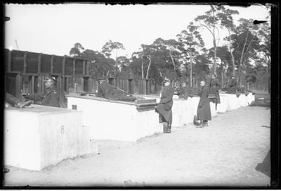
Fort I, 19th-century military fortification in Bielany district, Warsaw, Poland.
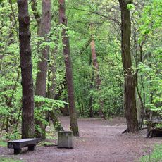
Fort I is a 19th-century military fortification in Warsaw composed of earth ramparts, brick walls, and a network of defensive ditches arranged in a polygonal configuration. The structure sits within parkland today, where visitors can still see remnants such as former stable buildings and underground passages.
The fort was built between 1883 and 1890 by the Russian Empire as part of a defensive system protecting Warsaw. It was one of approximately 20 structures in this strategic ring that surrounded the city.
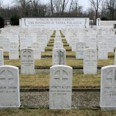
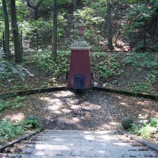
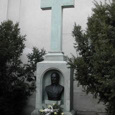
The Italian Military Cemetery on the grounds serves as a place of remembrance for soldiers who fell during the conflicts. Visitors encounter graves from different periods, which speak to the international scope of the wars that shaped this place.
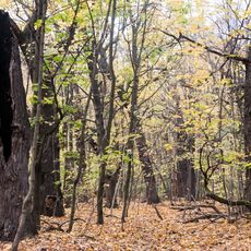
The site is accessible through the surrounding park and works well for a leisurely walk, especially if you are interested in historical structures. Spring and autumn offer the most pleasant conditions, as the weather is mild and the landscape shows the site to best advantage.
The fort was part of an outer defensive ring positioned about 8 kilometers from the city center to create a wide protective zone. Together with about 13 other brick structures, it formed a coordinated network meant to guard Warsaw from a distance.
GPS coordinates: 52.29810,20.94860
Latest update: December 14, 2025 09:44
Maria Skłodowska-Curie Bridge, Warsaw
1 km
Lasek Bielański
1 km
Brühl Palace
1.4 km
Italian Soldiers Cemetery in Warsaw
358 m
Camaldolese Church
824 m
Las Lindego
1.3 km
Biblioteka Główna Uniwersytetu Kardynała Stefana Wyszyńskiego
947 m
Kościół NMP Królowej Polski
1.6 km
Kościół Niepokalanego Poczęcia Najświętszej Maryi Panny w Warszawie
904 m
Immaculate Conception of the Blessed Virgin Mary Church in Warsaw
818 m
Erem eremitorium fundacji Jana Kazimierza (nr 10) - kancelaria parafialna
847 m
Obudowa źródła
914 m
Erem fundacji prymasa Macieja Łubieńskiego (nr 11)
864 m
Erem eremitorium fundacji Władysława IV, tzw. erem królewski (nr 9) - dom proboszcza
830 m
Grób Staszica
819 m
Erem fundacji podkanclerza litewskiego Kazimierza Leona Spiehy (nr 5)
872 m
Erem fundacji biskupa warmińskiego Krzysztofa Szembeka (nr 6)
889 m
Erem fundacji biskupa poznańskiego Andrzeja Szołdrskiego (nr 7)
860 m
Erem fundacji nieznanej, zapewne z herbem Poraj (nr 8)
875 m
Erem fundacji Gedeona Michała Tryzny (nr 3) - Wydział Polonistyki UKSW
868 m
Erem fundacji wielkiego kanclerza litewskiego Albrechta Stanisława Radziwiłła (nr 2) - księgarnia UKSW
852 m
Erem fundacji arcybiskupa gnieźnieńskiego Jana Stefana Wydżgi (nr 1) - stróżówka
819 m
Erem fundacji biskupa Karola Ferdynanda Wazy (nr 12)
879 m
Erem fundacji opata oliwskiego Stefana Hackiego (nr 13)
896 m
Budynki poklasztorne (oficyna kuchenna i oficyna)
839 m
Zespół klasztorny kamedułów
846 m
Erem fundacji kanclerza Jerzego Ossolińskiego (nr 4) - Sekretariat UKSW
856 m
Teren
846 mVisited this place? Tap the stars to rate it and share your experience / photos with the community! Try now! You can cancel it anytime.
Discover hidden gems everywhere you go!
From secret cafés to breathtaking viewpoints, skip the crowded tourist spots and find places that match your style. Our app makes it easy with voice search, smart filtering, route optimization, and insider tips from travelers worldwide. Download now for the complete mobile experience.
A unique approach to discovering new places❞
— Le Figaro
All the places worth exploring❞
— France Info
A tailor-made excursion in just a few clicks❞
— 20 Minutes