Góra Kamieńska, Artificial hill in Kamieńsk, Poland.
Góra Kamieńska is an artificial hill in central Poland that rises 405.6 meters above sea level, standing about 195 meters above the surrounding terrain. Its northeastern slope holds a sports center with illuminated ski slopes, a chairlift, and T-bar lifts, while the entire location is crisscrossed with cycling trails of varying difficulty.
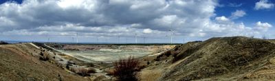
Construction of this artificial hill began in June 1977 using excavated material from the Bełchatów Lignite Mine and was completed in November 1993. The creation of this new landmark resulted from a major mining operation that significantly reshaped the region's landscape.
The name Góra Kamieńska was officially adopted in 1999 by the local city council as part of the town's growing identity. Today it serves as a focal point where residents and visitors gather for outdoor recreation and seasonal activities throughout the year.
In winter, the northeastern slopes offer ideal conditions for skiing and snowboarding with multiple lifts and illuminated runs for evening sessions. The location is easily accessible from the surrounding lowlands with well-marked access roads.
A wind turbine crowns the summit of this hill, generating power while serving as a distinctive landmark visible across the region. This blend of recreational use and renewable energy generation shows how former mining land can be transformed into something entirely new.
The community of curious travelers
AroundUs brings together thousands of curated places, local tips, and hidden gems, enriched daily by 60,000 contributors worldwide.