Chest opened
+${chestReward.xp} XP
Explorer
NOUVEAU ×${chestReward.collectible.quantity}
tapez pour fermer
Chest locked

Open chests in the app

Around Us is built for your phone — chests unlock when you walk, explore and capture nearby places.

Enable Location

We need your location to show you interesting places around you

Discover nearby places

Find interesting locations and hidden gems around you

Precise directions

Get accurate directions and distances to places

Your location is never shared with other users. It's only used when you tap the location button.

Log in to your account

Start exploring — it's free

Trusted by 72,876 travelers worldwide

Continue with Google
Continue with Apple
or

We will send you a code to connect

By continuing, you accept our Terms and Conditions and our Privacy Policy

Check your inbox

We've sent a pincode in your inbox. Please enter the code below.

Przysłop Miętusi
Discussion Reviews Photo
6.1k Popularity

Przysłop Miętusi, Mountain grassland in Kościelisko, Poland

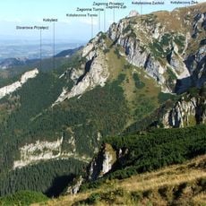
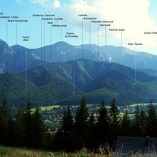
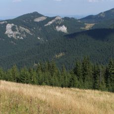
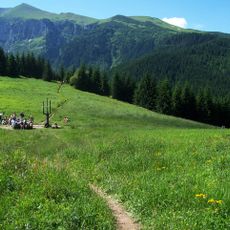
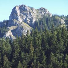
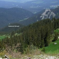
Przysłop Miętusi is a mountain grassland at 1189 meters elevation positioned between Kościeliska and Małej Łąki valleys, with panoramic views of Giewont and Czerwone Wierchy peaks on the horizon. The terrain slopes gently across open meadows bordered by forest edges, creating a clear sightline to the rocky red formation of Zadnia Kończysta Turnia to the southwest.

The name derives from the Wallachian term 'prislop' meaning mountain pass, reflecting the landscape's natural function as a transitional point. For centuries the land served as grazing territory and belonged to the Miętus family, from whom it took its name.

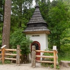
A metal cross erected in 1990 stands at the southern forest edge, honoring Pope John Paul II and his spiritual significance for Polish visitors. This monument transforms the grassland into a site where people come to reflect on faith and national identity.

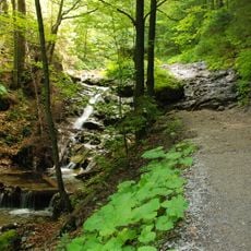
The ascent follows a red-marked trail starting from Nędzówka stop, with the walk covering around 3 kilometers and involving roughly 237 meters of elevation gain. You should budget approximately 90 minutes for the hike to reach the grassland under normal conditions.

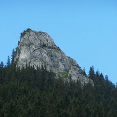
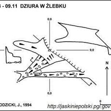
To the west lies Zadnia Kończysta Turnia, a red rock formation at 1296 meters that once served as an iron ore extraction site in earlier centuries. Though the mining activity has long ceased, this geological landmark still commands attention as a striking visual feature of the surrounding terrain.

The community of curious travelers

AroundUs brings together thousands of curated places, local tips, and hidden gems, enriched daily by 60,000 contributors worldwide.

Start exploring
Location
Kościelisko
GPS coordinates
49.26221,19.89185
Latest update
December 10, 2025 16:21
Reviews
Share your experience

No review yet

Discussions
Start a discussion...

No discussion yet

« Przysłop Miętusi - Mountain grassland in Kościelisko, Poland » is provided by Around Us (aroundus.com). Images and texts are derived from Wikimedia project under a Creative Commons license. You are allowed to copy, distribute, and modify copies of this page, under the conditions set by the license, as long as this note is clearly visible.

Discover hidden gems everywhere you go!

From secret cafés to breathtaking viewpoints, skip the crowded tourist spots and find places that match your style. Our app makes it easy with voice search, smart filtering, route optimization, and insider tips from travelers worldwide. Download now for the complete mobile experience.

Around Us App Screenshot

A unique approach to discovering new places

Le Figaro

All the places worth exploring

France Info

A tailor-made excursion in just a few clicks

20 Minutes

Around Us
Travel Guide & Maps
Download

Send to your phone

QR Code
1

Open the camera app on your mobile.

2

Point at the QR code with your camera. A notification will appear.

3

Tap the notification to open the link.