Chest opened
+${chestReward.xp} XP
Explorer
NOUVEAU ×${chestReward.collectible.quantity}
tapez pour fermer

See the monuments around you in AR Open chests in the app

Around Us is built for your phone — point your camera at the streets and discover the monuments and places around you in augmented reality. Around Us is built for your phone — chests unlock when you walk, explore and capture nearby places.

•

Enable Location

We need your location to show you interesting places around you

Discover nearby places

Find interesting locations and hidden gems around you

Precise directions

Get accurate directions and distances to places

Your location is never shared with other users. It's only used when you tap the location button.

Tyritake

Log in to your account

Start exploring — it's free

Trusted by 94,087 travelers worldwide

Continue with Google
Continue with Apple
or

We will send you a code to connect

By continuing, you accept our Terms and Conditions and our Privacy Policy

Check your inbox

We've sent a pincode in your inbox. Please enter the code below.

Tyritake, Archaeological site in Kerch, Ukraine

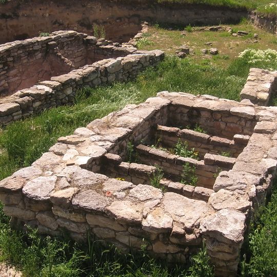
Tyritake is an ancient Greek town site on a high plateau in Kerch, about 11 km south of Panticapaeum. Its ruins include low walls of irregular light-beige and tan stones forming two adjoining rectangular chambers or basins, now filled with soil and small green plants. The settlement was founded by Ionian Greeks in the 6th century BC and later rebuilt with dozens of fish-salting vats.

Ionian Greeks founded Tyritake in the mid-6th century BC, and it became part of the Bosporan Kingdom. In the first centuries AD it was rebuilt around fishing and wine production, with about 30 fish-salting vats holding up to 1,600 quintals at a time. The Goths sacked it in the 3rd century AD and the Huns in the 4th, but a settlement continued into the Middle Ages.

The settlement was known for its craft workshops and fishing, which shaped daily life for residents. These economic activities remain visible in the artifacts and remains discovered during ongoing excavations.

Tyritake lies on a high plateau within Kerch's city limits, about 11 km south of the former Panticapaeum site, and the ground is uneven. Sections of the defensive walls, up to 2.5 m thick, and about 30 stone-lined fish-salting basins survive in the open. Wear sturdy shoes; there is little infrastructure on site.

Excavations at Tyritake uncovered about 30 fish-salting vats, in which up to 1,600 centners of fish could be salted at one time. The town was rebuilt in the first centuries AD with this trade as its mainstay. The Polish Archaeological Mission of the National Museum in Warsaw, directed by Alfred Twardecki, joined the project in 2008.

The community of curious travelers

AroundUs brings together thousands of curated places, local tips, and hidden gems, enriched daily by 94,087 contributors worldwide.

Start exploring
Location
Inception
6 century BCE
GPS coordinates
45.27706,36.40722
Latest update
October 29, 2026 06:28
Around this place
Russian Federation

Городище Нимфей (6в до н.э. - 3в н.э.)

2.8 mi
Russian Federation

Городище Тиритака (6в до н.э. - 3в н.э.)

50 ft
Russian Federation

Шарикоподшипник

1.9 mi
Russian Federation

Memorial

1.9 mi
Russian Federation

Братская могила партизан Старокарантинских каменоломен, 1941 г.

1.2 mi
Russian Federation

386 батальону морской пехоты

2.4 mi
Russian Federation

Якоря

0.5 mi
Ukraine

Набат памяти - памятный знак детям-жертвам войны

0.7 mi
Russian Federation

Братская могила советских воинов, 1941 г.

1.9 mi
Russian Federation

Братская могила моряков-десантников

2.8 mi
Russian Federation

Машнину Алексею Ивановичу

2.9 mi
Russian Federation

Памятник партизанам Старокарантинских каменоломен

2.5 mi
Russian Federation

Рыбакам рыбколхоза им. Ленина, погибшим 13 мая 1943 г

2 mi
Russian Federation

Стелла в честь командира Старокарантинского партизанского отряда Зябрева А. Ф.

2.3 mi
Russian Federation

Братская могила партизан и мирных жителей, 1943-44 гг.

1.9 mi
Russian Federation

Памятник Горькому

1.3 mi
Russian Federation

Памятник Горькому

1.2 mi
Russian Federation

Памятная доска жертвам расстрела в Камыш-Бурунском рве

0.7 mi
Russian Federation

Памяти камыш-бурунцев, павших за свободу и независимость Родины.

0.5 mi
Ukraine

Памятник кубанским казакам, погибшим в годы Великой Отечественной войны

0.3 mi
Ukraine

Памятник воинам-десантникам

0.3 mi
Russian Federation

Scenic viewpoint

2.3 mi
Russian Federation

Scenic viewpoint

1.8 mi

Городской пляж

1.8 mi
Russian Federation

Аршинцева коса

1.3 mi
Russian Federation

Пляж Залив

3 mi
Russian Federation

Sculpture

1.9 mi
Russian Federation

Братская могила советских воинов, 1943 г.

3.2 mi
Show the full map
Reviews
Share your experience

No review yet

Discussions
Start a discussion...

No discussion yet

« Tyritake - Archaeological site in Kerch, Ukraine » is provided by Around Us (aroundus.com). Images and texts are derived from Wikimedia project under a Creative Commons license. You are allowed to copy, distribute, and modify copies of this page, under the conditions set by the license, as long as this note is clearly visible.

Discover hidden gems everywhere you go!

From secret cafés to breathtaking viewpoints, skip the crowded tourist spots and find places that match your style. Our app makes it easy with voice search, smart filtering, route optimization, and insider tips from travelers worldwide. Download now for the complete mobile experience.

Around Us App Screenshot
❝

A unique approach to discovering new places❞

— Le Figaro

❝

All the places worth exploring❞

— France Info

❝

A tailor-made excursion in just a few clicks❞

— 20 Minutes

Around Us
Travel Guide & Maps
Download

Send to your phone

QR Code
1

Open the camera app on your mobile.

2

Point at the QR code with your camera. A notification will appear.

3

Tap the notification to open the link.