Geography of Sudan, Geographic region in Northeast Africa
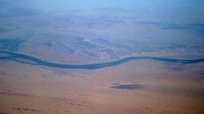
Sudan is a geographic region in Northeast Africa spanning vast plains and plateaus with the Nile River flowing through its eastern section from south to north. The land transitions from desert landscapes in the north to grassland areas in the south.
Medieval Arab geographers gave the territory its name, calling it bilād al-sūdān to describe settled African regions at the Sahara's southern edge. This designation reflected how the area was seen as a transition zone between the desert and sub-Saharan Africa.
The northern regions show Mediterranean and Arab influences, while the southern areas keep traditional African languages and customs due to their geographic separation.
Soil composition varies significantly across the country and influences farming methods used in each region. Northern areas feature sandy terrain, while central and southern zones have clay and laterite formations.
The Nubian Desert in the eastern part of the country stands out for having no oases at all. This unbroken expanse of stony ground and sandy dunes extends without any water sources.
The community of curious travelers
AroundUs brings together thousands of curated places, local tips, and hidden gems, enriched daily by 60,000 contributors worldwide.