Chest opened
+${chestReward.xp} XP
Explorer
NOUVEAU ×${chestReward.collectible.quantity}
tapez pour fermer
Chest locked

Open chests in the app

Around Us is built for your phone — chests unlock when you walk, explore and capture nearby places.

Enable Location

We need your location to show you interesting places around you

Discover nearby places

Find interesting locations and hidden gems around you

Precise directions

Get accurate directions and distances to places

Your location is never shared with other users. It's only used when you tap the location button.

North Riding of Yorkshire

Log in to your account

Start exploring — it's free

Trusted by 73,051 travelers worldwide

Continue with Google
Continue with Apple
or

We will send you a code to connect

By continuing, you accept our Terms and Conditions and our Privacy Policy

Check your inbox

We've sent a pincode in your inbox. Please enter the code below.

North Riding of Yorkshire
Discussion Reviews 1 Photos
51k Popularity

North Riding of Yorkshire, Historic administrative division in Yorkshire, England.

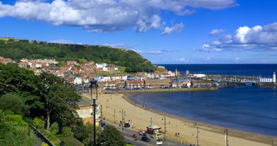
The North Riding of Yorkshire was a historic administrative region stretching from the North Sea coast to the Yorkshire Moors, encompassing towns like Middlesbrough, Scarborough, and Whitby. The area was governed from Northallerton until 1974, when it was dissolved and redistributed among North Yorkshire, Cleveland, and neighboring territories.

The area emerged in the 9th century under Scandinavian influence, when Yorkshire was divided into three parts; the name 'Riding' comes from the Old Norse word 'thridjungr', meaning 'third'. This administrative structure shaped the region for over a thousand years until 20th century reforms abolished the ancient boundaries.

The region followed ancient Norse patterns of organization that shaped how communities governed themselves. These administrative traditions still echo in modern district divisions and place names that reflect the medieval past.

The territory encompasses varied landscapes from coastal areas to moorlands, enabling different activities and exploration routes. Visitors should note that this is a historical administrative area whose original boundaries no longer appear on modern maps.

Mickle Fell, the highest point of this former region, rises above the moorlands and served long as a landmark for travelers and traders. The mountain sits on the boundaries of the old administrative area and still marks a natural watershed between different present-day districts.

The community of curious travelers

AroundUs brings together thousands of curated places, local tips, and hidden gems, enriched daily by 60,000 contributors worldwide.

Start exploring
Location
Part of
Yorkshire
Shares border with
West Riding of Yorkshire, East Riding of Yorkshire
GPS coordinates
54.33778,-1.42861
Latest update
December 14, 2025 18:25
Reviews
Share your experience

No review yet

Discussions
Start a discussion...

No discussion yet

« North Riding of Yorkshire - Historic administrative division in Yorkshire, England » is provided by Around Us (aroundus.com). Images and texts are derived from Wikimedia project under a Creative Commons license. You are allowed to copy, distribute, and modify copies of this page, under the conditions set by the license, as long as this note is clearly visible.

Discover hidden gems everywhere you go!

From secret cafés to breathtaking viewpoints, skip the crowded tourist spots and find places that match your style. Our app makes it easy with voice search, smart filtering, route optimization, and insider tips from travelers worldwide. Download now for the complete mobile experience.

Around Us App Screenshot

A unique approach to discovering new places

Le Figaro

All the places worth exploring

France Info

A tailor-made excursion in just a few clicks

20 Minutes

Around Us
Travel Guide & Maps
Download

Send to your phone

QR Code
1

Open the camera app on your mobile.

2

Point at the QR code with your camera. A notification will appear.

3

Tap the notification to open the link.