Enable Location

We need your location to show you interesting places around you

Discover nearby places

Find interesting locations and hidden gems around you

Precise directions

Get accurate directions and distances to places

Your location is never shared with other users. It's only used when you tap the location button.

Cavehill

Log in to your account

Start exploring — it's free

Trusted by 62,474 travelers worldwide

Continue with Google
Continue with Apple
or

We will send you a code to connect

By continuing, you accept our Terms and Conditions and our Privacy Policy

Check your inbox

We've sent a pincode in your inbox. Please enter the code below.

Cavehill

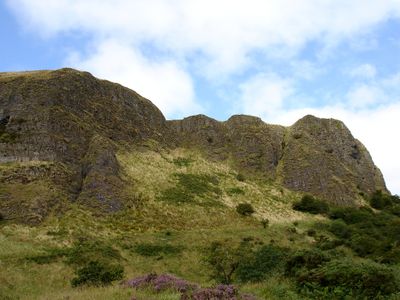
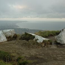
Cavehill, Basalt mountain summit in County Antrim, Northern Ireland.

Cavehill is a basalt mountain in County Antrim with a summit approximately 370 meters high and multiple caves within its structure. The mountain forms part of the extensive geological formation of the Antrim Plateau.

Archaeological finds show that the mountain was inhabited since the Stone Age, with Bronze Age traces including ringforts and stone cashels. These ancient structures indicate that the site held importance for human communities across millennia.

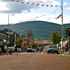
The mountain's distinctive outline, especially the formation called Napoleon's Nose, inspired Jonathan Swift when creating his literary work Gulliver's Travels. This recognizable shape has remained central to Belfast's identity and continues to hold meaning for those who live here.

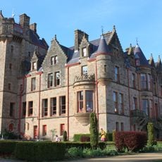
Multiple entry points with parking facilities exist at Belfast Castle, Belfast Zoo, and Upper Hightown Road. Trails are accessible at different difficulty levels, allowing visitors to choose routes based on fitness and preferences.

The mountain holds the designation of Site of Special Scientific Interest, recognizing its geological composition and diverse ecosystems with native Irish plants and animals. This protected status ensures the natural diversity of the place for future generations.

The community of curious travelers

AroundUs brings together thousands of curated places, local tips, and hidden gems, enriched daily by 60,000 contributors worldwide.

Start exploring
Location
Elevation above the sea
370 m
Made from material
basalt
Part of
plateau d'Antrim
GPS coordinates
54.64821,-5.95064
Latest update
December 7, 2025 10:05
Around this place
Titanic Belfast
United Kingdom

Titanic Belfast

5.2 km
Shankill Road
United Kingdom

Shankill Road

4.9 km
HM Prison Crumlin Road
United Kingdom

HM Prison Crumlin Road

4.4 km
Belfast Castle
United Kingdom

Belfast Castle

815 m
Belfast Zoo
United Kingdom

Belfast Zoo

1 km
Crumlin Road Courthouse
United Kingdom

Crumlin Road Courthouse

4.5 km
Clifton House
United Kingdom

Clifton House

4.8 km
HMS Caroline
United Kingdom

HMS Caroline

5 km
Alexandra Park, Belfast
United Kingdom

Alexandra Park, Belfast

3.6 km
Holy Cross Church, Ardoyne
United Kingdom

Holy Cross Church, Ardoyne

4.1 km
Dividers
United Kingdom

Dividers

5.1 km
HMS Caroline
United Kingdom

HMS Caroline

4.9 km
Duncairn Centre for Culture and Arts
United Kingdom

Duncairn Centre for Culture and Arts

4.1 km
William Conor statue
United Kingdom

William Conor statue

5 km
Railway Viaduct (1) Bleach Green Junction Newtownabbey Co Antrim Bt37
United Kingdom

Railway Viaduct (1) Bleach Green Junction Newtownabbey Co Antrim Bt37

4.8 km
Railway Viaduct (2) Bleach Green Junction Newtownabbey Co Antrim Bt37
United Kingdom

Railway Viaduct (2) Bleach Green Junction Newtownabbey Co Antrim Bt37

4.8 km
Chapel Of The Resurrection Innisfayle Park Antrim Road Belfast
United Kingdom

Chapel Of The Resurrection Innisfayle Park Antrim Road Belfast

1.4 km
Railway Bridge Glenville Road Newtownabbey Co Antrim Bt37
United Kingdom

Railway Bridge Glenville Road Newtownabbey Co Antrim Bt37

4.6 km
Railway Bridge Glenville Road Newtownabbey Co Antrim Bt37
United Kingdom

Railway Bridge Glenville Road Newtownabbey Co Antrim Bt37

4.6 km
Glengormley Library
United Kingdom

Glengormley Library

2.9 km
Sinclair Seaman's Presbyterian Church Corporation Square Belfast
United Kingdom

Sinclair Seaman's Presbyterian Church Corporation Square Belfast

5.1 km
Three Mile Water Viaduct
United Kingdom

Three Mile Water Viaduct

4.8 km
Railway Bridge Glenville Road Newtownabbey Co Antrim Bt37
United Kingdom

Railway Bridge Glenville Road Newtownabbey Co Antrim Bt37

4.6 km
McArt's Fort
United Kingdom

McArt's Fort

199 m
Harbour Office Corporation Square Belfast
United Kingdom

Harbour Office Corporation Square Belfast

5.1 km
Belfast Charitable Institution (clifton House), Clifton St. Belfast
United Kingdom

Belfast Charitable Institution (clifton House), Clifton St. Belfast

4.8 km
Belfast Castle, Antrim Road Belfast
United Kingdom

Belfast Castle, Antrim Road Belfast

812 m
Abbey House Whiteabbey Hospital Station Road Newtownabbey Co Antrim Bt37 9rh
United Kingdom

Abbey House Whiteabbey Hospital Station Road Newtownabbey Co Antrim Bt37 9rh

3.8 km
Show the full map
« Cavehill - Basalt mountain summit in County Antrim, Northern Ireland » is provided by Around Us (aroundus.com). Images and texts are derived from Wikimedia project under a Creative Commons license. You are allowed to copy, distribute, and modify copies of this page, under the conditions set by the license, as long as this note is clearly visible.

Discover hidden gems everywhere you go!

From secret cafés to breathtaking viewpoints, skip the crowded tourist spots and find places that match your style. Our app makes it easy with voice search, smart filtering, route optimization, and insider tips from travelers worldwide. Download now for the complete mobile experience.

Around Us App Screenshot

A unique approach to discovering new places

Le Figaro

All the places worth exploring

France Info

A tailor-made excursion in just a few clicks

20 Minutes

Around Us
Travel Guide & Maps
Download

Send to your phone

QR Code
1

Open the camera app on your mobile.

2

Point at the QR code with your camera. A notification will appear.

3

Tap the notification to open the link.