Chest opened
+${chestReward.xp} XP
Explorer
NOUVEAU ×${chestReward.collectible.quantity}
tapez pour fermer
Chest locked

Open chests in the app

Around Us is built for your phone — chests unlock when you walk, explore and capture nearby places.

Enable Location

We need your location to show you interesting places around you

Discover nearby places

Find interesting locations and hidden gems around you

Precise directions

Get accurate directions and distances to places

Your location is never shared with other users. It's only used when you tap the location button.

Holderness

Log in to your account

Start exploring — it's free

Trusted by 72,890 travelers worldwide

Continue with Google
Continue with Apple
or

We will send you a code to connect

By continuing, you accept our Terms and Conditions and our Privacy Policy

Check your inbox

We've sent a pincode in your inbox. Please enter the code below.

Holderness
Discussion Reviews 1 Photos
27.1k Popularity

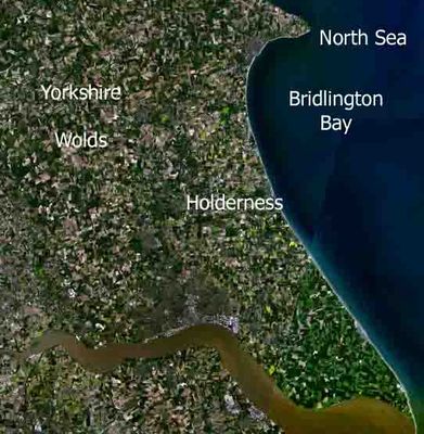
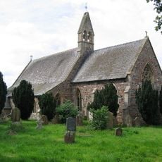
Holderness, Peninsula region in East Riding of Yorkshire, England.

Holderness is a peninsula located between the Humber estuary and the North Sea in East Riding of Yorkshire. The coastline stretches roughly 61 kilometers from Flamborough Head to Spurn Point and is defined by clay cliffs.

Since Roman times, multiple settlements along this coast have disappeared beneath the North Sea due to continuous erosion of the clay cliffs. The landscape has been shaped by these geological forces acting over millennia.

In the 19th century, agricultural development transformed this region from marshland into one of England's most productive farming areas. Today, fields and farmhouses shape the landscape where water and wetland once dominated.

The shoreline experiences continuous erosion, requiring defensive structures at various points, particularly near the towns of Hornsea and Withernsea. Visitors should be aware that access to some coastal sections may be restricted and safety precautions are important.

Beneath the clay layer near Hornsea lie salt cavities used as underground storage facilities for industrial materials. A gas terminal at Easington processes North Sea resources and reveals the modern economic importance of the region.

The community of curious travelers

AroundUs brings together thousands of curated places, local tips, and hidden gems, enriched daily by 60,000 contributors worldwide.

Start exploring
GPS coordinates
53.84000,-0.18000
Latest update
December 20, 2025 14:16
Around this place
Burton Constable Hall
United Kingdom

Burton Constable Hall

3.1 km
Burton Constable Hall & Grounds
United Kingdom

Burton Constable Hall & Grounds

3.1 km
United Kingdom

Church of the Most Holy Sacrement

1.4 km
Church of St Alban
United Kingdom

Church of St Alban

896 m
Bridge Over The Lake Approxiately 35 Metres To South-West Of Burton Constable Hall
United Kingdom

Bridge Over The Lake Approxiately 35 Metres To South-West Of Burton Constable Hall

3.9 km
United Kingdom

Head Gardener's Cottage Approximately 54 Metres To West Of Burton Constable Hall

3.4 km
United Kingdom

Fairfield Farmhouse

4.2 km
Tower House
United Kingdom

Tower House

3.6 km
United Kingdom

Langthorpe Hall

3.5 km
United Kingdom

Wood Hall Farmhouse

4.2 km
Great Hatfield Cross
United Kingdom

Great Hatfield Cross

3.3 km
United Kingdom

Low Fosham Farmhouse And Flanking Wings

1.4 km
United Kingdom

Bewick Hall

3.4 km
United Kingdom

Bewick Hall moated site

3.4 km
United Kingdom

Burton Constable medieval settlement and field system, north of Burton Constable Hall

2.9 km
United Kingdom

Wood House

2 km
United Kingdom

Heavy Anti-aircraft gunsite at Old Ellerby, 600m south of Ellerby Grange

3.8 km
United Kingdom

The Old School House

1.4 km
United Kingdom

Gardeners Cottage Approximately 25 Metres To South-East Of Burton Constable Hall

3.2 km
United Kingdom

Carr Farmhouse

4.1 km
United Kingdom

Mount Pleasant Farmhouse

2 km
United Kingdom

Aldbrough Castle

4.1 km
United Kingdom

Ha-Ha Approximately 20 Metres To South Of Burton Constable Hall

3.2 km
United Kingdom

Garden Cottage Approximately 50 Metres To West Of Burton Constable Hall

3.3 km
United Kingdom

Great Hatfield War Memorial

3.5 km
United Kingdom

The Orangery Approximately 10 Metres to South-west of Burton Constable Hall

3.2 km
United Kingdom

Stables and Carriage House Approximately 20 Metres to South-east of Burton Constable Hall

3.2 km
United Kingdom

The Menagerie Approximately 45 Metres to West of Burton Constable Hall

3.4 km
Show the full map
Reviews
Share your experience

No review yet

Discussions
Start a discussion...

No discussion yet

« Holderness - Peninsula region in East Riding of Yorkshire, England » is provided by Around Us (aroundus.com). Images and texts are derived from Wikimedia project under a Creative Commons license. You are allowed to copy, distribute, and modify copies of this page, under the conditions set by the license, as long as this note is clearly visible.

Discover hidden gems everywhere you go!

From secret cafés to breathtaking viewpoints, skip the crowded tourist spots and find places that match your style. Our app makes it easy with voice search, smart filtering, route optimization, and insider tips from travelers worldwide. Download now for the complete mobile experience.

Around Us App Screenshot

A unique approach to discovering new places

Le Figaro

All the places worth exploring

France Info

A tailor-made excursion in just a few clicks

20 Minutes

Around Us
Travel Guide & Maps
Download

Send to your phone

QR Code
1

Open the camera app on your mobile.

2

Point at the QR code with your camera. A notification will appear.

3

Tap the notification to open the link.