Enable Location

We need your location to show you interesting places around you

Discover nearby places

Find interesting locations and hidden gems around you

Precise directions

Get accurate directions and distances to places

Your location is never shared with other users. It's only used when you tap the location button.

Williams County

Log in to your account

Start exploring — it's free

Trusted by 61,865 travelers worldwide

Continue with Google
Continue with Apple
or

We will send you a code to connect

By continuing, you accept our Terms and Conditions and our Privacy Policy

Check your inbox

We've sent a pincode in your inbox. Please enter the code below.

Williams County, Administrative county in northwestern Ohio, United States.

Description

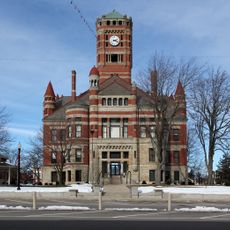
Williams County is an administrative county in northwestern Ohio that includes several small towns and communities across a predominantly agricultural landscape. Bryan serves as the county seat where the main government buildings and services are located.

History

It was established in 1820 when Ohio created several new administrative counties to organize its growing territory. Since its founding, the region has developed primarily as an agricultural area.

Culture

The county operates through a network of elected officials, including commissioners, sheriffs, and coroners who maintain local governmental traditions.

Practical

Visitors will find the main government services and information in Bryan, where the administrative center is located. The rural nature of the area means you will need time and a vehicle to travel between communities.

Did you know?

The county maintains specific jurisdictional authority over law enforcement, with the sheriff holding the highest position within local law enforcement structure.

Location
Inception
February 12, 1820
Capital city
Bryan
Shares border with
Hillsdale County, Defiance County, Fulton County, Henry County, DeKalb County, Steuben County
GPS coordinates
41.56000,-84.58000
Latest update
December 7, 2025 19:29

AroundUs brings together thousands of curated places, local tips, and hidden gems, enriched daily by 60,000 contributors worldwide. Discover all places nearby (Ohio).

Around this place
Fort Defiance
United States of America

Fort Defiance

35.6 km
Goll Woods State Nature Preserve
United States of America

Goll Woods State Nature Preserve

18.2 km
Harrison Lake State Park
United States of America

Harrison Lake State Park

19.5 km
Powers Church
United States of America

Powers Church

23 km
Defiance County Courthouse
United States of America

Defiance County Courthouse

35.5 km
Gamaliel Thompson House
United States of America

Gamaliel Thompson House

37.5 km
Steuben County Courthouse
United States of America

Steuben County Courthouse

35.9 km
Defiance Public Library
United States of America

Defiance Public Library

35.5 km
Goll Homestead
United States of America

Goll Homestead

18 km
Enos Michael House
United States of America

Enos Michael House

34.9 km
Williams County Courthouse
United States of America

Williams County Courthouse

9.7 km
Dey Road Bridge
United States of America

Dey Road Bridge

34.1 km
Dr. Leonard Hall House
United States of America

Dr. Leonard Hall House

37.7 km
Murray D. Van Wagoner Memorial Bridge
United States of America

Murray D. Van Wagoner Memorial Bridge

35 km
St. Paul's Episcopal Church
United States of America

St. Paul's Episcopal Church

33.5 km
Angola Commercial Historic District
United States of America

Angola Commercial Historic District

36 km
Trunk Line Bridge No. 237
United States of America

Trunk Line Bridge No. 237

23.4 km
Heman R. Goodrich House
United States of America

Heman R. Goodrich House

37.3 km
Kunkle Log House
United States of America

Kunkle Log House

11.7 km
William L. Lords House
United States of America

William L. Lords House

31.2 km
George S. Clement House
United States of America

George S. Clement House

36.4 km
Downtown Butler Historic District
United States of America

Downtown Butler Historic District

28.3 km
Jones-Read-Touvelle House
United States of America

Jones-Read-Touvelle House

36.8 km
Nettle Lake Mound Group
United States of America

Nettle Lake Mound Group

19 km
Riverside Chapel
United States of America

Riverside Chapel

36.1 km
Strand Theatre
United States of America

Strand Theatre

35.9 km
Lockport Covered Bridge
United States of America

Lockport Covered Bridge

15.8 km
Spemica Lawba-Johnny Logan
United States of America

Spemica Lawba-Johnny Logan

35.6 km
Show the full map
« Williams County - Administrative county in northwestern Ohio, United States » is provided by Around Us (aroundus.com). Images and texts are derived from Wikimedia project under a Creative Commons license. You are allowed to copy, distribute, and modify copies of this page, under the conditions set by the license, as long as this note is clearly visible.

Discover hidden gems everywhere you go!

From secret cafés to breathtaking viewpoints, skip the crowded tourist spots and find places that match your style. Our app makes it easy with voice search, smart filtering, route optimization, and insider tips from travelers worldwide. Download now for the complete mobile experience.

Around Us App Screenshot

A unique approach to discovering new places

Le Figaro

All the places worth exploring

France Info

A tailor-made excursion in just a few clicks

20 Minutes

Around Us
Travel Guide & Maps
Download

Send to your phone

QR Code
1

Open the camera app on your mobile.

2

Point at the QR code with your camera. A notification will appear.

3

Tap the notification to open the link.