Monroe County

Log in to your account

AroundUs is a community-driven map of interesting places, built by curious explorers like you. It grows with every review, story, and photo you share.
Connect to save your favorite spots, contribute locations, and create personalized routes.
By continuing, you accept our Terms and Conditions and our Privacy Policy
Add to collection
Map
Suggest a change
Share

Monroe County, County administrative division in Kentucky, US.
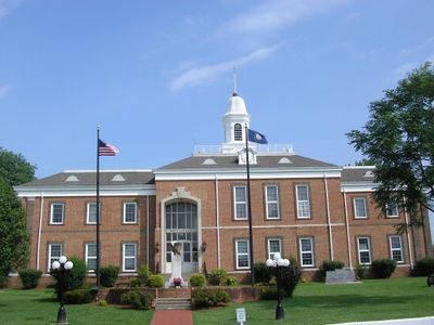
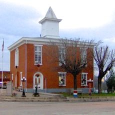
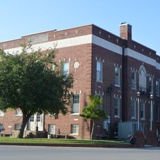
Located in the Eastern Pennyroyal Plateau region of Kentucky, Monroe County spans 332 square miles of land with hills, valleys, and agricultural landscapes.

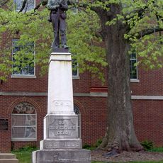
The county was established in 1820 and named after President James Monroe, with Tompkinsville designated as the county seat.

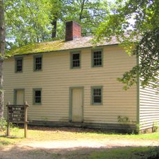
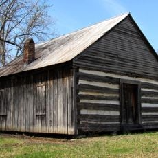
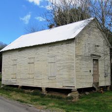
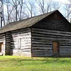
The Old Mulkey Meetinghouse State Historic Site preserves Kentucky's oldest log meetinghouse, built in 1804, with a cemetery containing Revolutionary War veterans.

Kentucky Routes 63 and 100 connect Monroe County to neighboring cities, with public services and amenities available in the county seat of Tompkinsville.

Monroe County remained a dry county until November 2023, when residents voted to permit alcohol sales after more than two centuries of prohibition.

Location: Kentucky

Inception: January 19, 1820

Capital city: Tompkinsville

Website: http://www.monroecounty.ky.gov

Shares border with: Clay County, Barren County, Metcalfe County, Cumberland County, Macon County, Allen County

Website: http://monroecounty.ky.gov

GPS coordinates: 36.71000,-85.72000

Latest update: March 6, 2025 15:12

Around this place
Show the full map
Standing Stone State Park
United States of America

Standing Stone State Park

38.1 km
Barren River Lake
United States of America

Barren River Lake

41.5 km
Barren River Lake State Resort Park
United States of America

Barren River Lake State Resort Park

35.6 km
Donoho Hotel
United States of America

Donoho Hotel

22.8 km
Old Mulkey Meetinghouse State Historic Site
United States of America

Old Mulkey Meetinghouse State Historic Site

3.8 km
Confederate Monument in Glasgow
United States of America

Confederate Monument in Glasgow

36.1 km
Metcalfe County Jail
United States of America

Metcalfe County Jail

31.6 km
Sulphur Well Historic District
United States of America

Sulphur Well Historic District

44.2 km
Mount Vernon AME Church
United States of America

Mount Vernon AME Church

8.1 km
Long Creek School
United States of America

Long Creek School

37.5 km
Marrowbone Historic District
United States of America

Marrowbone Historic District

23.4 km
Bell House
United States of America

Bell House

36.9 km
Stockton-Ray House
United States of America

Stockton-Ray House

32.2 km
Clay County Courthouse
United States of America

Clay County Courthouse

26.1 km
James Baker House
United States of America

James Baker House

34.8 km
Metcalfe County Kentucky Courthouse
United States of America

Metcalfe County Kentucky Courthouse

31.5 km
Scottsville Downtown Commercial Historic District
United States of America

Scottsville Downtown Commercial Historic District

42.3 km
Belview School
United States of America

Belview School

26.3 km
Coe House
United States of America

Coe House

33 km
Bybee House
United States of America

Bybee House

40.1 km
The Tabernacle
United States of America

The Tabernacle

41.5 km
Dr. Pellie G. Graves House
United States of America

Dr. Pellie G. Graves House

41.9 km
Old Mulkey Meetinghouse
United States of America

Old Mulkey Meetinghouse

3.8 km
Macon County Fairgrounds
United States of America

Macon County Fairgrounds

37.8 km
Plaza Theatre
United States of America

Plaza Theatre

36.1 km
Lafayette Theatre
United States of America

Lafayette Theatre

34.6 km
Standing Stone Rustic Park Historic District
United States of America

Standing Stone Rustic Park Historic District

37.9 km
Cumberland County Courthouse
United States of America

Cumberland County Courthouse

32.4 km
Show the full map

Reviews

Visited this place? Tap the stars to rate it and share your experience / photos with the community! Try now! You can cancel it anytime.

« Monroe County - County administrative division in Kentucky, US. » is provided by Around Us (aroundus.com). Images and texts are derived from Wikimedia project under a Creative Commons license. You are allowed to copy, distribute, and modify copies of this page, under the conditions set by the license, as long as this note is clearly visible.

Discover hidden gems everywhere you go!

From secret cafés to breathtaking viewpoints, skip the crowded tourist spots and find places that match your style. Our app makes it easy with voice search, smart filtering, route optimization, and insider tips from travelers worldwide. Download now for the complete mobile experience.

Around Us App Screenshot

A unique approach to discovering new places

Le Figaro

All the places worth exploring

France Info

A tailor-made excursion in just a few clicks

20 Minutes