Chest opened
+${chestReward.xp} XP
Explorer
NOUVEAU ×${chestReward.collectible.quantity}
tapez pour fermer
Chest locked

Open chests in the app

Around Us is built for your phone — chests unlock when you walk, explore and capture nearby places.

Enable Location

We need your location to show you interesting places around you

Discover nearby places

Find interesting locations and hidden gems around you

Precise directions

Get accurate directions and distances to places

Your location is never shared with other users. It's only used when you tap the location button.

Berkeley Heights

Log in to your account

Start exploring — it's free

Trusted by 72,880 travelers worldwide

Continue with Google
Continue with Apple
or

We will send you a code to connect

By continuing, you accept our Terms and Conditions and our Privacy Policy

Check your inbox

We've sent a pincode in your inbox. Please enter the code below.

Discussion Reviews 1 Photos
34.8k Popularity

Berkeley Heights, Township in Union County, New Jersey, US.

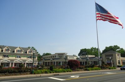
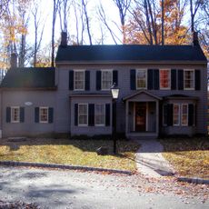
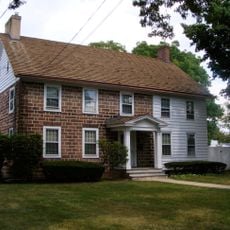
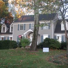
Berkeley Heights is a township in Union County in northern New Jersey, situated on elevated terrain at about 131 meters above sea level. The area combines residential neighborhoods with open spaces and a quieter character than surrounding urban centers.

The area was established in 1809 as New Providence Township and renamed Berkeley Heights in 1951, marking a shift in the community's identity. This change reflected the township's evolution from its agricultural origins.

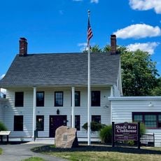
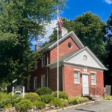
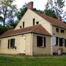
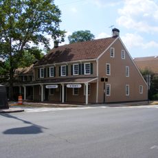
The Littell-Lord Farmhouse Museum from 1760 displays collections that reflect the region's farming heritage and offers visitors a glimpse into how earlier residents lived. Walking through its rooms reveals the daily rhythms and agricultural practices of the past.

The township has several roads and pathways that are accessible by foot or car for exploring the area at a leisurely pace. Plan time to visit the museum and walk the local trails if interested in the region's history.

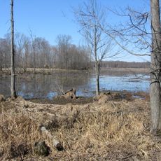
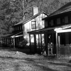
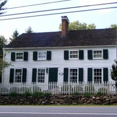
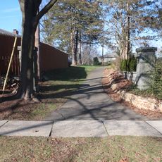
Feltville was a textile mill village founded in 1845 that was later abandoned and then preserved as an open-air site. Today visitors can walk through original structures and paths that tell the story of early industrial and residential life.

The community of curious travelers

AroundUs brings together thousands of curated places, local tips, and hidden gems, enriched daily by 60,000 contributors worldwide.

Start exploring
Location
Elevation above the sea
131 m
Shares border with
Scotch Plains, Summit, Watchung, Warren Township, Long Hill Township, Chatham Township, Mountainside, New Providence
GPS coordinates
40.67750,-74.42972
Latest update
December 19, 2025 22:29
Around this place
Great Swamp National Wildlife Refuge
United States of America

Great Swamp National Wildlife Refuge

4.6 km
Watchung Reservation
United States of America

Watchung Reservation

4.9 km
Feltville Historic District
United States of America

Feltville Historic District

3.6 km
United States of America

Bowcraft Amusement Park

3.8 km
Shady Rest Golf and Country Club
United States of America

Shady Rest Golf and Country Club

5.4 km
Mount Vernon School
United States of America

Mount Vernon School

5.4 km
Deacon Andrew Hetfield House
United States of America

Deacon Andrew Hetfield House

6.1 km
Old Baptist Parsonage
United States of America

Old Baptist Parsonage

3.8 km
Nathaniel Smith House
United States of America

Nathaniel Smith House

1.7 km
Firehouse No. 4
United States of America

Firehouse No. 4

5.9 km
Littel-Lord Farmstead
United States of America

Littel-Lord Farmstead

1.1 km
118 Prospect St, Summit, NJ
United States of America

118 Prospect St, Summit, NJ

6.3 km
Snyder Avenue Spraypark
United States of America

Snyder Avenue Spraypark

654 m
29 Druid Hill Road, Smmit, NJ
United States of America

29 Druid Hill Road, Smmit, NJ

6 km
34 Laurel Avenue, Summi, NJ
United States of America

34 Laurel Avenue, Summi, NJ

6.6 km
United States of America

Berkeley Heights observatory

1.4 km
41 Sweetbriar Road, Summit, NJ
United States of America

41 Sweetbriar Road, Summit, NJ

5.4 km
United States of America

Footpath from Glenside to Oakridge

6.4 km
Fanwood Park Historic District
United States of America

Fanwood Park Historic District

5.1 km
Footpath between Springfield and Nassau
United States of America

Footpath between Springfield and Nassau

6.3 km
9 High Street, Summit, NJ
United States of America

9 High Street, Summit, NJ

6.4 km
United States of America

Lake Surprise

4.4 km
Stage House Inn
United States of America

Stage House Inn

3.9 km
United States of America

Scotch Hills Golf Course

5.1 km
Scotch Plains School
United States of America

Scotch Plains School

4.2 km
United States of America

Color Field Sculpture

3.4 km
United States of America

Virgin Mary Statue

3.4 km
United States of America

Scenic viewpoint

3 km
Show the full map
Reviews
Share your experience

No review yet

Discussions
Start a discussion...

No discussion yet

« Berkeley Heights - Township in Union County, New Jersey, US » is provided by Around Us (aroundus.com). Images and texts are derived from Wikimedia project under a Creative Commons license. You are allowed to copy, distribute, and modify copies of this page, under the conditions set by the license, as long as this note is clearly visible.

Discover hidden gems everywhere you go!

From secret cafés to breathtaking viewpoints, skip the crowded tourist spots and find places that match your style. Our app makes it easy with voice search, smart filtering, route optimization, and insider tips from travelers worldwide. Download now for the complete mobile experience.

Around Us App Screenshot

A unique approach to discovering new places

Le Figaro

All the places worth exploring

France Info

A tailor-made excursion in just a few clicks

20 Minutes

Around Us
Travel Guide & Maps
Download

Send to your phone

QR Code
1

Open the camera app on your mobile.

2

Point at the QR code with your camera. A notification will appear.

3

Tap the notification to open the link.