Enable Location

We need your location to show you interesting places around you

Discover nearby places

Find interesting locations and hidden gems around you

Precise directions

Get accurate directions and distances to places

Your location is never shared with other users. It's only used when you tap the location button.

Warrensburg

Log in to your account

Start exploring — it's free

Trusted by 68,293 travelers worldwide

Continue with Google
Continue with Apple
or

We will send you a code to connect

By continuing, you accept our Terms and Conditions and our Privacy Policy

Check your inbox

We've sent a pincode in your inbox. Please enter the code below.

Discussion Reviews 1 Photos
36.5k Popularity

Warrensburg, County seat in Johnson County, Missouri.

Warrensburg is a city in Johnson County, located in central Missouri near Whiteman Air Force Base. The city sits where major routes intersect, making it a junction point for regional travel and commerce.

John and Martin Warren founded the settlement in 1835, establishing what would grow into the city. A post office opened two years later, marking its connection to the broader region.

The University of Central Missouri shapes daily life with its students and faculty moving through town, making it a center for learning and community exchange. The institution has become woven into how residents think about their city.

The city connects to Kansas City and surrounding areas through US Route 50 and Missouri Route 13, the main roads running through. Getting around on foot or by car is straightforward once you understand the basic layout.

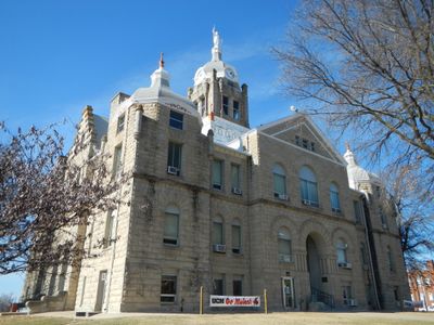
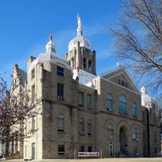
The Johnson County Courthouse features a statue of Old Drum, honoring a dog whose legal case produced a famous phrase about human-animal bonds. The trial became known far beyond the town and left its mark on American language.

The community of curious travelers

AroundUs brings together thousands of curated places, local tips, and hidden gems, enriched daily by 60,000 contributors worldwide.

Start exploring
Location
Inception
1855
Elevation above the sea
263 m
GPS coordinates
38.76310,-93.73500
Latest update
December 17, 2025 10:50
Around this place
Knob Noster State Park
United States of America

Knob Noster State Park

11.8 km
Johnson County Courthouse
United States of America

Johnson County Courthouse

527 m
Howard School
United States of America

Howard School

828 m
United States of America

Masonic Temple

476 m
Jones Brothers Mule Barn
United States of America

Jones Brothers Mule Barn

268 m
Johnson County Courthouse
United States of America

Johnson County Courthouse

1.4 km
Warren Street Methodist Episcopal Church
United States of America

Warren Street Methodist Episcopal Church

854 m
Grover Street Victorian Historic District
United States of America

Grover Street Victorian Historic District

232 m
United States of America

John A. Adams Farmstead Historic District

9.6 km
United States of America

Lewis and Sophie Griebel House

953 m
United States of America

Herbert A. and Bettie E. Cress House

886 m
Montserrat Recreational Demonstration Area Bridge
United States of America

Montserrat Recreational Demonstration Area Bridge

13.8 km
Montserrat Recreational Demonstration Area Rock Bath House
United States of America

Montserrat Recreational Demonstration Area Rock Bath House

13.2 km
United States of America

Moonglow observatory

7.9 km
United States of America

Montserrat Recreation Demonstration Area Entrance Portal

14.6 km
United States of America

Rolling Hills Observatory

9.6 km
United States of America

Lake Pajastka

13.2 km
United States of America

Lions Lake

2.3 km
United States of America

Camp Shawnee Historic District

10.2 km
United States of America

Star Theater

531 m
United States of America

Royal Oaks Golf Course

13.2 km
United States of America

Keth Memorial Golf Course

2.6 km
United States of America

Hidden Pines Country Club

2.4 km

Highlander Theater

729 m
United States of America

Mo the Mule

843 m
United States of America

Northrop B-2 Spirit

14.5 km
United States of America

Statue, Work of art

517 m
United States of America

Boeing SB-29 Superfortress

14.1 km
Show the full map
Reviews
Share your experience

No review yet

Discussions
Start a discussion...

No discussion yet

« Warrensburg - County seat in Johnson County, Missouri » is provided by Around Us (aroundus.com). Images and texts are derived from Wikimedia project under a Creative Commons license. You are allowed to copy, distribute, and modify copies of this page, under the conditions set by the license, as long as this note is clearly visible.

Discover hidden gems everywhere you go!

From secret cafés to breathtaking viewpoints, skip the crowded tourist spots and find places that match your style. Our app makes it easy with voice search, smart filtering, route optimization, and insider tips from travelers worldwide. Download now for the complete mobile experience.

Around Us App Screenshot

A unique approach to discovering new places

Le Figaro

All the places worth exploring

France Info

A tailor-made excursion in just a few clicks

20 Minutes

Around Us
Travel Guide & Maps
Download

Send to your phone

QR Code
1

Open the camera app on your mobile.

2

Point at the QR code with your camera. A notification will appear.

3

Tap the notification to open the link.