Enable Location

We need your location to show you interesting places around you

Discover nearby places

Find interesting locations and hidden gems around you

Precise directions

Get accurate directions and distances to places

Your location is never shared with other users. It's only used when you tap the location button.

Claiborne Pell Newport Bridge

Log in to your account

Start exploring — it's free

Trusted by 62,558 travelers worldwide

Continue with Google
Continue with Apple
or

We will send you a code to connect

By continuing, you accept our Terms and Conditions and our Privacy Policy

Check your inbox

We've sent a pincode in your inbox. Please enter the code below.

Claiborne Pell Newport Bridge

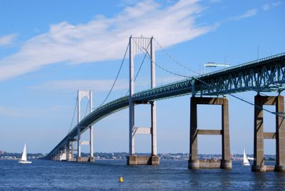
Claiborne Pell Newport Bridge, Suspension bridge in Newport, United States

The Claiborne Pell Newport Bridge is a suspension bridge that stretches 3,428 meters (11,247 feet) across the East Passage of Narragansett Bay, connecting Newport with Jamestown on Conanicut Island. The main towers rise 120 meters (394 feet) above the water and support four traffic lanes that carry thousands of vehicles daily over the bay.

Work on the bridge started in 1966 and required three years of intensive construction involving 200 workers, tugboats, and barges transporting building materials across the water. Completion in 1969 shortened the journey between Newport and Jamestown significantly and eliminated dependence on ferries.

The bridge carries the name of Senator Claiborne Pell since 1992, though many Rhode Island residents still call it Newport Bridge. The naming honors a politician who worked for the region, while the old designation emphasizes its geographic connection.

Vehicles without an E-ZPass transponder pay a toll of 6 dollars when crossing to fund ongoing maintenance and operations. The four lanes on Route 138 allow steady traffic flow, and pedestrians or cyclists are not permitted to use the bridge.

The main span measures 490 meters (1,608 feet) and makes this structure the longest suspension bridge in the New England region. This section between the two main towers allows large ships to pass freely beneath the roadway.

The community of curious travelers

AroundUs brings together thousands of curated places, local tips, and hidden gems, enriched daily by 60,000 contributors worldwide.

Start exploring
Location
Inception
June 28, 1969
Official opening
June 28, 1969
Height
120 m
Length
3,428 m
Longest Span
490 m
GPS coordinates
41.50306,-71.34028
Latest update
December 20, 2025 00:39
Around this place
Naval War College
United States of America

Naval War College

1 km
Fort Adams
United States of America

Fort Adams

3.1 km
Fort Wetherill
United States of America

Fort Wetherill

3.2 km
Common Burying Ground and Island Cemetery
United States of America

Common Burying Ground and Island Cemetery

2.2 km
Clingstone
United States of America

Clingstone

2.6 km
Hunter House
United States of America

Hunter House

1.9 km
Rose Island Light
United States of America

Rose Island Light

867 m
Malbone Castle by James Hess Leach
United States of America

Malbone Castle by James Hess Leach

2.5 km
Fort Getty
United States of America

Fort Getty

5.1 km
Naval War College Museum
United States of America

Naval War College Museum

1 km
Great Friends Meeting House
United States of America

Great Friends Meeting House

2.6 km
Horsehead-Marbella
United States of America

Horsehead-Marbella

4.2 km
Newport Harbor Light
United States of America

Newport Harbor Light

1.5 km
Oliver Perry Monument
United States of America

Oliver Perry Monument

2.6 km
Fort Wetherill State Park
United States of America

Fort Wetherill State Park

3.3 km
Fort Hamilton Historic District
United States of America

Fort Hamilton Historic District

748 m
Museum of Newport History
United States of America

Museum of Newport History

2.5 km
Dutch Island Light
United States of America

Dutch Island Light

5.4 km
Artillery Park
United States of America

Artillery Park

3 km
Watson Farm
United States of America

Watson Farm

3.9 km
Luce Hall
United States of America

Luce Hall

1 km
Old Colony and Newport Scenic Railway
United States of America

Old Colony and Newport Scenic Railway

2.2 km
Windmill Hill Historic District
United States of America

Windmill Hill Historic District

3.9 km
William King Covell III House
United States of America

William King Covell III House

1.8 km
President's House
United States of America

President's House

1.2 km
Shoreby Hill Historic District
United States of America

Shoreby Hill Historic District

2.4 km
Taylor-Chase-Smythe House
United States of America

Taylor-Chase-Smythe House

3 km
Mackeral Cove Beach
United States of America

Mackeral Cove Beach

3.9 km
Show the full map
« Claiborne Pell Newport Bridge - Suspension bridge in Newport, United States » is provided by Around Us (aroundus.com). Images and texts are derived from Wikimedia project under a Creative Commons license. You are allowed to copy, distribute, and modify copies of this page, under the conditions set by the license, as long as this note is clearly visible.

Discover hidden gems everywhere you go!

From secret cafés to breathtaking viewpoints, skip the crowded tourist spots and find places that match your style. Our app makes it easy with voice search, smart filtering, route optimization, and insider tips from travelers worldwide. Download now for the complete mobile experience.

Around Us App Screenshot

A unique approach to discovering new places

Le Figaro

All the places worth exploring

France Info

A tailor-made excursion in just a few clicks

20 Minutes

Around Us
Travel Guide & Maps
Download

Send to your phone

QR Code
1

Open the camera app on your mobile.

2

Point at the QR code with your camera. A notification will appear.

3

Tap the notification to open the link.