Chest opened
+${chestReward.xp} XP
Explorer
NOUVEAU ×${chestReward.collectible.quantity}
tapez pour fermer
Chest locked

Open chests in the app

Around Us is built for your phone — chests unlock when you walk, explore and capture nearby places.

Enable Location

We need your location to show you interesting places around you

Discover nearby places

Find interesting locations and hidden gems around you

Precise directions

Get accurate directions and distances to places

Your location is never shared with other users. It's only used when you tap the location button.

Callaway Energy Center

Log in to your account

Start exploring — it's free

Trusted by 72,976 travelers worldwide

Continue with Google
Continue with Apple
or

We will send you a code to connect

By continuing, you accept our Terms and Conditions and our Privacy Policy

Check your inbox

We've sent a pincode in your inbox. Please enter the code below.

Callaway Energy Center
Discussion Reviews 1 Photos
22.1k Popularity

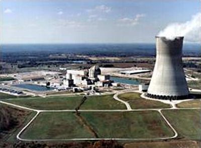
Callaway Energy Center, nuclear power station in Callaway County, Missouri, U.S., operated by Ameren Missouri

Callaway Energy Center is a nuclear power plant in Callaway County, Missouri, in the United States. It runs a single reactor that generates electricity and sends it into the regional power grid.

Construction started in the late 1970s, and the plant began operating in 1984. It has been running continuously since then, supplying power to the surrounding region.

Access to the site is not allowed for security reasons, so there are no public tours of the interior. The cooling towers are visible from roads and public areas near the site.

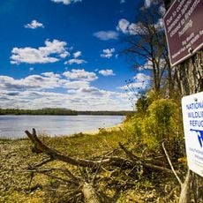
The plant sits on the bank of the Missouri River, which supplies the water used to cool the reactor. Without the river, this location would not have been chosen for a nuclear facility of this type.

The community of curious travelers

AroundUs brings together thousands of curated places, local tips, and hidden gems, enriched daily by 60,000 contributors worldwide.

Start exploring
Location
GPS coordinates
38.76170,-91.78000
Latest update
March 3, 2026 08:22
Around this place
National Churchill Museum
United States of America

National Churchill Museum

18 km
Graham Cave State Park
United States of America

Graham Cave State Park

24 km
Graham Cave
United States of America

Graham Cave

24 km
Big Muddy National Fish and Wildlife Refuge
United States of America

Big Muddy National Fish and Wildlife Refuge

14.3 km
Deutschheim State Historic Site
United States of America

Deutschheim State Historic Site

30.3 km
Missouri State Penitentiary Tours
United States of America

Missouri State Penitentiary Tours

39.2 km
Westminster College Gymnasium
United States of America

Westminster College Gymnasium

18.1 km
Dauphine Hotel
United States of America

Dauphine Hotel

25.9 km
Christopher S. Bond Bridge
United States of America

Christopher S. Bond Bridge

30.2 km
St. Francis Xavier Catholic Church and Rectory
United States of America

St. Francis Xavier Catholic Church and Rectory

37.8 km
Hermann Bridge
United States of America

Hermann Bridge

30.2 km
George Washington Carver School
United States of America

George Washington Carver School

18.2 km
Hermann Historic District
United States of America

Hermann Historic District

30.7 km
Sylvester Marion and Frances Anne Stephens Baker House
United States of America

Sylvester Marion and Frances Anne Stephens Baker House

27.3 km
White Cloud Presbyterian Church and Cemetery
United States of America

White Cloud Presbyterian Church and Cemetery

28.3 km
Brandon-Bell-Collier House
United States of America

Brandon-Bell-Collier House

17.7 km
John Augustus Hockaday House
United States of America

John Augustus Hockaday House

17.1 km
Bonnots Mill Historic District
United States of America

Bonnots Mill Historic District

26 km
High Hill School
United States of America

High Hill School

37 km
M. Fred Bell Speculative Cottage
United States of America

M. Fred Bell Speculative Cottage

17.1 km
Downtown Fulton Historic District
United States of America

Downtown Fulton Historic District

17.6 km
Pitcher Store
United States of America

Pitcher Store

16.2 km
Robnett-Payne House
United States of America

Robnett-Payne House

17.2 km
M. Fred Bell Rental Cottage
United States of America

M. Fred Bell Rental Cottage

17.1 km
Court Street Historic Residential District
United States of America

Court Street Historic Residential District

17.7 km
Farmers Mercantile Co. Building
United States of America

Farmers Mercantile Co. Building

36.7 km
Dr. Enoch T. and Amy Zewicki House
United States of America

Dr. Enoch T. and Amy Zewicki House

31.4 km
Huber's Ferry Farmstead Historic District
United States of America

Huber's Ferry Farmstead Historic District

9.8 km
Show the full map
Reviews
Share your experience

No review yet

Discussions
Start a discussion...

No discussion yet

« Callaway Energy Center - nuclear power station in Callaway County, Missouri, U.S., operated by Ameren Missouri » is provided by Around Us (aroundus.com). Images and texts are derived from Wikimedia project under a Creative Commons license. You are allowed to copy, distribute, and modify copies of this page, under the conditions set by the license, as long as this note is clearly visible.

Discover hidden gems everywhere you go!

From secret cafés to breathtaking viewpoints, skip the crowded tourist spots and find places that match your style. Our app makes it easy with voice search, smart filtering, route optimization, and insider tips from travelers worldwide. Download now for the complete mobile experience.

Around Us App Screenshot

A unique approach to discovering new places

Le Figaro

All the places worth exploring

France Info

A tailor-made excursion in just a few clicks

20 Minutes

Around Us
Travel Guide & Maps
Download

Send to your phone

QR Code
1

Open the camera app on your mobile.

2

Point at the QR code with your camera. A notification will appear.

3

Tap the notification to open the link.