Chest opened
+${chestReward.xp} XP
Explorer
NOUVEAU ×${chestReward.collectible.quantity}
tapez pour fermer
Chest locked

Open chests in the app

Around Us is built for your phone — chests unlock when you walk, explore and capture nearby places.

Enable Location

We need your location to show you interesting places around you

Discover nearby places

Find interesting locations and hidden gems around you

Precise directions

Get accurate directions and distances to places

Your location is never shared with other users. It's only used when you tap the location button.

New Melones Dam

Log in to your account

Start exploring — it's free

Trusted by 72,929 travelers worldwide

Continue with Google
Continue with Apple
or

We will send you a code to connect

By continuing, you accept our Terms and Conditions and our Privacy Policy

Check your inbox

We've sent a pincode in your inbox. Please enter the code below.

Discussion Reviews 1 Photos
10.5k Popularity

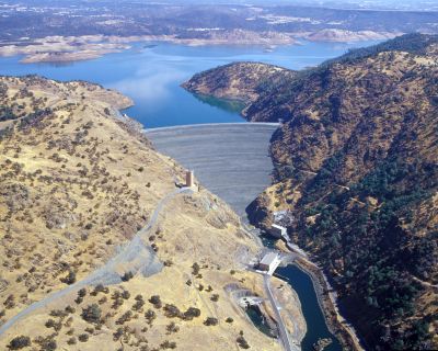
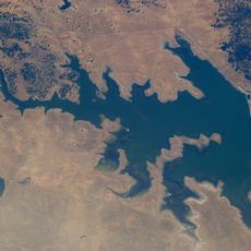
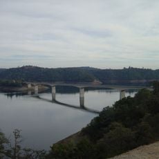
New Melones Dam, Embankment dam and hydroelectric station in Tuolumne County, United States

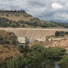
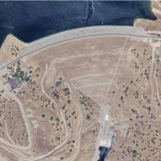
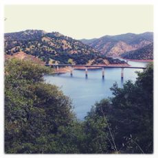
New Melones Dam is a large earthen embankment structure on the Stanislaus River in central California with integrated hydroelectric facilities. The structure holds back a substantial reservoir that supplies water and power to the surrounding region.

Construction began in 1966 as part of a federal water management initiative, with power generation starting in 1979. The project reflected California's mid-century push to develop its water and energy resources.

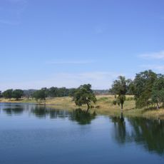
The reservoir has become a gathering place for fishing, boating, and camping that draws people from surrounding communities. The water body defines leisure activities across the region.

A public road runs across the top of the structure, making it easy to view from a vehicle or by stopping at pullouts. Weekday visits tend to be less crowded than weekends, though the site remains accessible year-round.

The project faced a dramatic protest in the late 1970s when an environmental activist chained himself to a canyon boulder to stop the filling of the reservoir. This bold act became an iconic moment in American environmental activism.

The community of curious travelers

AroundUs brings together thousands of curated places, local tips, and hidden gems, enriched daily by 60,000 contributors worldwide.

Start exploring
Location
Inception
1966
Length
475 m
GPS coordinates
37.94720,-120.52800
Latest update
December 10, 2025 15:53
Around this place
New Melones Lake
United States of America

New Melones Lake

5.8 km
Moaning Cavern
United States of America

Moaning Cavern

14.6 km
Railtown 1897 State Historic Park
United States of America

Railtown 1897 State Historic Park

9.7 km
Murphys Hotel
United States of America

Murphys Hotel

21.8 km
Lake Tulloch
United States of America

Lake Tulloch

7.6 km
New Don Pedro Dam
United States of America

New Don Pedro Dam

29.1 km
Mercer Caverns
United States of America

Mercer Caverns

23.2 km
California Caverns
United States of America

California Caverns

28.5 km
Angels Hotel
United States of America

Angels Hotel

13.6 km
Knight's Ferry Bridge
United States of America

Knight's Ferry Bridge

18.5 km
Salt Spring Valley Reservoir
United States of America

Salt Spring Valley Reservoir

21.9 km
Hotel Charlotte
United States of America

Hotel Charlotte

28.9 km
Track Bus No. 19
United States of America

Track Bus No. 19

9.8 km
Altaville Grammar School
United States of America

Altaville Grammar School

15.4 km
Thorn House
United States of America

Thorn House

30.6 km
Calaveras County Courthouse
United States of America

Calaveras County Courthouse

30.8 km
Archie Stevenot Bridge
United States of America

Archie Stevenot Bridge

6.8 km
John J. Snyder House
United States of America

John J. Snyder House

31.1 km
Douglas Flat School
United States of America

Douglas Flat School

20 km
Sam Choy Brick Store
United States of America

Sam Choy Brick Store

13.6 km
Copperopolis Congregational Church
United States of America

Copperopolis Congregational Church

10.4 km
Utica Mansion
United States of America

Utica Mansion

13.8 km
Abraham Schell House
United States of America

Abraham Schell House

19.1 km
Murphys Grammar School
United States of America

Murphys Grammar School

21.9 km
Groveland Hotel
United States of America

Groveland Hotel

28.9 km
Calaveras County Bank
United States of America

Calaveras County Bank

13.7 km
Gamble Building and Miner's Bean Kettle
United States of America

Gamble Building and Miner's Bean Kettle

27.5 km
Jacksonville Road Bridge
United States of America

Jacksonville Road Bridge

20.2 km
Show the full map
Reviews
Share your experience

No review yet

Discussions
Start a discussion...

No discussion yet

« New Melones Dam - Embankment dam and hydroelectric station in Tuolumne County, United States » is provided by Around Us (aroundus.com). Images and texts are derived from Wikimedia project under a Creative Commons license. You are allowed to copy, distribute, and modify copies of this page, under the conditions set by the license, as long as this note is clearly visible.

Discover hidden gems everywhere you go!

From secret cafés to breathtaking viewpoints, skip the crowded tourist spots and find places that match your style. Our app makes it easy with voice search, smart filtering, route optimization, and insider tips from travelers worldwide. Download now for the complete mobile experience.

Around Us App Screenshot

A unique approach to discovering new places

Le Figaro

All the places worth exploring

France Info

A tailor-made excursion in just a few clicks

20 Minutes

Around Us
Travel Guide & Maps
Download

Send to your phone

QR Code
1

Open the camera app on your mobile.

2

Point at the QR code with your camera. A notification will appear.

3

Tap the notification to open the link.