New Don Pedro Dam

Log in to your account

AroundUs is a community-driven map of interesting places, built by curious explorers like you. It grows with every review, story, and photo you share.
Connect to save your favorite spots, contribute locations, and create personalized routes.
By continuing, you accept our Terms and Conditions and our Privacy Policy
Add to collection
Map
Suggest a change
Share

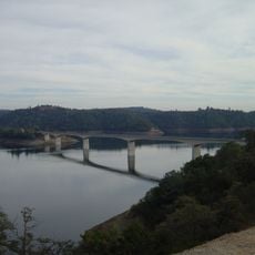
New Don Pedro Dam, Earth and rockfill dam in Tuolumne County, United States

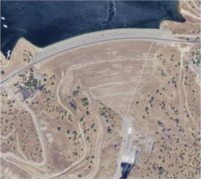
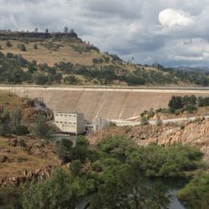
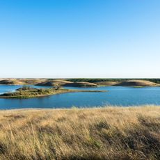
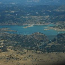
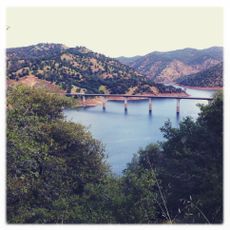
New Don Pedro Dam is an earth and rockfill dam across the Tuolumne River in California's Sierra Nevada foothills. The structure spans 579 meters and creates a large reservoir that serves both water storage and electricity generation needs.

Construction began in 1967 to replace an earlier dam built in 1923, representing a major upgrade in water management for the region. The new structure expanded the capacity to serve growing agricultural and energy needs.

The dam received its name from Pierre Sainsevain, a French prospector known as Don Pedro, who established a mining settlement near the original dam location.

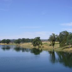
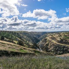
The site is accessible from nearby towns and offers overlooks of the reservoir and surrounding landscape. Spring and fall provide the most pleasant visiting conditions, with moderate temperatures and good visibility across the water.

Beneath the current reservoir surface lie the submerged remains of the original 1923 dam, which held the record as the world's highest dam when it was completed. This hidden history reflects how engineering and water management evolved over the generations.
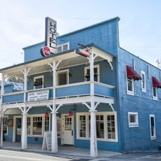
Location: Tuolumne County

Inception: 1967

Length: 579 m

GPS coordinates: 37.69940,-120.42100

Latest update: December 10, 2025 15:49

Photos
Around this place
New Melones Lake
United States of America

New Melones Lake

34.5 km
Railtown 1897 State Historic Park
United States of America

Railtown 1897 State Historic Park

28 km
Lake Tulloch
United States of America

Lake Tulloch

26.3 km
Lake McClure
United States of America

Lake McClure

13.7 km
Turlock Lake State Recreation Area
United States of America

Turlock Lake State Recreation Area

16.3 km
New Exchequer Dam
United States of America

New Exchequer Dam

18.4 km
Knight's Ferry Bridge
United States of America

Knight's Ferry Bridge

25.2 km
Gold Dredge
United States of America

Gold Dredge

8.8 km
Hotel Charlotte (Groveland, California)
United States of America

Hotel Charlotte (Groveland, California)

23 km
Track Bus No. 19
United States of America

Track Bus No. 19

27.9 km
Archie Stevenot Bridge
United States of America

Archie Stevenot Bridge

34.6 km
Castle Air Museum
United States of America

Castle Air Museum

39.7 km
Odd Fellows Hall
United States of America

Odd Fellows Hall

5.4 km
Copperopolis Congregational Church
United States of America

Copperopolis Congregational Church

36.6 km
Abraham Schell House
United States of America

Abraham Schell House

25.9 km
Groveland Hotel
United States of America

Groveland Hotel

23 km
Hornitos Masonic Hall No. 98
United States of America

Hornitos Masonic Hall No. 98

27.4 km
Old Adobe Barn
United States of America

Old Adobe Barn

5.2 km
Gamble Building and Miner's Bean Kettle
United States of America

Gamble Building and Miner's Bean Kettle

20 km
Bower Cave
United States of America

Bower Cave

34.3 km
Jacksonville Road Bridge
United States of America

Jacksonville Road Bridge

16.7 km
Wallace Dining Center
United States of America

Wallace Dining Center

37.3 km
La Grange Dam
United States of America

La Grange Dam

3.7 km
Old La Grange Schoolhouse
United States of America

Old La Grange Schoolhouse

5.4 km
Coulterville Main Street Historic District
United States of America

Coulterville Main Street Historic District

19.7 km
Groveland Ranger Station
United States of America

Groveland Ranger Station

31.6 km
Rim of the World Vista
United States of America

Rim of the World Vista

36.3 km
South Fork Tuolumne River Bridge
United States of America

South Fork Tuolumne River Bridge

38.4 km
Show the full map
Reviews

Visited this place? Tap the stars to rate it and share your experience / photos with the community! Try now! You can cancel it anytime.

« New Don Pedro Dam - Earth and rockfill dam in Tuolumne County, United States » is provided by Around Us (aroundus.com). Images and texts are derived from Wikimedia project under a Creative Commons license. You are allowed to copy, distribute, and modify copies of this page, under the conditions set by the license, as long as this note is clearly visible.

Discover hidden gems everywhere you go!

From secret cafés to breathtaking viewpoints, skip the crowded tourist spots and find places that match your style. Our app makes it easy with voice search, smart filtering, route optimization, and insider tips from travelers worldwide. Download now for the complete mobile experience.

Around Us App Screenshot

A unique approach to discovering new places

Le Figaro

All the places worth exploring

France Info

A tailor-made excursion in just a few clicks

20 Minutes