Enable Location

We need your location to show you interesting places around you

Discover nearby places

Find interesting locations and hidden gems around you

Precise directions

Get accurate directions and distances to places

Your location is never shared with other users. It's only used when you tap the location button.

Gold Dredge

Log in to your account

Start exploring — it's free

Trusted by 61,355 travelers worldwide

Continue with Google
Continue with Apple
or

We will send you a code to connect

By continuing, you accept our Terms and Conditions and our Privacy Policy

Check your inbox

We've sent a pincode in your inbox. Please enter the code below.

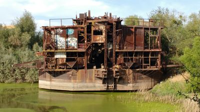
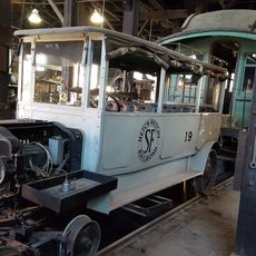
Gold Dredge, Gold dredge in La Grange, California.

Description

The Walter Johnson No. 52 is a bucket line dredge that operated in the region with 120 buckets designed to extract gold from deep below the surface. The machine covers an area larger than a football field and weighs around 2,500 tons in total.

History

The dredge started operations at Patricksville in 1938 and ran until 1951, when falling gold prices made continued extraction no longer profitable. Its closure represented the end of large-scale gold mining operations in this area.

Culture

The site received recognition on the National Register of Historic Places in 1971, preserving the memory of California's industrial mining operations.

Practical

The site sits on private property with restricted access, so visitors can view it from outside or need permission from the owner to enter. It is located about two miles south of California Highway 132 near County Route J59.

Did you know?

Each of the 120 buckets was exceptionally heavy and could dig down to depths of up to 70 feet to reach gold-bearing material. This engineering capability was remarkable for the 1930s and 1940s.

Inception
1937
GPS coordinates
37.63333,-120.47639
Latest update
December 14, 2025 12:27

AroundUs brings together thousands of curated places, local tips, and hidden gems, enriched daily by 60,000 contributors worldwide. Discover all places nearby (Stanislaus County).

Around this place
Railtown 1897 State Historic Park
United States of America

Railtown 1897 State Historic Park

35.7 km
Lake Tulloch
United States of America

Lake Tulloch

30.8 km
Lake McClure
United States of America

Lake McClure

17.1 km
Turlock Lake State Recreation Area
United States of America

Turlock Lake State Recreation Area

9.3 km
Knight's Ferry Bridge
United States of America

Knight's Ferry Bridge

26.5 km
Bloss Mansion
United States of America

Bloss Mansion

33.8 km
Track Bus No. 19
United States of America

Track Bus No. 19

35.7 km
Merced County Courthouse
United States of America

Merced County Courthouse

36.4 km
Leggett House
United States of America

Leggett House

36.5 km
Castle Air Museum
United States of America

Castle Air Museum

31.2 km
Thomas H. Leggett House
United States of America

Thomas H. Leggett House

36.6 km
Bank of Italy
United States of America

Bank of Italy

36.9 km
Odd Fellows Hall
United States of America

Odd Fellows Hall

3.6 km
Shell Gas Station
United States of America

Shell Gas Station

3.6 km
Maj. George Beecher Cook House
United States of America

Maj. George Beecher Cook House

36.6 km
Abraham Schell House
United States of America

Abraham Schell House

27 km
Groveland Hotel
United States of America

Groveland Hotel

31.7 km
Hornitos Masonic Hall No. 98
United States of America

Hornitos Masonic Hall No. 98

25.7 km
Old Adobe Barn
United States of America

Old Adobe Barn

3.7 km
Buhach Grammar School
United States of America

Buhach Grammar School

35.6 km
Kaehler-Rector House
United States of America

Kaehler-Rector House

36.1 km
Gamble Building and Miner's Bean Kettle
United States of America

Gamble Building and Miner's Bean Kettle

28.7 km
Jacksonville Road Bridge
United States of America

Jacksonville Road Bridge

25.5 km
Wallace Dining Center
United States of America

Wallace Dining Center

30.2 km
La Grange Dam
United States of America

La Grange Dam

5.2 km
Old La Grange Schoolhouse
United States of America

Old La Grange Schoolhouse

3.5 km
Coulterville Main Street Historic District
United States of America

Coulterville Main Street Historic District

26.1 km
Don Pedro Reservoir
United States of America

Don Pedro Reservoir

15.1 km
Show the full map
« Gold Dredge - Gold dredge in La Grange, California » is provided by Around Us (aroundus.com). Images and texts are derived from Wikimedia project under a Creative Commons license. You are allowed to copy, distribute, and modify copies of this page, under the conditions set by the license, as long as this note is clearly visible.

Discover hidden gems everywhere you go!

From secret cafés to breathtaking viewpoints, skip the crowded tourist spots and find places that match your style. Our app makes it easy with voice search, smart filtering, route optimization, and insider tips from travelers worldwide. Download now for the complete mobile experience.

Around Us App Screenshot

A unique approach to discovering new places

Le Figaro

All the places worth exploring

France Info

A tailor-made excursion in just a few clicks

20 Minutes

Around Us
Travel Guide & Maps
Download

Send to your phone

QR Code
1

Open the camera app on your mobile.

2

Point at the QR code with your camera. A notification will appear.

3

Tap the notification to open the link.