Turlock Lake State Recreation Area

Log in to your account

AroundUs is a community-driven map of interesting places, built by curious explorers like you. It grows with every review, story, and photo you share.
Connect to save your favorite spots, contribute locations, and create personalized routes.
Continue with Google
Continue with Apple
Continue with X
Continue with Facebook
Continue with email
By continuing, you accept our Terms and Conditions and our Privacy Policy
Create an account

Turlock Lake State Recreation Area

Add to collection
Map
Suggest a change
Share

Turlock Lake State Recreation Area, State recreation area in Stanislaus County, United States.

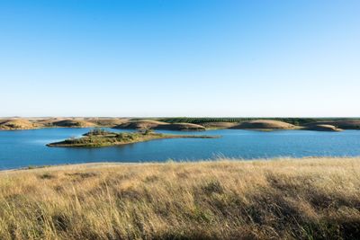
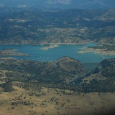
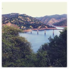
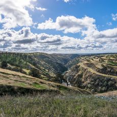
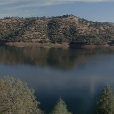
Turlock Lake State Recreation Area is a recreation area near Turlock with a large lake and forested shoreline along the Tuolumne River. The grounds include multiple coves and calm water areas, along with camping zones nestled between trees and open spaces.

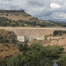
The area became a recreation site in 1950 when California State Parks acquired it through an agreement with the Turlock Irrigation District. The lake itself was created by a dam, transforming the valley into a water recreation destination.

The park maintains native riparian vegetation representing the original plant communities from before agricultural development changed the San Joaquin Valley. Walking through these areas, you see what the landscape looked like in its natural state.

The grounds are open from early morning through sunset and offer boat launch areas, camping sites, and designated swimming zones for day and overnight visitors. Water access is the main activity here, so visitors should plan accordingly and bring what they need for sun exposure and water activities.

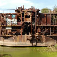
The landscape shows old dredger piles throughout the site, remnants from roughly 50 years of mining activity along the river that shaped the terrain. These mounds stand as physical reminders of the area's mining past and create an unexpected contrast with today's recreation focus.

Location: California

Inception: 1950

Website: https://parks.ca.gov/?page_id=555

GPS coordinates: 37.62720,-120.58200

Latest update: December 10, 2025 16:28

Photos
Around this place
Lake Tulloch
United States of America

Lake Tulloch

29.9 km
Lake McClure
United States of America

Lake McClure

26.5 km
McHenry Mansion
United States of America

McHenry Mansion

36.4 km
Modesto Arch
United States of America

Modesto Arch

36.9 km
Gallo Center for the Arts
United States of America

Gallo Center for the Arts

36.7 km
Knight's Ferry Bridge
United States of America

Knight's Ferry Bridge

22.6 km
Hawke Castle
United States of America

Hawke Castle

36.6 km
Gold Dredge
United States of America

Gold Dredge

9.3 km
Bloss Mansion
United States of America

Bloss Mansion

31.2 km
Merced County Courthouse
United States of America

Merced County Courthouse

36.8 km
Castle Air Museum
United States of America

Castle Air Museum

29.2 km
Hotel Covell
United States of America

Hotel Covell

36.8 km
Odd Fellows Hall
United States of America

Odd Fellows Hall

11.4 km
Shell Gas Station
United States of America

Shell Gas Station

11.4 km
El Viejo Post Office
United States of America

El Viejo Post Office

36.6 km
Abraham Schell House
United States of America

Abraham Schell House

22.8 km
Hornitos Masonic Hall No. 98
United States of America

Hornitos Masonic Hall No. 98

33.5 km
Old Adobe Barn
United States of America

Old Adobe Barn

11.5 km
Buhach Grammar School
United States of America

Buhach Grammar School

33.7 km
Kaehler-Rector House
United States of America

Kaehler-Rector House

36.7 km
Gamble Building and Miner's Bean Kettle
United States of America

Gamble Building and Miner's Bean Kettle

36 km
McHenry Museum & Historical Society
United States of America

McHenry Museum & Historical Society

36.4 km
Jacksonville Road Bridge
United States of America

Jacksonville Road Bridge

31.3 km
Wallace Dining Center
United States of America

Wallace Dining Center

32.3 km
La Grange Dam
United States of America

La Grange Dam

13.1 km
Old La Grange Schoolhouse
United States of America

Old La Grange Schoolhouse

11.5 km
Coulterville Main Street Historic District
United States of America

Coulterville Main Street Historic District

35.1 km
Don Pedro Reservoir
United States of America

Don Pedro Reservoir

22.3 km
Show the full map
Reviews

Visited this place? Tap the stars to rate it and share your experience / photos with the community! Try now! You can cancel it anytime.

« Turlock Lake State Recreation Area - State recreation area in Stanislaus County, United States » is provided by Around Us (aroundus.com). Images and texts are derived from Wikimedia project under a Creative Commons license. You are allowed to copy, distribute, and modify copies of this page, under the conditions set by the license, as long as this note is clearly visible.

Discover hidden gems everywhere you go!

From secret cafés to breathtaking viewpoints, skip the crowded tourist spots and find places that match your style. Our app makes it easy with voice search, smart filtering, route optimization, and insider tips from travelers worldwide. Download now for the complete mobile experience.

Around Us App Screenshot

A unique approach to discovering new places

Le Figaro

All the places worth exploring

France Info

A tailor-made excursion in just a few clicks

20 Minutes