Enable Location

We need your location to show you interesting places around you

Discover nearby places

Find interesting locations and hidden gems around you

Precise directions

Get accurate directions and distances to places

Your location is never shared with other users. It's only used when you tap the location button.

Lake McClure

Log in to your account

Start exploring — it's free

Trusted by 61,362 travelers worldwide

Continue with Google
Continue with Apple
or

We will send you a code to connect

By continuing, you accept our Terms and Conditions and our Privacy Policy

Check your inbox

We've sent a pincode in your inbox. Please enter the code below.

Lake McClure

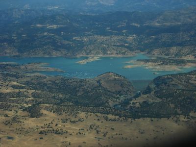
Lake McClure, Reservoir in Mariposa County, United States

Description

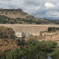
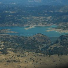
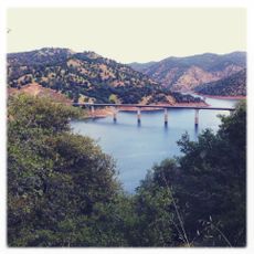
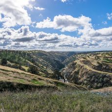
Lake McClure is a reservoir in the Sierra Nevada foothills created by the New Exchequer Dam, which holds back the waters of the Merced River. The body of water spans a considerable area and provides a major water surface in the midst of California's mountainous terrain.

History

The original Exchequer Dam was completed in 1926, establishing a significant water storage capacity in the region. The New Exchequer Dam was added in 1967, substantially expanding the reservoir's ability to hold water.

Culture

The name honors Wilbur Fiske McClure, a California state official whose work shaped regional infrastructure and outdoor recreation development. Visitors can sense this connection while exploring the foothills, where the reservoir represents a pivotal moment in the state's engineering history.

Practical

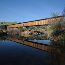
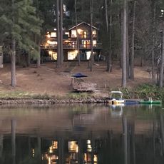
The area offers various activities for visitors, from water recreation to hiking in the surrounding landscape. Access is readily available and the region is open year-round, though water levels may fluctuate depending on the season.

Did you know?

Authorities regularly monitor mercury levels in fish from the lake to ensure angler safety and food quality standards. These monitoring efforts reveal how modern management must protect water quality and sustainable fishing practices.

Location
Elevation above the sea
2,925 m
GPS coordinates
37.64250,-120.28250
Latest update
December 8, 2025 19:53

AroundUs brings together thousands of curated places, local tips, and hidden gems, enriched daily by 60,000 contributors worldwide. Discover all places nearby (Mariposa County).

Around this place
Railtown 1897 State Historic Park
United States of America

Railtown 1897 State Historic Park

36.4 km
Lake Tulloch
United States of America

Lake Tulloch

38.9 km
Turlock Lake State Recreation Area
United States of America

Turlock Lake State Recreation Area

26.5 km
California State Mining and Mineral Museum
United States of America

California State Mining and Mineral Museum

35.5 km
Ferguson landslide
United States of America

Ferguson landslide

33.7 km
New Exchequer Dam
United States of America

New Exchequer Dam

6.4 km
Knight's Ferry Bridge
United States of America

Knight's Ferry Bridge

38.9 km
Gold Dredge
United States of America

Gold Dredge

17.1 km
Hotel Charlotte (Groveland, California)
United States of America

Hotel Charlotte (Groveland, California)

22.4 km
Track Bus No. 19
United States of America

Track Bus No. 19

36.2 km
Castle Air Museum
United States of America

Castle Air Museum

40.4 km
Mariposa County Courthouse
United States of America

Mariposa County Courthouse

32.9 km
Odd Fellows Hall
United States of America

Odd Fellows Hall

15.9 km
Abraham Schell House
United States of America

Abraham Schell House

39.6 km
Groveland Hotel
United States of America

Groveland Hotel

22.4 km
Hornitos Masonic Hall No. 98
United States of America

Hornitos Masonic Hall No. 98

16.2 km
Old Adobe Barn
United States of America

Old Adobe Barn

15.8 km
Gamble Building and Miner's Bean Kettle
United States of America

Gamble Building and Miner's Bean Kettle

20.3 km
Bower Cave
United States of America

Bower Cave

24.7 km
Jacksonville Road Bridge
United States of America

Jacksonville Road Bridge

22.4 km
Lake Lodge Beach
United States of America

Lake Lodge Beach

24.5 km
Wallace Dining Center
United States of America

Wallace Dining Center

33.5 km
La Grange Dam
United States of America

La Grange Dam

14.6 km
Old La Grange Schoolhouse
United States of America

Old La Grange Schoolhouse

15.8 km
Coulterville Main Street Historic District
United States of America

Coulterville Main Street Historic District

10.7 km
Groveland Ranger Station
United States of America

Groveland Ranger Station

25.8 km
Rim of the World Vista
United States of America

Rim of the World Vista

29.3 km
South Fork Tuolumne River Bridge
United States of America

South Fork Tuolumne River Bridge

31.1 km
Show the full map
« Lake McClure - Reservoir in Mariposa County, United States » is provided by Around Us (aroundus.com). Images and texts are derived from Wikimedia project under a Creative Commons license. You are allowed to copy, distribute, and modify copies of this page, under the conditions set by the license, as long as this note is clearly visible.

Discover hidden gems everywhere you go!

From secret cafés to breathtaking viewpoints, skip the crowded tourist spots and find places that match your style. Our app makes it easy with voice search, smart filtering, route optimization, and insider tips from travelers worldwide. Download now for the complete mobile experience.

Around Us App Screenshot

A unique approach to discovering new places

Le Figaro

All the places worth exploring

France Info

A tailor-made excursion in just a few clicks

20 Minutes

Around Us
Travel Guide & Maps
Download

Send to your phone

QR Code
1

Open the camera app on your mobile.

2

Point at the QR code with your camera. A notification will appear.

3

Tap the notification to open the link.