Enable Location

We need your location to show you interesting places around you

Discover nearby places

Find interesting locations and hidden gems around you

Precise directions

Get accurate directions and distances to places

Your location is never shared with other users. It's only used when you tap the location button.

S Bridge II

Log in to your account

Start exploring — it's free

Trusted by 62,526 travelers worldwide

Continue with Google
Continue with Apple
or

We will send you a code to connect

By continuing, you accept our Terms and Conditions and our Privacy Policy

Check your inbox

We've sent a pincode in your inbox. Please enter the code below.

S Bridge II, bridge in United States of America

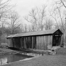
S Bridge II is a stone structure in Muskingum County that crosses a small waterway and stands out for its distinctive S-shaped form. The structure uses large sandstone blocks with thick, solid walls that show skilled craftsmanship from its era.

The structure was built in 1828 and was part of early efforts to improve travel and trade in the region. It was an essential element of the National Road, the country's first major highway designed to connect the eastern and western parts of the young nation.

The bridge takes its name from its shape, which resembles the letter S, a common design choice when builders needed to follow the natural curves of streams and terrain. This form reflects how early engineers worked with the landscape rather than against it.

The structure sits in a rural area with pathways that allow visitors to reach and examine it on foot. Visiting during pleasant weather makes access easier and allows you to fully appreciate the surroundings and details.

The structure was designed by renowned architect Benjamin Latrobe, whose engineering projects shaped the nation. The solid stone construction and thoughtful design allowed the bridge to endure nearly two centuries with minimal alteration.

The community of curious travelers

AroundUs brings together thousands of curated places, local tips, and hidden gems, enriched daily by 60,000 contributors worldwide.

Start exploring
Location
Inception
1828
Architects
Benjamin Henry Latrobe, II
GPS coordinates
39.99306,-81.74667
Latest update
February 9, 2026 11:07
Around this place
Cincinnati Zoo and Botanical Garden
United States of America

Cincinnati Zoo and Botanical Garden

255.1 km
The Wilds
United States of America

The Wilds

18.3 km
Blue Rock State Park
United States of America

Blue Rock State Park

21.6 km
John and Annie Glenn Museum
United States of America

John and Annie Glenn Museum

889 m
St. Thomas Aquinas Church
United States of America

St. Thomas Aquinas Church

22.9 km
Masonic Temple Building
United States of America

Masonic Temple Building

23 km
William Rainey Harper Log House
United States of America

William Rainey Harper Log House

1 km
Guernsey County Courthouse
United States of America

Guernsey County Courthouse

10 km
St. James Episcopal Church
United States of America

St. James Episcopal Church

22.8 km
Alameda Apartments
United States of America

Alameda Apartments

22.6 km
Colonel Joseph Taylor House
United States of America

Colonel Joseph Taylor House

13.9 km
Zanesville YWCA
United States of America

Zanesville YWCA

22.8 km
James Boggs Tannehill House
United States of America

James Boggs Tannehill House

22.2 km
Bethel Methodist Episcopal Church
United States of America

Bethel Methodist Episcopal Church

17.3 km
St. John's Lutheran Church
United States of America

St. John's Lutheran Church

22.7 km
Broom-Braden Stone House
United States of America

Broom-Braden Stone House

18.2 km
Salt Creek Covered Bridge
United States of America

Salt Creek Covered Bridge

8 km
McCracken-McFarland House
United States of America

McCracken-McFarland House

13.9 km
Broom Building
United States of America

Broom Building

13.7 km
West View
United States of America

West View

22.4 km
Ralph Hardesty Stone House
United States of America

Ralph Hardesty Stone House

3.8 km
Samuel Harper Stone House
United States of America

Samuel Harper Stone House

5 km
William B. Harris House
United States of America

William B. Harris House

21.7 km
Barnett-Criss House
United States of America

Barnett-Criss House

4.7 km
St. Nicholas' Catholic Church
United States of America

St. Nicholas' Catholic Church

22.5 km
National Road & Zane Grey Museum
United States of America

National Road & Zane Grey Museum

6.8 km
Guernsey County District Public Library
United States of America

Guernsey County District Public Library

13.9 km
Indian Camp Covered Bridge
United States of America

Indian Camp Covered Bridge

15.7 km
Show the full map
« S Bridge II - bridge in United States of America » is provided by Around Us (aroundus.com). Images and texts are derived from Wikimedia project under a Creative Commons license. You are allowed to copy, distribute, and modify copies of this page, under the conditions set by the license, as long as this note is clearly visible.

Discover hidden gems everywhere you go!

From secret cafés to breathtaking viewpoints, skip the crowded tourist spots and find places that match your style. Our app makes it easy with voice search, smart filtering, route optimization, and insider tips from travelers worldwide. Download now for the complete mobile experience.

Around Us App Screenshot

A unique approach to discovering new places

Le Figaro

All the places worth exploring

France Info

A tailor-made excursion in just a few clicks

20 Minutes

Around Us
Travel Guide & Maps
Download

Send to your phone

QR Code
1

Open the camera app on your mobile.

2

Point at the QR code with your camera. A notification will appear.

3

Tap the notification to open the link.