Enable Location

We need your location to show you interesting places around you

Discover nearby places

Find interesting locations and hidden gems around you

Precise directions

Get accurate directions and distances to places

Your location is never shared with other users. It's only used when you tap the location button.

Marine Parkway-Gil Hodges Memorial Bridge

Log in to your account

Start exploring — it's free

Trusted by 62,495 travelers worldwide

Continue with Google
Continue with Apple
or

We will send you a code to connect

By continuing, you accept our Terms and Conditions and our Privacy Policy

Check your inbox

We've sent a pincode in your inbox. Please enter the code below.

Marine Parkway-Gil Hodges Memorial Bridge

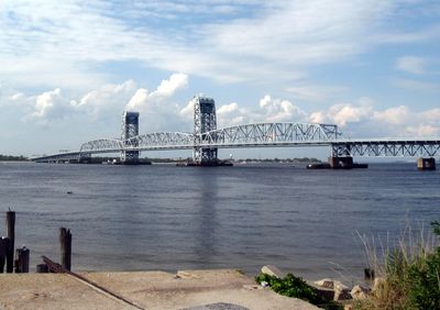
Marine Parkway-Gil Hodges Memorial Bridge, Vertical-lift road bridge in Brooklyn, United States

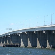
The Marine Parkway-Gil Hodges Memorial Bridge is a vertical-lift road bridge that crosses Rockaway Inlet to connect Brooklyn with the Rockaway Peninsula. It has four traffic lanes and a steel lift span designed to open for boat traffic when needed.

Construction began in 1936 under designer David Steinman and the bridge opened in 1937. The project required extensive preparation including relocating residents from Barren Island to make room for the bridge's foundation.

The bridge received its current name in 1978 to honor Gil Hodges, marking it as one of the first transportation structures named after a baseball figure.

Drivers should expect potential delays when the lift span opens to allow boats to pass underneath. The best time to cross is usually outside peak traffic hours when traffic flows more smoothly.

When it first opened, this bridge held the record for the world's longest vehicle lift span, demonstrating its importance right away through heavy traffic. Millions of vehicles crossed it in the first year, showing how essential the connection became for the area.

The community of curious travelers

AroundUs brings together thousands of curated places, local tips, and hidden gems, enriched daily by 60,000 contributors worldwide.

Start exploring
Location
Location
Official opening
July 3, 1937
Length
1,225.9 m
Longest Span
164.6 m
GPS coordinates
40.57344,-73.88494
Latest update
December 7, 2025 19:30
Around this place
Jacob Riis Park
United States of America

Jacob Riis Park

1.2 km
Trump Village
United States of America

Trump Village

7.5 km
Fort Tilden
United States of America

Fort Tilden

1.7 km
Cross Bay Veterans Memorial Bridge
United States of America

Cross Bay Veterans Memorial Bridge

5.9 km
Marine Park
United States of America

Marine Park

4.1 km
Hendrick I. Lott House
United States of America

Hendrick I. Lott House

5.8 km
Jacob Riis Park Beach 7
United States of America

Jacob Riis Park Beach 7

1.3 km
Wyckoff-Bennett Homestead
United States of America

Wyckoff-Bennett Homestead

7 km
Mill Basin Bridge
United States of America

Mill Basin Bridge

3.7 km
Kingsway Jewish Center
United States of America

Kingsway Jewish Center

6.9 km
Millennium Theater
United States of America

Millennium Theater

6.2 km
United States of America

Brighton Ballet Theater

4.2 km
Manhattan Beach Jewish Center
United States of America

Manhattan Beach Jewish Center

6.1 km
Flatlands Dutch Reformed Church
United States of America

Flatlands Dutch Reformed Church

7.1 km
Jewish Center of Coney Island
United States of America

Jewish Center of Coney Island

7 km
Sheepshead Bay Houses
United States of America

Sheepshead Bay Houses

5.2 km
Temple of Israel Synagogue
United States of America

Temple of Israel Synagogue

6.6 km
Stoothoff-Baxter-Kouwenhaven House
United States of America

Stoothoff-Baxter-Kouwenhaven House

6.4 km
Beth El Jewish Center of Flatbush
United States of America

Beth El Jewish Center of Flatbush

7 km
Rockaway Courthouse
United States of America

Rockaway Courthouse

6.1 km
Sgt. Joyce Kilmer Triangle
United States of America

Sgt. Joyce Kilmer Triangle

7.4 km
Plumb Beach
United States of America

Plumb Beach

3.2 km
Rockaway Beach
United States of America

Rockaway Beach

2.8 km
Shorefront YM/YWHA
United States of America

Shorefront YM/YWHA

6.4 km
Fort Tilden Beach
United States of America

Fort Tilden Beach

1.6 km
Jamaica Bay Wildlife Refuge
United States of America

Jamaica Bay Wildlife Refuge

6.6 km
Canarsie Beach
United States of America

Canarsie Beach

6.2 km
Sheepshead Theatre
United States of America

Sheepshead Theatre

5.8 km
Show the full map
« Marine Parkway-Gil Hodges Memorial Bridge - Vertical-lift road bridge in Brooklyn, United States » is provided by Around Us (aroundus.com). Images and texts are derived from Wikimedia project under a Creative Commons license. You are allowed to copy, distribute, and modify copies of this page, under the conditions set by the license, as long as this note is clearly visible.

Discover hidden gems everywhere you go!

From secret cafés to breathtaking viewpoints, skip the crowded tourist spots and find places that match your style. Our app makes it easy with voice search, smart filtering, route optimization, and insider tips from travelers worldwide. Download now for the complete mobile experience.

Around Us App Screenshot

A unique approach to discovering new places

Le Figaro

All the places worth exploring

France Info

A tailor-made excursion in just a few clicks

20 Minutes

Around Us
Travel Guide & Maps
Download

Send to your phone

QR Code
1

Open the camera app on your mobile.

2

Point at the QR code with your camera. A notification will appear.

3

Tap the notification to open the link.