Enable Location

We need your location to show you interesting places around you

Discover nearby places

Find interesting locations and hidden gems around you

Precise directions

Get accurate directions and distances to places

Your location is never shared with other users. It's only used when you tap the location button.

James River and Kanawha Canal

Log in to your account

Start exploring — it's free

Trusted by 61,791 travelers worldwide

Continue with Google
Continue with Apple
or

We will send you a code to connect

By continuing, you accept our Terms and Conditions and our Privacy Policy

Check your inbox

We've sent a pincode in your inbox. Please enter the code below.

James River and Kanawha Canal

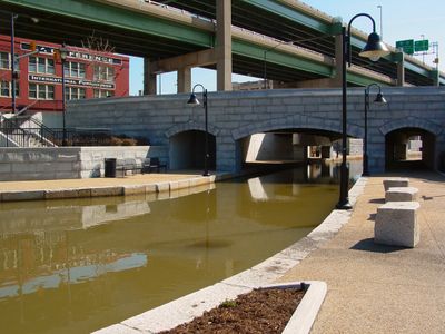
James River and Kanawha Canal, Historic canal district in Richmond, Virginia.

Description

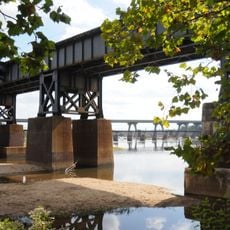
The James River and Kanawha Canal is a restored waterway in Richmond that runs from the Great Ship Lock to Bosher's Dam, connecting multiple neighborhoods along the river. The waterway displays its original infrastructure with locks, dams, and paved paths where visitors can walk alongside the water.

History

George Washington founded the James River Company in 1785, creating the nation's first major canal for commerce between eastern and western Virginia. The canal operated for over a century before railroads and other transport methods eventually replaced it.

Culture

The canal was Richmond's trade lifeline and shaped the city's appearance with warehouses and wharves that visitors can still see today. The waterfront neighborhoods grew around this commerce, with working people moving goods that connected inland farms to distant markets.

Practical

The canal is easiest to explore in downtown Richmond, where the best paths are paved and clearly marked. Wear comfortable shoes and stroll along the waterfront passages, especially during warmer months when guided tours and boat rides are available.

Did you know?

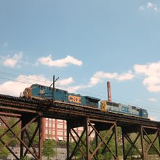
The canal's original towpath for horse-drawn boats became the foundation for the Richmond and Alleghany Railroad's tracks, the very system that replaced canal travel. Visitors can trace this shift from water to rail transport as they walk where horses once pulled boats.

Location
GPS coordinates
37.53257,-77.43191
Latest update
December 7, 2025 19:29

AroundUs brings together thousands of curated places, local tips, and hidden gems, enriched daily by 60,000 contributors worldwide. Discover all places nearby (Virginia).

Around this place
Virginia State Capitol
United States of America

Virginia State Capitol

709 m
Governor’s Mansion
United States of America

Governor’s Mansion

673 m
Lumpkin's jail
United States of America

Lumpkin's jail

536 m
Edgar Allan Poe Museum
United States of America

Edgar Allan Poe Museum

522 m
George Washington
United States of America

George Washington

691 m
Virginia Holocaust Museum
United States of America

Virginia Holocaust Museum

557 m
James Monroe Building
United States of America

James Monroe Building

442 m
Virginia Civil Rights Memorial
United States of America

Virginia Civil Rights Memorial

709 m
First African Baptist Church
United States of America

First African Baptist Church

691 m
James River Bridge
United States of America

James River Bridge

548 m
Shockoe Valley
United States of America

Shockoe Valley

638 m
First National Bank Building
United States of America

First National Bank Building

757 m
Mason's Hall
United States of America

Mason's Hall

464 m
Oliver Hill Building
United States of America

Oliver Hill Building

742 m
Virginia Department of Highways Building
United States of America

Virginia Department of Highways Building

623 m
Charlotte Williams Memorial Hospital
United States of America

Charlotte Williams Memorial Hospital

672 m
Triple Crossing
United States of America

Triple Crossing

69 m
Main Street Banking Historic District
United States of America

Main Street Banking Historic District

732 m
Rivanna Subdivision Trestle
United States of America

Rivanna Subdivision Trestle

656 m
Peninsula Subdivision Trestle
United States of America

Peninsula Subdivision Trestle

459 m
Virginia Mutual Building
United States of America

Virginia Mutual Building

757 m
George Washington Building
United States of America

George Washington Building

562 m
Morson's Row
United States of America

Morson's Row

616 m
Richmond Tobacco Exchange
United States of America

Richmond Tobacco Exchange

263 m
William Beers House
United States of America

William Beers House

692 m
Planters National Bank
United States of America

Planters National Bank

461 m
Pace-King House
United States of America

Pace-King House

636 m
Monumental Church
United States of America

Monumental Church

725 m
Show the full map
« James River and Kanawha Canal - Historic canal district in Richmond, Virginia » is provided by Around Us (aroundus.com). Images and texts are derived from Wikimedia project under a Creative Commons license. You are allowed to copy, distribute, and modify copies of this page, under the conditions set by the license, as long as this note is clearly visible.

Discover hidden gems everywhere you go!

From secret cafés to breathtaking viewpoints, skip the crowded tourist spots and find places that match your style. Our app makes it easy with voice search, smart filtering, route optimization, and insider tips from travelers worldwide. Download now for the complete mobile experience.

Around Us App Screenshot

A unique approach to discovering new places

Le Figaro

All the places worth exploring

France Info

A tailor-made excursion in just a few clicks

20 Minutes

Around Us
Travel Guide & Maps
Download

Send to your phone

QR Code
1

Open the camera app on your mobile.

2

Point at the QR code with your camera. A notification will appear.

3

Tap the notification to open the link.