Enable Location

We need your location to show you interesting places around you

Discover nearby places

Find interesting locations and hidden gems around you

Precise directions

Get accurate directions and distances to places

Your location is never shared with other users. It's only used when you tap the location button.

Yeager Airport

Log in to your account

Start exploring — it's free

Trusted by 65,461 travelers worldwide

Continue with Google
Continue with Apple
or

We will send you a code to connect

By continuing, you accept our Terms and Conditions and our Privacy Policy

Check your inbox

We've sent a pincode in your inbox. Please enter the code below.

Discussion Reviews 2 Photos
38.6k Popularity

Yeager Airport, Commercial airport in Kanawha County, United States.

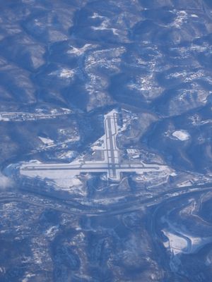
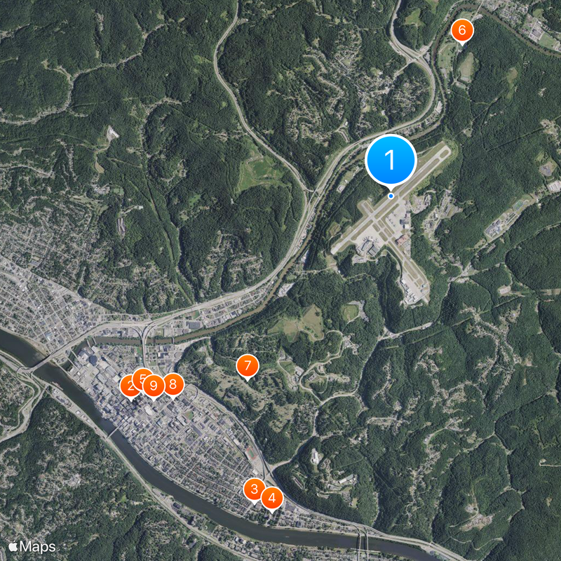
Yeager Airport is a commercial airport serving Charleston and central West Virginia, situated on a hilltop about 300 feet above the Elk and Kanawha Rivers valleys. This elevated position provides the facility with geographic advantages for regional air service.

The facility opened in 1947 as Kanawha Airport, replacing Wertz Field which had closed during World War II due to federal restrictions. This marked the start of postwar civilian aviation development for the region.

The airport was named in 1985 to honor Chuck Yeager, a pilot born in Lincoln County who became the first person to fly faster than sound. His legacy connects the place to a milestone in aviation history.

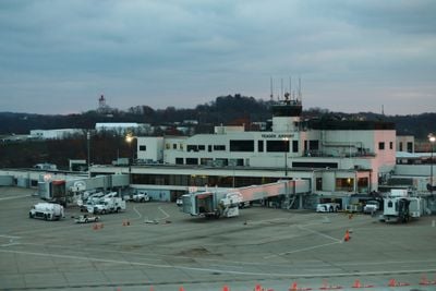
The terminal features short security lines and convenient parking close to the entrance. Travelers can find dining options, shopping facilities, and free Wi-Fi throughout the space.

The airport houses eight C-130 Hercules aircraft belonging to the West Virginia Air National Guard at McLaughlin Air National Guard Base. These cargo planes form part of the 130th Airlift Wing and add a military dimension to daily operations.

The community of curious travelers

AroundUs brings together thousands of curated places, local tips, and hidden gems, enriched daily by 60,000 contributors worldwide.

Start exploring
Location
Reference
CRW
Operator
Central West Virginia Regional Airport Authority
GPS coordinates
38.37580,-81.59310
Latest update
December 17, 2025 09:34
Around this place
Downtown Charleston Historic District
United States of America

Downtown Charleston Historic District

4.6 km
East End Historic District
United States of America

East End Historic District

4.6 km
West Virginia Capitol Complex
United States of America

West Virginia Capitol Complex

4.7 km
Daniel Boone Hotel
United States of America

Daniel Boone Hotel

4.4 km
Schoenbaum Stadium
United States of America

Schoenbaum Stadium

2.3 km
Spring Hill Cemetery Historic District
United States of America

Spring Hill Cemetery Historic District

3.2 km
Elizabeth Harden Gilmore House
United States of America

Elizabeth Harden Gilmore House

4.1 km
Samuel Starks House
United States of America

Samuel Starks House

4.3 km
West Virginia State Museum
United States of America

West Virginia State Museum

4.6 km
Breezemont
United States of America

Breezemont

4.1 km
Mattie V. Lee Home
United States of America

Mattie V. Lee Home

4.2 km
Maple Terrace Court and Walton Apartments
United States of America

Maple Terrace Court and Walton Apartments

4.6 km
Clay Center
United States of America

Clay Center

4.4 km
United States of America

West Virginia Culture Museum

4.6 km
United States of America

Cato Park

3.6 km
United States of America

East End Historic District

4.6 km
United States of America

State Theatre

4.4 km
United States of America

Cato Park Golf Course

4.1 km
Charmco Building
United States of America

Charmco Building

4.1 km
Garnet High School
United States of America

Garnet High School

4.2 km
United States of America

Walker Theatre

4.4 km
United States of America

Annex Gallery

4.6 km
United States of America

West Virginia Fallen Police Officer's Memorial

4.6 km
United States of America

West Virginia Fallen Firefighter's Memorial

4.6 km
United States of America

Women's Soldier

4.5 km
United States of America

Work of art

1.8 km
United States of America

Statue, Work of art

4.6 km
United States of America

Scenic viewpoint

3.7 km
Show the full map
Reviews
Share your experience

No review yet

Discussions
Start a discussion...

No discussion yet

« Yeager Airport - Commercial airport in Kanawha County, United States » is provided by Around Us (aroundus.com). Images and texts are derived from Wikimedia project under a Creative Commons license. You are allowed to copy, distribute, and modify copies of this page, under the conditions set by the license, as long as this note is clearly visible.

Discover hidden gems everywhere you go!

From secret cafés to breathtaking viewpoints, skip the crowded tourist spots and find places that match your style. Our app makes it easy with voice search, smart filtering, route optimization, and insider tips from travelers worldwide. Download now for the complete mobile experience.

Around Us App Screenshot

A unique approach to discovering new places

Le Figaro

All the places worth exploring

France Info

A tailor-made excursion in just a few clicks

20 Minutes

Around Us
Travel Guide & Maps
Download

Send to your phone

QR Code
1

Open the camera app on your mobile.

2

Point at the QR code with your camera. A notification will appear.

3

Tap the notification to open the link.