Enable Location

We need your location to show you interesting places around you

Discover nearby places

Find interesting locations and hidden gems around you

Precise directions

Get accurate directions and distances to places

Your location is never shared with other users. It's only used when you tap the location button.

Fort Saint Antoine

Log in to your account

Start exploring — it's free

Trusted by 61,906 travelers worldwide

Continue with Google
Continue with Apple
or

We will send you a code to connect

By continuing, you accept our Terms and Conditions and our Privacy Policy

Check your inbox

We've sent a pincode in your inbox. Please enter the code below.

Fort Saint Antoine

Fort Saint Antoine, French trading post on Lake Pepin, Wisconsin, United States.

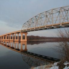
Fort Saint Antoine was a fortified wooden structure positioned where major waterways met at Lake Pepin in Wisconsin. It allowed French traders to monitor and control the flow of furs through the region's extensive network of rivers and lakes.

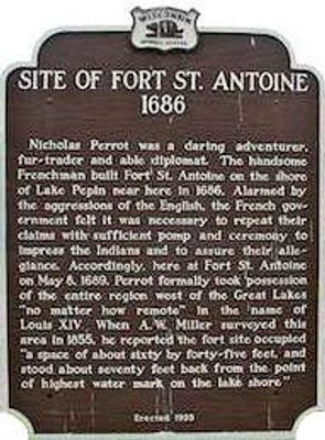
Nicolas Perrot established this fort in 1686 as a statement of French control over lands west of the Great Lakes in the name of King Louis XIV. This bold claim anchored French colonial interests in the continental interior.

The site served as a meeting ground where French traders and Dakota Sioux exchanged furs and European goods in regular commerce. These interactions shaped daily life at this remote outpost.

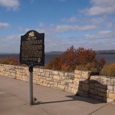
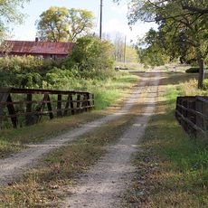
The site is marked by a historical marker south of Stockholm, Wisconsin, making it easy to locate and understand its remote setting. The location itself reveals how vital the waterways were for connecting these distant trading outposts to the larger colonial network.

French territorial claims over vast lands were asserted here through a ceremony before any formal administration existed. This reveals how colonists marked their dominance through symbolic gestures at remote locations far from European oversight.

The community of curious travelers

AroundUs brings together thousands of curated places, local tips, and hidden gems, enriched daily by 60,000 contributors worldwide.

Start exploring
Location
New France
GPS coordinates
44.46535,-92.22458
Latest update
December 14, 2025 11:01
Around this place
Frontenac State Park
United States of America

Frontenac State Park

9.3 km
Sheldon Theatre
United States of America

Sheldon Theatre

27 km
Wabasha–Nelson Bridge
United States of America

Wabasha–Nelson Bridge

17.6 km
Grace Memorial Episcopal Church
United States of America

Grace Memorial Episcopal Church

18 km
Patrick H. Rahilly House
United States of America

Patrick H. Rahilly House

11.7 km
Reads Landing School
United States of America

Reads Landing School

13.6 km
Immanuel Lutheran Church
United States of America

Immanuel Lutheran Church

24.9 km
Bear Valley Grange Hall
United States of America

Bear Valley Grange Hall

25.5 km
First Congregational Parsonage
United States of America

First Congregational Parsonage

18 km
Williamson–Russell–Rahilly House
United States of America

Williamson–Russell–Rahilly House

3.9 km
Reads Landing Overlook
United States of America

Reads Landing Overlook

11.2 km
Lorenz and Lugerde Ginthner House
United States of America

Lorenz and Lugerde Ginthner House

17.8 km
Swedish Evangelical Lutheran Church
United States of America

Swedish Evangelical Lutheran Church

25.3 km
Lucas Kuehn House
United States of America

Lucas Kuehn House

18.1 km
Zumbro Parkway Bridge
United States of America

Zumbro Parkway Bridge

26 km
Alexander Thoirs House
United States of America

Alexander Thoirs House

17.5 km
Wabasha County Poor House
United States of America

Wabasha County Poor House

20 km
Lake City City Hall
United States of America

Lake City City Hall

3.9 km
Clara and Julius Schmidt House
United States of America

Clara and Julius Schmidt House

18.2 km
Wabasha Commercial Historic District
United States of America

Wabasha Commercial Historic District

17.7 km
Bridge No. 5827-Zumbro Falls
United States of America

Bridge No. 5827-Zumbro Falls

25.5 km
William H. and Alma Downer Campbell House
United States of America

William H. and Alma Downer Campbell House

17.7 km
James C. and Agnes M. Stout House
United States of America

James C. and Agnes M. Stout House

3.9 km
Bridge No. 12
United States of America

Bridge No. 12

19 km
Henry S. and Magdalena Schwedes House
United States of America

Henry S. and Magdalena Schwedes House

18 km
Red Wing Mall Historic District
United States of America

Red Wing Mall Historic District

26.9 km
Artesian wells ice sculptures
United States of America

Artesian wells ice sculptures

20.8 km
Gladstone Building
United States of America

Gladstone Building

26.9 km
Show the full map
« Fort Saint Antoine - French trading post on Lake Pepin, Wisconsin, United States » is provided by Around Us (aroundus.com). Images and texts are derived from Wikimedia project under a Creative Commons license. You are allowed to copy, distribute, and modify copies of this page, under the conditions set by the license, as long as this note is clearly visible.

Discover hidden gems everywhere you go!

From secret cafés to breathtaking viewpoints, skip the crowded tourist spots and find places that match your style. Our app makes it easy with voice search, smart filtering, route optimization, and insider tips from travelers worldwide. Download now for the complete mobile experience.

Around Us App Screenshot

A unique approach to discovering new places

Le Figaro

All the places worth exploring

France Info

A tailor-made excursion in just a few clicks

20 Minutes

Around Us
Travel Guide & Maps
Download

Send to your phone

QR Code
1

Open the camera app on your mobile.

2

Point at the QR code with your camera. A notification will appear.

3

Tap the notification to open the link.