Ashuelot Covered Bridge

Log in to your account

AroundUs is a community-driven map of interesting places, built by curious explorers like you. It grows with every review, story, and photo you share.
Connect to save your favorite spots, contribute locations, and create personalized routes.
Continue with Google
Continue with Apple
Continue with X
Continue with Facebook
Continue with email
By continuing, you accept our Terms and Conditions and our Privacy Policy
Create an account
Add to collection
Map
Suggest a change
Share

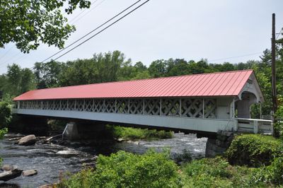
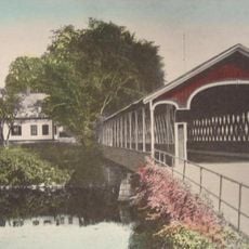
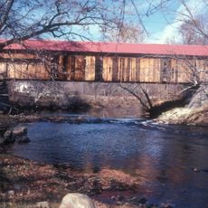
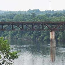
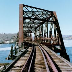
Ashuelot Covered Bridge, Wooden covered bridge in Winchester, United States.

The Ashuelot Covered Bridge is a wooden structure spanning the Ashuelot River in Winchester, New Hampshire, built to carry road traffic across the water. The roof has extended eaves that shelter the internal truss, while a 29-foot-wide passage serves both vehicles and pedestrians with sidewalks on each side.

The bridge was constructed between 1864 and 1865, replacing an earlier structure that occupied the same site since 1853. After a major storm in 1938 damaged the bridge, repairs revealed older wooden elements within the framework, indicating that materials from the previous crossing were incorporated into the new design.

The bridge displays 19th-century craftsmanship through its lattice pattern, visible in how the wooden beams create a network of light and shadow as you walk through. This construction method became characteristic of the region and reflects how builders solved structural challenges with wood.

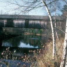
The bridge sits on Bolton Road and welcomes both vehicles and pedestrians, with sidewalks on each side for safe passage. When visiting, keep in mind that the interior can feel dimly lit due to the roof, and the structure shows its age, so moving carefully is recommended.

This structure stands out for how builders reused materials from its predecessor structure, a practice documented when repairs after the 1938 storm revealed the older beams still inside. Such resourcefulness reflected the pragmatic approach to construction in rural areas during that period.

Location: New Hampshire

GPS coordinates: 42.77639,-72.42389

Latest update: December 14, 2025 13:01

Photos
Around this place
Fort Dummer
United States of America

Fort Dummer

12 km
Mount Grace
United States of America

Mount Grace

11 km
Schell Bridge
United States of America

Schell Bridge

7.5 km
Mount Grace State Forest
United States of America

Mount Grace State Forest

10.9 km
West Swanzey Covered Bridge
United States of America

West Swanzey Covered Bridge

13.2 km
Bennett's Meadow Bridge
United States of America

Bennett's Meadow Bridge

11.1 km
Slate Covered Bridge
United States of America

Slate Covered Bridge

10.4 km
Coombs Covered Bridge
United States of America

Coombs Covered Bridge

8.6 km
Winchester Memorial Church
United States of America

Winchester Memorial Church

3.4 km
Conant Public Library
United States of America

Conant Public Library

3.3 km
Holman & Merriman Machine Shop
United States of America

Holman & Merriman Machine Shop

4.4 km
Todd Block
United States of America

Todd Block

5.7 km
Winchester Town Hall
United States of America

Winchester Town Hall

3.3 km
Pond Road Chapel
United States of America

Pond Road Chapel

7.9 km
Governor Hunt House
United States of America

Governor Hunt House

7.5 km
Tontine Building
United States of America

Tontine Building

13.6 km
Northfield Main Street Historic District
United States of America

Northfield Main Street Historic District

9.2 km
Pine Street School
United States of America

Pine Street School

7.8 km
Richmond School House No. 6
United States of America

Richmond School House No. 6

12.5 km
Rail Bridge, Northfield, Massachusetts
United States of America

Rail Bridge, Northfield, Massachusetts

8.3 km
Richmond Town Hall
United States of America

Richmond Town Hall

12.8 km
Vernon District Schoolhouse No. 4
United States of America

Vernon District Schoolhouse No. 4

8.4 km
Madame Sherri's Castle
United States of America

Madame Sherri's Castle

12.5 km
Warwick Fire Tower
United States of America

Warwick Fire Tower

11 km
B&M Connecticut River Bridge
United States of America

B&M Connecticut River Bridge

12.1 km
Charles Dana Bridge
United States of America

Charles Dana Bridge

13.3 km
Anna Hunt Marsh Bridge
United States of America

Anna Hunt Marsh Bridge

13.6 km
Christian Hill Road Bridge
United States of America

Christian Hill Road Bridge

13.3 km
Show the full map
Reviews

Visited this place? Tap the stars to rate it and share your experience / photos with the community! Try now! You can cancel it anytime.

« Ashuelot Covered Bridge - Wooden covered bridge in Winchester, United States » is provided by Around Us (aroundus.com). Images and texts are derived from Wikimedia project under a Creative Commons license. You are allowed to copy, distribute, and modify copies of this page, under the conditions set by the license, as long as this note is clearly visible.

Discover hidden gems everywhere you go!

From secret cafés to breathtaking viewpoints, skip the crowded tourist spots and find places that match your style. Our app makes it easy with voice search, smart filtering, route optimization, and insider tips from travelers worldwide. Download now for the complete mobile experience.

Around Us App Screenshot

A unique approach to discovering new places

Le Figaro

All the places worth exploring

France Info

A tailor-made excursion in just a few clicks

20 Minutes