Enable Location

We need your location to show you interesting places around you

Discover nearby places

Find interesting locations and hidden gems around you

Precise directions

Get accurate directions and distances to places

Your location is never shared with other users. It's only used when you tap the location button.

Mount Grace

Log in to your account

Start exploring — it's free

Trusted by 64,612 travelers worldwide

Continue with Google
Continue with Apple
or

We will send you a code to connect

By continuing, you accept our Terms and Conditions and our Privacy Policy

Check your inbox

We've sent a pincode in your inbox. Please enter the code below.

Mount Grace
Discussion Reviews 1 Photos
3.4k Popularity

Mount Grace, Mountain summit in Massachusetts, US

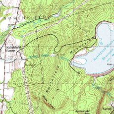
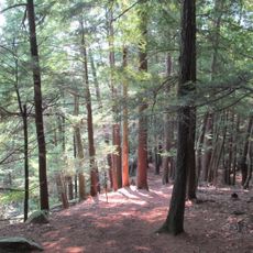
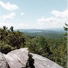
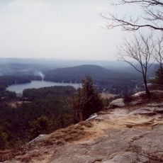
Mount Grace is a forested summit in northern Massachusetts, reaching about 1,600 feet (490 m) in elevation. Several marked trails cross the slopes, including the Round the Mountain Trail, which circles the base before climbing toward the top.

The land around the mountain was used at different times as a prison camp and as a ski area, leaving traces that are still visible today along the trails. These layers of use show how the mountain shifted between practical functions over the decades.

The name Grace likely comes from a local family or early settler, though no single account is agreed upon. Hikers today often stop near the old stone foundation near the summit, a visible trace of earlier human presence on the hill.

Several trailheads with unpaved parking areas give access to the mountain from different sides, so visitors can choose the starting point that suits them best. The trails are well marked, but sturdy footwear is a good idea since the ground can be slippery after rain.

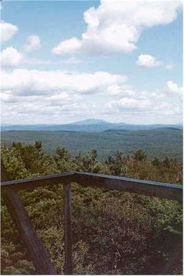
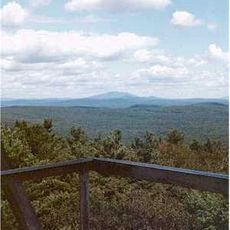
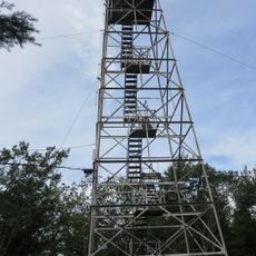
The fire observation tower at the summit was once part of a regional network used to spot forest fires across New England before aerial patrols took over. Unlike many others in the network, this tower is still standing and can be seen on arrival at the top.

The community of curious travelers

AroundUs brings together thousands of curated places, local tips, and hidden gems, enriched daily by 60,000 contributors worldwide.

Start exploring
Location
GPS coordinates
42.69175,-72.35509
Latest update
March 3, 2026 13:57
Around this place
Doane's Falls
United States of America

Doane's Falls

13.4 km
Royalston Falls
United States of America

Royalston Falls

9.3 km
Tully Lake
United States of America

Tully Lake

12.6 km
Northfield Mountain
United States of America

Northfield Mountain

11.1 km
Tully Mountain
United States of America

Tully Mountain

9.9 km
Schell Bridge
United States of America

Schell Bridge

8.4 km
Jacobs Hill
United States of America

Jacobs Hill

12.6 km
Mount Grace State Forest
United States of America

Mount Grace State Forest

846 m
United States of America

Crag Mountain

7.4 km
Tully Trail
United States of America

Tully Trail

12.5 km
Ashuelot Covered Bridge
United States of America

Ashuelot Covered Bridge

11 km
United States of America

Spirit Falls

12.5 km
Bennett's Meadow Bridge
United States of America

Bennett's Meadow Bridge

9.6 km
Orange Center Historic District
United States of America

Orange Center Historic District

11.8 km
Winchester Memorial Church
United States of America

Winchester Memorial Church

9.4 km
Conant Public Library
United States of America

Conant Public Library

9.5 km
Simeon Alexander, Jr., House
United States of America

Simeon Alexander, Jr., House

10.8 km
Winchester Town Hall
United States of America

Winchester Town Hall

9.3 km
Grand Army of the Republic Hall
United States of America

Grand Army of the Republic Hall

11.7 km
Northfield Main Street Historic District
United States of America

Northfield Main Street Historic District

8.2 km
Pine Street School
United States of America

Pine Street School

7.8 km
Richmond School House No. 6
United States of America

Richmond School House No. 6

9.7 km
Rail Bridge, Northfield, Massachusetts
United States of America

Rail Bridge, Northfield, Massachusetts

8.7 km
Richmond Town Hall
United States of America

Richmond Town Hall

10.6 km
Gill Center Historic District
United States of America

Gill Center Historic District

13.1 km
Vernon District Schoolhouse No. 4
United States of America

Vernon District Schoolhouse No. 4

9.6 km
Warwick Fire Tower
United States of America

Warwick Fire Tower

51 m
Tully Cemetery
United States of America

Tully Cemetery

10.3 km
Show the full map
Reviews
Share your experience

No review yet

Discussions
Start a discussion...

No discussion yet

« Mount Grace - Mountain summit in Massachusetts, US » is provided by Around Us (aroundus.com). Images and texts are derived from Wikimedia project under a Creative Commons license. You are allowed to copy, distribute, and modify copies of this page, under the conditions set by the license, as long as this note is clearly visible.

Discover hidden gems everywhere you go!

From secret cafés to breathtaking viewpoints, skip the crowded tourist spots and find places that match your style. Our app makes it easy with voice search, smart filtering, route optimization, and insider tips from travelers worldwide. Download now for the complete mobile experience.

Around Us App Screenshot

A unique approach to discovering new places

Le Figaro

All the places worth exploring

France Info

A tailor-made excursion in just a few clicks

20 Minutes

Around Us
Travel Guide & Maps
Download

Send to your phone

QR Code
1

Open the camera app on your mobile.

2

Point at the QR code with your camera. A notification will appear.

3

Tap the notification to open the link.