Crag Mountain

Log in to your account

AroundUs is a community-driven map of interesting places, built by curious explorers like you. It grows with every review, story, and photo you share.
Connect to save your favorite spots, contribute locations, and create personalized routes.
By continuing, you accept our Terms and Conditions and our Privacy Policy
Add to collection
Map
Suggest a change
Share

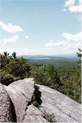
Crag Mountain, Mountain summit in Northfield, Massachusetts, United States.
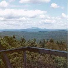
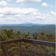
Crag Mountain reaches an elevation of 1,503 feet with a narrow, steep terrain and a knife-edge summit overlooking the surrounding Massachusetts landscape.

The mountain formed 400 million years ago and features quartzite formations that demonstrate the geological development of the Massachusetts region through time.

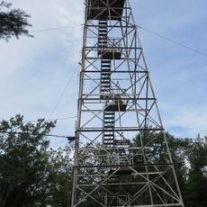
The Metacomet-Monadnock Trail system on Crag Mountain serves as a central point for nature education and outdoor recreation in Franklin County.

Access to the summit requires following white blazes from Gulf Road, with three USGS benchmarks marking the path within half a mile of the peak.

The mountain channels water through its eastern slopes into Jack's Brook and Keyup Brook, which flow toward the Millers River system.

Location: Massachusetts

GPS coordinates: 42.64370,-72.41814

Latest update: March 17, 2025 20:02

Around this place
Show the full map
Metacomet-Monadnock Trail
United States of America

Metacomet-Monadnock Trail

10.8 km
French King Bridge
United States of America

French King Bridge

8.2 km
Bear's Den
United States of America

Bear's Den

13.6 km
Northfield Mountain
United States of America

Northfield Mountain

3.7 km
Tully Mountain
United States of America

Tully Mountain

13.8 km
Mount Grace
United States of America

Mount Grace

7.4 km
Wendell State Forest
United States of America

Wendell State Forest

10.8 km
Connecticut River Greenway State Park
United States of America

Connecticut River Greenway State Park

10.9 km
Schell Bridge
United States of America

Schell Bridge

8.2 km
Mount Grace State Forest
United States of America

Mount Grace State Forest

8.3 km
Turners Falls Road Bridge
United States of America

Turners Falls Road Bridge

12.3 km
Turners Falls–Gill Bridge
United States of America

Turners Falls–Gill Bridge

11.5 km
Bennett's Meadow Bridge
United States of America

Bennett's Meadow Bridge

6.2 km
Orange Center Historic District
United States of America

Orange Center Historic District

10.7 km
Bernardston Congregational Unitarian Church
United States of America

Bernardston Congregational Unitarian Church

11.2 km
Simeon Alexander, Jr., House
United States of America

Simeon Alexander, Jr., House

3.9 km
Grand Army of the Republic Hall
United States of America

Grand Army of the Republic Hall

10.6 km
Turners Falls Historic District
United States of America

Turners Falls Historic District

12 km
Northfield Main Street Historic District
United States of America

Northfield Main Street Historic District

6.7 km
Pine Street School
United States of America

Pine Street School

7.6 km
Wendell Town Common Historic District
United States of America

Wendell Town Common Historic District

10.7 km
Powers Institute Historic District
United States of America

Powers Institute Historic District

11.5 km
Rail Bridge, Northfield, Massachusetts
United States of America

Rail Bridge, Northfield, Massachusetts

7.7 km
Gill Center Historic District
United States of America

Gill Center Historic District

6.7 km
Vernon District Schoolhouse No. 4
United States of America

Vernon District Schoolhouse No. 4

8.5 km
Great Falls Discovery Center
United States of America

Great Falls Discovery Center

11.9 km
Warwick Fire Tower
United States of America

Warwick Fire Tower

7.4 km
Tully Cemetery
United States of America

Tully Cemetery

13.7 km
Show the full map

Reviews

Visited this place? Tap the stars to rate it and share your experience / photos with the community! Try now! You can cancel it anytime.

« Crag Mountain: Mountain summit in Northfield, Massachusetts, United States » is provided by Around Us (aroundus.com). Images and texts are derived from Wikimedia project under a Creative Commons license. You are allowed to copy, distribute, and modify copies of this page, under the conditions set by the license, as long as this note is clearly visible.

Discover hidden gems everywhere you go!

From secret cafés to breathtaking viewpoints, skip the crowded tourist spots and find places that match your style. Our app makes it easy with voice search, smart filtering, route optimization, and insider tips from travelers worldwide. Download now for the complete mobile experience.

Around Us App Screenshot

A unique approach to discovering new places

Le Figaro

All the places worth exploring

France Info

A tailor-made excursion in just a few clicks

20 Minutes