Enable Location

We need your location to show you interesting places around you

Discover nearby places

Find interesting locations and hidden gems around you

Precise directions

Get accurate directions and distances to places

Your location is never shared with other users. It's only used when you tap the location button.

French King Bridge

Log in to your account

Start exploring — it's free

Trusted by 62,949 travelers worldwide

Continue with Google
Continue with Apple
or

We will send you a code to connect

By continuing, you accept our Terms and Conditions and our Privacy Policy

Check your inbox

We've sent a pincode in your inbox. Please enter the code below.

French King Bridge
Discussion Reviews 1 Photos
10.5k Popularity

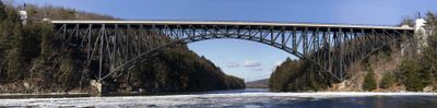
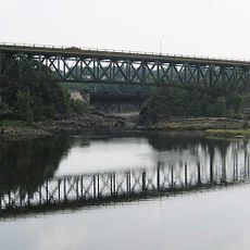
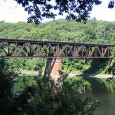
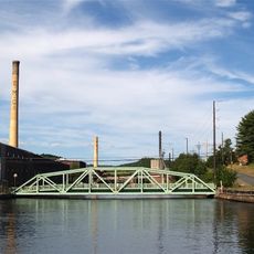
French King Bridge, Deck arch bridge on Route 2 in Gill, Massachusetts.

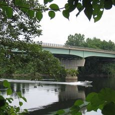
The French King Bridge is a steel deck arch bridge spanning the Connecticut River with three main sections and rising about 43 meters above the water. It carries Route 2 traffic between Erving and Gill in Massachusetts.

The structure was completed in 1932 by the Massachusetts State Highway Department to replace a hazardous section of the Mohawk Trail. Its construction was designed to provide a safer crossing between communities in the region.

The American Institute of Steel Construction selected this bridge as the most beautiful steel bridge in its class during the inaugural year of 1932.

The crossing is heavily used as a main traffic route and can be busy during peak hours. The roadway accommodates vehicles in both directions with a safe passage over the river.

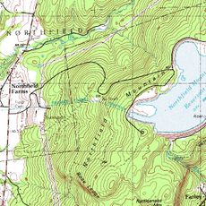
Near the bridge sits French King Rock, a rocky formation in the Connecticut River that got its name from conflicts between French colonists and Native peoples. This geographical feature has shaped the landscape's identity for centuries.

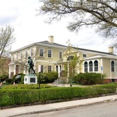
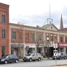
The community of curious travelers

AroundUs brings together thousands of curated places, local tips, and hidden gems, enriched daily by 60,000 contributors worldwide.

Start exploring
Location
Inception
September 10, 1932
Official opening
September 10, 1932
Height
43 m
Length
238.4 m
GPS coordinates
42.59780,-72.49670
Latest update
December 8, 2025 19:52
Around this place
Metacomet-Monadnock Trail
United States of America

Metacomet-Monadnock Trail

6.6 km
Bookmill
United States of America

Bookmill

7.5 km
United States of America

Poet's Seat Tower

7.4 km
Northfield Mountain
United States of America

Northfield Mountain

4.8 km
Wendell State Forest
United States of America

Wendell State Forest

6.4 km
Connecticut River Greenway State Park
United States of America

Connecticut River Greenway State Park

3.8 km
Canalside Rail Trail Bridge
United States of America

Canalside Rail Trail Bridge

6.7 km
United States of America

Crag Mountain

8.2 km
General Pierce Bridge
United States of America

General Pierce Bridge

7.1 km
Turners Falls Road Bridge
United States of America

Turners Falls Road Bridge

5.5 km
Weldon Hotel
United States of America

Weldon Hotel

8.1 km
Main Street Historic District
United States of America

Main Street Historic District

8.7 km
Turners Falls–Gill Bridge
United States of America

Turners Falls–Gill Bridge

4.8 km
Leavitt-Hovey House
United States of America

Leavitt-Hovey House

8.5 km
Bennett's Meadow Bridge
United States of America

Bennett's Meadow Bridge

9.7 km
Springfield Terminal railroad bridge, Deerfield
United States of America

Springfield Terminal railroad bridge, Deerfield

6.3 km
Garden Theater Block
United States of America

Garden Theater Block

8.6 km
Bernardston Congregational Unitarian Church
United States of America

Bernardston Congregational Unitarian Church

9.2 km
United States Post Office–Greenfield Main
United States of America

United States Post Office–Greenfield Main

8.4 km
Simeon Alexander, Jr., House
United States of America

Simeon Alexander, Jr., House

5.2 km
Turners Falls Historic District
United States of America

Turners Falls Historic District

5 km
Powers Institute Historic District
United States of America

Powers Institute Historic District

9.4 km
Gill Center Historic District
United States of America

Gill Center Historic District

4.8 km
East Main-High Street Historic District
United States of America

East Main-High Street Historic District

8.3 km
Montague Center Historic District
United States of America

Montague Center Historic District

7.7 km
Great Falls Discovery Center
United States of America

Great Falls Discovery Center

5 km
Montague City Covered Bridge
United States of America

Montague City Covered Bridge

7.1 km
Guiding Star Grange
United States of America

Guiding Star Grange

8.7 km
Show the full map
Reviews
Share your experience

No review yet

Discussions
Start a discussion...

No discussion yet

« French King Bridge - Deck arch bridge on Route 2 in Gill, Massachusetts » is provided by Around Us (aroundus.com). Images and texts are derived from Wikimedia project under a Creative Commons license. You are allowed to copy, distribute, and modify copies of this page, under the conditions set by the license, as long as this note is clearly visible.

Discover hidden gems everywhere you go!

From secret cafés to breathtaking viewpoints, skip the crowded tourist spots and find places that match your style. Our app makes it easy with voice search, smart filtering, route optimization, and insider tips from travelers worldwide. Download now for the complete mobile experience.

Around Us App Screenshot

A unique approach to discovering new places

Le Figaro

All the places worth exploring

France Info

A tailor-made excursion in just a few clicks

20 Minutes

Around Us
Travel Guide & Maps
Download

Send to your phone

QR Code
1

Open the camera app on your mobile.

2

Point at the QR code with your camera. A notification will appear.

3

Tap the notification to open the link.