Turners Falls Road Bridge

Log in to your account

AroundUs is a community-driven map of interesting places, built by curious explorers like you. It grows with every review, story, and photo you share.
Connect to save your favorite spots, contribute locations, and create personalized routes.
By continuing, you accept our Terms and Conditions and our Privacy Policy

Turners Falls Road Bridge

Add to collection
Map
Suggest a change
Share

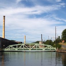
Turners Falls Road Bridge, Road bridge in Massachusetts, United States.

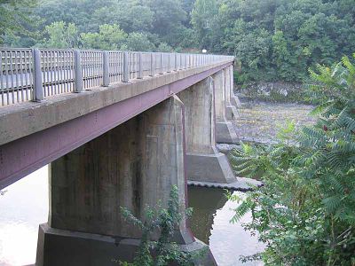
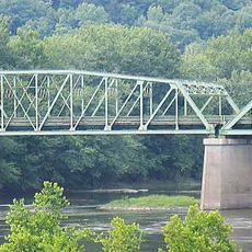
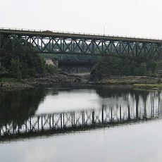
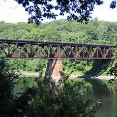
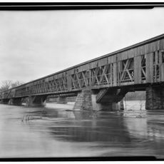
Turners Falls Road Bridge spans the Connecticut River with six spans that rest on five concrete and steel piers rising from the water. The structure stretches roughly 136 meters across and is designed primarily for vehicular traffic.

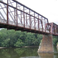
A suspension bridge built in 1871 once stood at this location before being destroyed during a major flood in 1936. The current bridge was constructed afterward to replace the damaged structure.

The bridge links two communities that depend on it for daily commerce and travel between Greenfield and Turners Falls. It has become an integral part of how residents move across the river for work and shopping.

The crossing is designed for regular vehicle traffic and offers direct access between the two riverbanks. Visitors should expect vehicular flow and respect traffic patterns when visiting.

The concrete and steel construction represents a shift from the earlier suspension design that could not withstand the forces of the Connecticut River. Engineers redesigned the supports to be stronger and more resistant to flood damage.

Location: Massachusetts

Official opening: 1936

GPS coordinates: 42.60920,-72.56140

Latest update: December 14, 2025 13:05

Photos
Around this place
French King Bridge
United States of America

French King Bridge

5.5 km
Historic Deerfield
United States of America

Historic Deerfield

7.8 km
Poet's Seat Tower
United States of America

Poet's Seat Tower

2.6 km
Northfield Mountain
United States of America

Northfield Mountain

9.7 km
Connecticut River Greenway State Park
United States of America

Connecticut River Greenway State Park

1.6 km
Canalside Rail Trail Bridge
United States of America

Canalside Rail Trail Bridge

3.5 km
General Pierce Bridge
United States of America

General Pierce Bridge

3.5 km
Dedic Site
United States of America

Dedic Site

7.1 km
Pocumtuck Ridge Trail
United States of America

Pocumtuck Ridge Trail

9.8 km
Main Street Historic District
United States of America

Main Street Historic District

4.1 km
Turners Falls–Gill Bridge
United States of America

Turners Falls–Gill Bridge

812 m
Leavitt-Hovey House
United States of America

Leavitt-Hovey House

3.9 km
Springfield Terminal railroad bridge, Deerfield
United States of America

Springfield Terminal railroad bridge, Deerfield

5.3 km
Garden Theater Block
United States of America

Garden Theater Block

4 km
Bernardston Congregational Unitarian Church
United States of America

Bernardston Congregational Unitarian Church

6.9 km
Old Tavern Farm
United States of America

Old Tavern Farm

6.3 km
United States Post Office–Greenfield Main
United States of America

United States Post Office–Greenfield Main

3.9 km
Simeon Alexander, Jr., House
United States of America

Simeon Alexander, Jr., House

8.5 km
Turners Falls Historic District
United States of America

Turners Falls Historic District

422 m
Powers Institute Historic District
United States of America

Powers Institute Historic District

6.9 km
Gill Center Historic District
United States of America

Gill Center Historic District

6.2 km
East Main-High Street Historic District
United States of America

East Main-High Street Historic District

3.7 km
Shelburne Free Public Library
United States of America

Shelburne Free Public Library

10.7 km
Montague Center Historic District
United States of America

Montague Center Historic District

8.5 km
Great Falls Discovery Center
United States of America

Great Falls Discovery Center

484 m
Montague City Covered Bridge
United States of America

Montague City Covered Bridge

3.5 km
Guiding Star Grange
United States of America

Guiding Star Grange

3.4 km
East Shelburne Cemetery
United States of America

East Shelburne Cemetery

8.9 km
Show the full map
Reviews

Visited this place? Tap the stars to rate it and share your experience / photos with the community! Try now! You can cancel it anytime.

« Turners Falls Road Bridge - Road bridge in Massachusetts, United States » is provided by Around Us (aroundus.com). Images and texts are derived from Wikimedia project under a Creative Commons license. You are allowed to copy, distribute, and modify copies of this page, under the conditions set by the license, as long as this note is clearly visible.

Discover hidden gems everywhere you go!

From secret cafés to breathtaking viewpoints, skip the crowded tourist spots and find places that match your style. Our app makes it easy with voice search, smart filtering, route optimization, and insider tips from travelers worldwide. Download now for the complete mobile experience.

Around Us App Screenshot

A unique approach to discovering new places

Le Figaro

All the places worth exploring

France Info

A tailor-made excursion in just a few clicks

20 Minutes