Enable Location

We need your location to show you interesting places around you

Discover nearby places

Find interesting locations and hidden gems around you

Precise directions

Get accurate directions and distances to places

Your location is never shared with other users. It's only used when you tap the location button.

Pocumtuck Ridge Trail

Log in to your account

Start exploring — it's free

Trusted by 61,907 travelers worldwide

Continue with Google
Continue with Apple
or

We will send you a code to connect

By continuing, you accept our Terms and Conditions and our Privacy Policy

Check your inbox

We've sent a pincode in your inbox. Please enter the code below.

Pocumtuck Ridge Trail

Pocumtuck Ridge Trail, Protected ridge trail between Deerfield and Greenfield, Massachusetts.

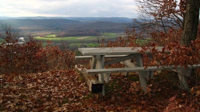
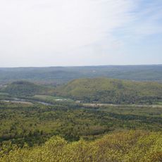
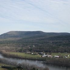
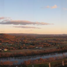
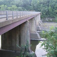
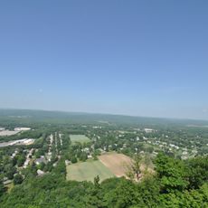
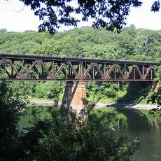
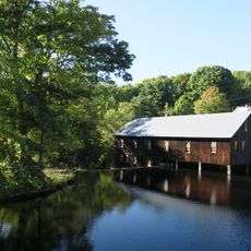
Pocumtuck Ridge Trail is a protected hiking path that follows a ridgeline between Deerfield and Greenfield, providing views across the Deerfield River and Connecticut River valleys below. The route divides into seven distinct sections clearly marked with blue blazes, with access points and parking available at multiple locations.

The ridgeline was home to the Pocumtuck people until the early 1600s, when they inhabited the Connecticut River Valley and maintained a deep connection to the landscape. The trail's name honors this indigenous presence and keeps their history alive in the region.

The ridgeline holds significance in Native American oral traditions, with a legend describing it as the petrified remains of a giant beaver. This story reflects how the Pocumtuck people connected their mythology to the land itself.

The trail can be tackled in stages since parking areas are spread across different access points, making it flexible for visitors with varying amounts of time. Sturdy hiking boots are recommended because the path varies in steepness, with some sections featuring rocky terrain and significant elevation changes.

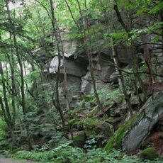
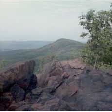
The route crosses traprock cliffs formed by ancient volcanic eruptions millions of years ago, creating distinctive dark rock faces along the ridge. These geological features shape the character of the path and set it apart from other trails in the area.

The community of curious travelers

AroundUs brings together thousands of curated places, local tips, and hidden gems, enriched daily by 60,000 contributors worldwide.

Start exploring
Location
GPS coordinates
42.52390,-72.59140
Latest update
December 14, 2025 17:41
Around this place
Buttonball Tree
United States of America

Buttonball Tree

6.2 km
Sugarloaf Mountain
United States of America

Sugarloaf Mountain

6 km
Mount Toby
United States of America

Mount Toby

5.9 km
Historic Deerfield
United States of America

Historic Deerfield

2.8 km
United States of America

Poet's Seat Tower

7.9 km
Mount Sugarloaf State Reservation
United States of America

Mount Sugarloaf State Reservation

6 km
United States of America

New England Peace Pagoda

8.7 km
Canalside Rail Trail Bridge
United States of America

Canalside Rail Trail Bridge

6.3 km
Sunderland Bridge
United States of America

Sunderland Bridge

6.3 km
Bardwell's Ferry Bridge
United States of America

Bardwell's Ferry Bridge

7.9 km
General Pierce Bridge
United States of America

General Pierce Bridge

6.4 km
Turners Falls Road Bridge
United States of America

Turners Falls Road Bridge

9.8 km
Dedic Site
United States of America

Dedic Site

3.7 km
Rattlesnake Gutter
United States of America

Rattlesnake Gutter

9.5 km
Main Street Historic District
United States of America

Main Street Historic District

7.1 km
Leavitt-Hovey House
United States of America

Leavitt-Hovey House

7.2 km
Springfield Terminal railroad bridge, Deerfield
United States of America

Springfield Terminal railroad bridge, Deerfield

5.2 km
Garden Theater Block
United States of America

Garden Theater Block

7.1 km
United States Post Office–Greenfield Main
United States of America

United States Post Office–Greenfield Main

7.1 km
North Leverett, Massachusetts
United States of America

North Leverett, Massachusetts

8.3 km
East Main-High Street Historic District
United States of America

East Main-High Street Historic District

7.2 km
Conway Center Historic District
United States of America

Conway Center Historic District

8.8 km
Robert Frost Trail
United States of America

Robert Frost Trail

6 km
Leverett Center Historic District
United States of America

Leverett Center Historic District

9.7 km
Montague Center Historic District
United States of America

Montague Center Historic District

4.8 km
Mount Toby Fire Tower
United States of America

Mount Toby Fire Tower

6 km
Montague City Covered Bridge
United States of America

Montague City Covered Bridge

6.4 km
Guiding Star Grange
United States of America

Guiding Star Grange

9.1 km
Show the full map
« Pocumtuck Ridge Trail - Protected ridge trail between Deerfield and Greenfield, Massachusetts » is provided by Around Us (aroundus.com). Images and texts are derived from Wikimedia project under a Creative Commons license. You are allowed to copy, distribute, and modify copies of this page, under the conditions set by the license, as long as this note is clearly visible.

Discover hidden gems everywhere you go!

From secret cafés to breathtaking viewpoints, skip the crowded tourist spots and find places that match your style. Our app makes it easy with voice search, smart filtering, route optimization, and insider tips from travelers worldwide. Download now for the complete mobile experience.

Around Us App Screenshot

A unique approach to discovering new places

Le Figaro

All the places worth exploring

France Info

A tailor-made excursion in just a few clicks

20 Minutes

Around Us
Travel Guide & Maps
Download

Send to your phone

QR Code
1

Open the camera app on your mobile.

2

Point at the QR code with your camera. A notification will appear.

3

Tap the notification to open the link.